Old maps are always interesting to me. And they can be very informative about how a place has developed. I have shown extracts from the First Edition OS map previously on this blog and also from the Godfrey reproductions of the Second Edition. Alan Godfrey is well attuned to the value of being able to compare maps over periods and often publishes groups of maps in an area and then the next edition so that development can be clearly seen and usually has offers giving a discount for buying two maps of the same area together. His maps are very good value at £3.50 and the service is brilliant, maps usually posted out on the day of ordering. He is especially good at industrial areas.
I also have a book of Antique Maps of the Black Country which has maps dating back to 1579 but most are not very detailed. Just a very interesting book to browse through.
There are other maps I would dearly like to see but have not yet been able to find. It would be very interesting to see any plans associated with the sale of the Glebe lands on which Blackheath was subsequently built. I have occasionally seen what I suspect may be extracts from it but have never located the whole plan.
Much of the area surrounding Rowley was heath or waste land originally and, as in many areas of the country, in the late 1800s, the landowners who owned much of the land decided to seek an Enclosure Order to enclose most of it within hedges and walls, the hope generally being that this would encourage better farming outcomes. The Enclosure Bill went forward in 1799, resulting in an Act and Award in 1807-8. The effect was to parcel out about 300 acres of common pasture in 228 separate holdings and to commute some ancient manorial duties and rights. Although common people who relied on keeping their pigs, chickens and cattle on common land were probably less enthusiastic.
Edward Chitham, my one-time Latin teacher and the originator of my interest in local history, wrote in detail in his book ‘Rowley Regis A History’ , noting that the documents associated with this showed the names of local families. It is worth trying to read this scholarly book, with many illustrations – second hand copies appear to be rare but libraries may be able to obtain it on inter-library loan.
The two Lords of the Manor were William Viscount Dudley and Ward (Rowley Regis) and Granville Leveson Gower, Marquis of Stafford (Rowley Somery). The Vicar of Clent (of which Rowley Regis was at the time still a chapelry) was compensated for the loss of tithes by 11 acres of additional glebe land at Cradley Heath and 39 acres at Blackheath, the latter sold later to fund the building of a new church, leading to the development of the ‘new town’ of Blackheath.
Existing landholders could also buy land adjoining their own property and John Beet, butcher, of Rowley Hall bought land at Whiteheath; Richard Bate, farmer bought land at Tippity Green; Isaac Downing, nailer, bought land at Turner’s Hill; Richard Gaunt land at Portway Hall; Stephen Rollinson, butcher, and Thomas Sidaway both bought land at Reddal Hill. Chitham notes that, of all the purchasers of land and those allotted it, only one – James Purser, lived at a distance, in London. All the rest were resident in the locality, many actually in Rowley parish.
Some papers relating to the Enclosure Act are at The National Archives at Kew and on my next visit I will examine those. Other copies may be in County or other archives but some documents arise from deposits of family papers from solicitors and these tend to be more scattered. Driving any distance is a problem for me at the moment, due to a knee problem so I have not been optimistic about being able to see such documents and plans any time soon.
So I was delighted when Kevin James posted a photograph of part of a map of Rowley Village, dating from 1804, on the ‘oldbury and blackcountry history’ Facebook page recently. And very obligingly, at my request, he then added a photograph of the area of the Lost Hamlets on the same map and also the Inscription and the key to the colours used on the map, also kindly giving me permission to include them in this study.
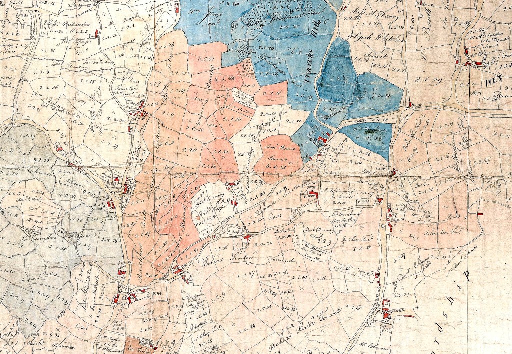
Copyright Kevin James
So this is a copy of the map which was used in the Enclosure process and reproduced, it appears fifty years later by the same artist. What a treasure! So many familiar Rowley names, some of whom were still in possession when the censuses began forty years later.

Copyright Kevin James

Copyright Kevin James
Out of interest, this is the other map Kevin posted, of Rowley Village.

Copyright Kevin James
I hope you find this map as interesting as I do. I shall continue to try to see the Enclosure Act but this glimpse of the area is very pleasing.
Useful further reading:

Copyright: Glenys Sykes
‘The Black Country as seen through antique maps’ by Eric Richardson, published by the Black Country Society. ISBN: 0 904015 60 2
‘Rowley Regis – a History’ by Edward Chitham. Published by Phillimore in 2006. ISBN: 1-86077-418-0
‘The Oxford Companion to Family and Local History’ edited by David Hey. Published by Oxford University Press in 2010. ISBN number 9 780199 532971 – an immensely useful book, used copies available for less than £5!
