Further reading on this subject has brought me to a paragraph in J Wilson Jones’s book, published in 1950. He talks about the early road system around Rowley and says
“Let us consider the early roads from the early enclosure and pre-enclosure maps, knowing that a Manor of Rowley would be connected by the earliest of roads, being the all-important demesne. Then locate the toll gate houses, not the turnpike of the busy roads, but houses where toll or tax was paid, often situated near the Lord’s Mill [which was at Tippity Green]. We have the Rowley-Dudley Road through Knowle and Powke Lane as the only marked roads, both converging upon ‘Ye Brickhouse Estate’ [which Jones thought was located at Cock Green which was between Tippity Green and Knowle] . The Toll houses are again on Powke Lane at Yewtree Gate and near Tippity Green as Tippity Green Gate. The only other land marks on the 1821 map being Freeberry’s, Hailston Hill, Perry’s Lake and Hawes Hill.”
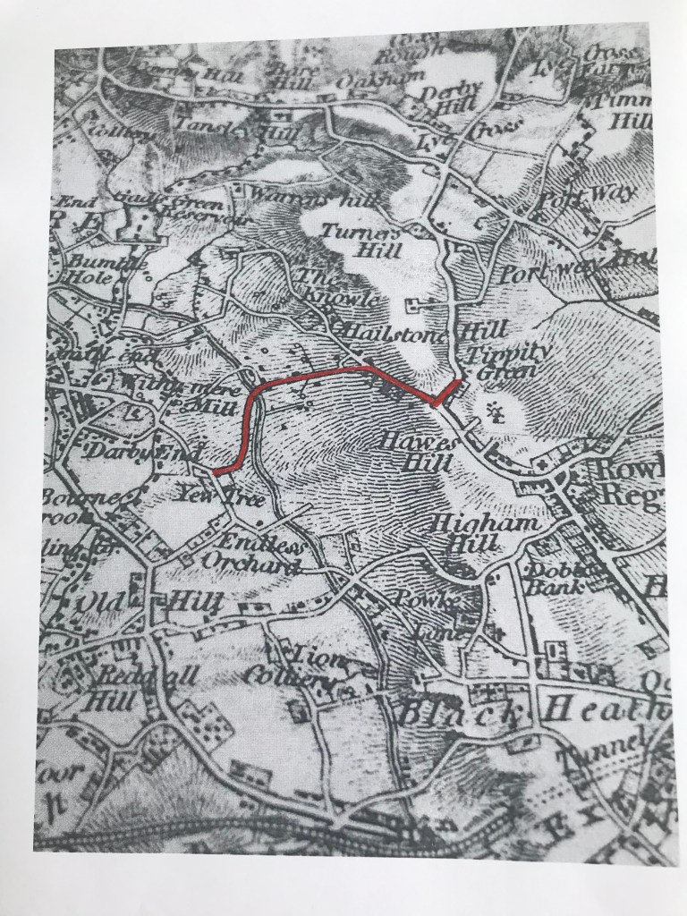
So my surmise in the last article that the Toll related to the new road from Perry’s Lake to Portway seems to be wrong. If Jones is correct, the Toll Road ran from an area known as Yew Tree on Powke Lane to Tippity Green, up what was then called Dog Lane, subsequently known as Doulton Road, (though I have been told that the canal bridge there is still called the Dog Lane Bridge on canal maps).
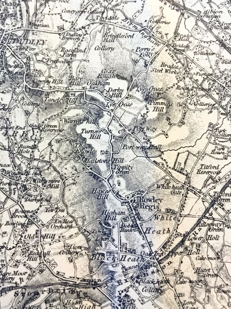
I have not been able to identify the map dated 1821 to which Jones refers. What is now called Yew Tree Lane and the public house called the Yew Tree is much higher up Powke Lane than the road Jones describes, but Yew Tree is clearly marked at the bottom of the lane on the map below . This extract from the first edition OS map, surveyed in the 1830s, shows the road which Jones says was a Toll Road and which I have marked in red.
Copyright David & Charles
The road to Portway may well have been built later by the quarry operators to facilitate the movement of their stone, and they did, after all, have plenty of material to build it with.
Always learning…
Reference: A History of the Black Country by J Wilson Jones, published c.1950.
Old maps are always interesting to me. And they can be very informative about how a place has developed. I have shown extracts from the First Edition OS map previously on this blog and also from the Godfrey reproductions of the Second Edition. Alan Godfrey is well attuned to the value of being able to compare maps over periods and often publishes groups of maps in an area and then the next edition so that development can be clearly seen and usually has offers giving a discount for buying two maps of the same area together. His maps are very good value at £3.50 and the service is brilliant, maps usually posted out on the day of ordering. He is especially good at industrial areas.
I also have a book of Antique Maps of the Black Country which has maps dating back to 1579 but most are not very detailed. Just a very interesting book to browse through.
There are other maps I would dearly like to see but have not yet been able to find. It would be very interesting to see any plans associated with the sale of the Glebe lands on which Blackheath was subsequently built. I have occasionally seen what I suspect may be extracts from it but have never located the whole plan.
Much of the area surrounding Rowley was heath or waste land originally and, as in many areas of the country, in the late 1800s, the landowners who owned much of the land decided to seek an Enclosure Order to enclose most of it within hedges and walls, the hope generally being that this would encourage better farming outcomes. The Enclosure Bill went forward in 1799, resulting in an Act and Award in 1807-8. The effect was to parcel out about 300 acres of common pasture in 228 separate holdings and to commute some ancient manorial duties and rights. Although common people who relied on keeping their pigs, chickens and cattle on common land were probably less enthusiastic.
Edward Chitham, my one-time Latin teacher and the originator of my interest in local history, wrote in detail in his book ‘Rowley Regis A History’ , noting that the documents associated with this showed the names of local families. It is worth trying to read this scholarly book, with many illustrations – second hand copies appear to be rare but libraries may be able to obtain it on inter-library loan.
The two Lords of the Manor were William Viscount Dudley and Ward (Rowley Regis) and Granville Leveson Gower, Marquis of Stafford (Rowley Somery). The Vicar of Clent (of which Rowley Regis was at the time still a chapelry) was compensated for the loss of tithes by 11 acres of additional glebe land at Cradley Heath and 39 acres at Blackheath, the latter sold later to fund the building of a new church, leading to the development of the ‘new town’ of Blackheath.
Existing landholders could also buy land adjoining their own property and John Beet, butcher, of Rowley Hall bought land at Whiteheath; Richard Bate, farmer bought land at Tippity Green; Isaac Downing, nailer, bought land at Turner’s Hill; Richard Gaunt land at Portway Hall; Stephen Rollinson, butcher, and Thomas Sidaway both bought land at Reddal Hill. Chitham notes that, of all the purchasers of land and those allotted it, only one – James Purser, lived at a distance, in London. All the rest were resident in the locality, many actually in Rowley parish.
Some papers relating to the Enclosure Act are at The National Archives at Kew and on my next visit I will examine those. Other copies may be in County or other archives but some documents arise from deposits of family papers from solicitors and these tend to be more scattered. Driving any distance is a problem for me at the moment, due to a knee problem so I have not been optimistic about being able to see such documents and plans any time soon.
So I was delighted when Kevin James posted a photograph of part of a map of Rowley Village, dating from 1804, on the ‘oldbury and blackcountry history’ Facebook page recently. And very obligingly, at my request, he then added a photograph of the area of the Lost Hamlets on the same map and also the Inscription and the key to the colours used on the map, also kindly giving me permission to include them in this study.
Copyright Kevin James
So this is a copy of the map which was used in the Enclosure process and reproduced, it appears fifty years later by the same artist. What a treasure! So many familiar Rowley names, some of whom were still in possession when the censuses began forty years later.
Copyright Kevin James
Copyright Kevin James
Out of interest, this is the other map Kevin posted, of Rowley Village.
Copyright Kevin James
I hope you find this map as interesting as I do. I shall continue to try to see the Enclosure Act but this glimpse of the area is very pleasing.
Useful further reading:
Copyright: Glenys Sykes
‘The Black Country as seen through antique maps’ by Eric Richardson, published by the Black Country Society. ISBN: 0 904015 60 2
‘Rowley Regis – a History’ by Edward Chitham. Published by Phillimore in 2006. ISBN: 1-86077-418-0
‘The Oxford Companion to Family and Local History’ edited by David Hey. Published by Oxford University Press in 2010. ISBN number 9 780199 532971 – an immensely useful book, used copies available for less than £5!
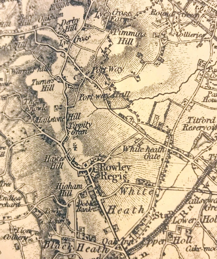
The 1851 Census shows that there was a Turnpike Gate in Tippity Green. The Gate Keeper Hannah Hadley, aged 34, was listed, along with her husband Samuel (35) who was a Nailer’s Tool Maker and their nine children. If the Toll Keeper’s cottage was like most tollhouses that you see, it would have been fairly crowded, though that appeared to have been true of most houses in this area.
I was not previously aware that there was a turnpike road in this area. From the census enumerator’s route, it was at the end of Tippity Green and just before Perry’s Lake.
Copyright David & Charles.
This map is an extract from the OS First Edition, which had been surveyed in the period up to the early 1830s. The road from Tippity Green goes up Turner’s Hill, there is no road straight on to Portway from Perry’s Lake as shown in later maps, so perhaps the very straight wide road from Perry’s Lake to Portway at what became Four Ways was a new Toll Road. In which case there would have been another Toll House, presumably where it joined Portway, with Newbury Lane on the other side of the road leading on to Oldbury. It would have been a very convenient and much flatter improvement to the route, much to the benefit of industrial traffic and at least better off people would have been willing to pay a toll to avoid the hill.
Turnpikes were apparently usually set up to improve existing roads which parishes were struggling to maintain. They were roads administered by Trusts authorised by private Acts of Parliament, on which tolls were charged at gates. They first began in 1663 and gradually increased in numbers so that by 1820 over 1000 turnpike trusts controlled about 22,000 miles of road with 7000 or more gates. Mostly they followed the old roads up hill and down dale. But by the early 1800s, new turnpike roads were being planned along routes whhich had not previously existed. This may have been such a road.
I am now trying to track down more information about this, in the form of the Act of Parliament setting up the Trust or plans and documentation and have sent enquiries to local archives. This may take some little time so this is a teaser and I will keep you informed of any more information I find. Watch this space!
In the meantime, if anyone knows of any information about this turnpike, I would be very pleased to hear from you.
I have been unable to find another Toll House Keeper listed anywhere in the Portway area in the 1851 Census but it is possible that a different enumerator might have recorded only the main occupation of the husband.
It does occur to me that perhaps the new road from Springfield to Dudley might also have been a turnpike road, and, if so, there would have been a gate keeper’s cottage there, too. But that is pure speculation!
Copyright Alan Godfrey Maps
The windmill off Tippity Green, which is documented as being there for centuries, was also still marked on the earlier map, where Windmill Farm was later.
Incidentally, you can also see from this map that the road to Whiteheath from Rowley village goes past the church and then bends round in front of Rowley Hall (I am old enough to remember where Rowley Hall was!) and straight on to Throne Road and past what became known as Ramrod Hall Farm. There was no Hanover Road then. When the quarrying and mining to the North of Rowley Hall expanded it cut off this road so another route must have been found by local people who would still have needed to access the parish church for services, baptisms, marriages and burials.
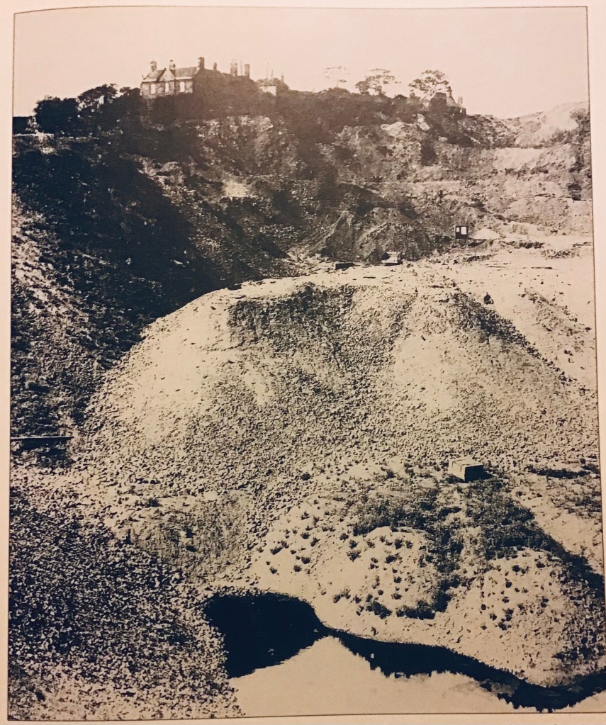
Copyright Anthony Page
This photograph shows the ‘small quarry’ below Rowley Hall. No chance of walking the old route across this.
This closure must have been inconvenient for people living in the Whiteheath and Mincing Lane area but the quarrying and mining did offer work opportunities. In due course, another road was built from Mincing Lane/Bell End to the Hall to provide a road for vehicles, called, of course, the New Hall Road which is still there, now called Newhall Road.
I recall that, more than a century later when I was a child, people still cut from Bell End up the side of the ‘bonk’, over the now flattened old pit and quarry workings, past the old reservoir to come out at Rowley Hall, on their way to Rowley village and church (or school in Hawes Lane in my case) as the shortest route available. Old habits die hard!
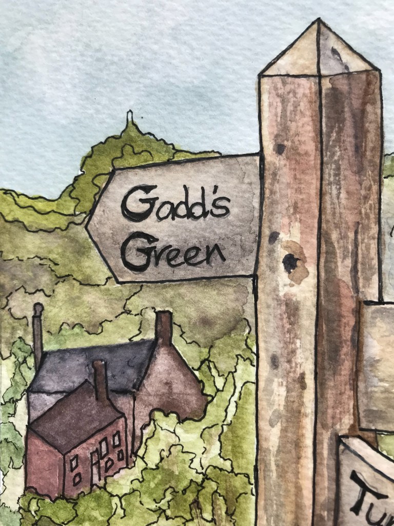
Once upon a time there was a Methodist Chapel in or between the hamlets of Gadds Green or Perry’s Lake. Who knew? There is no trace of it on any of the maps I can find but it is listed on the censuses, between Perry’s Lake and Gadds Green , in 1861 and 1871.
I first noticed when transcribing the 1871 Census for Perry’s Lake and Gadds Green that between the two hamlets there is a line which says “Primitive Methodist Chapel”. It is not mentioned in the 1881 Census but in the 1861 Census it is there, again listed between Perry’s Lake and Gadds Green both times but this time called Gadds Green Chapel. Not mentioned in the 1851 Census (although Thomas Barnsley, aged 29, living in Perry’s Lake and born in Rowley Regis, gave his occupation as “Methodist Local Preacher and labourer at Stone Quarry”.
However, in an 1844 Preaching Plan for the Dudley Circuit which is on the ‘My Primitive Methodist’ website, Perry’s Lake is among the Chapels listed as having two services each Sunday at 2.30 and 6pm. Also listed is Rowley – one service each Sunday at 6pm, though it is not clear where this chapel was, possibly services held in a private house or a rented room or even the open air, as neither Knowle nor Hawes Lane chapels are recorded as having been in operation by this date.
The Preaching Plan is an interesting document, showing the burgeoning vitality of the Methodist church in those days with a list of more than 36 chapels in and around Dudley with a few paid ministers who walked long distances to conduct services and in excess of 80 local preachers in the area, including several women. And that was only the Primitive Methodists, there were several other types of Methodists, plus Baptists, Congregationalists, Quakers, Unitarians and others all apparently thriving.
The chapel was also noted as ‘Gads Green’ on a list of Chapels, drawn up in 1867, which is again on the My Primitive Methodist website. So it definitely existed between 1844 and 1871. It would be interesting to see the 1887 OS 6″ to the mile map , just to see whether it was still there then but I can’t find this map online or in print anywhere at the moment.
The earliest 6″ OS map I have at present is dated 1904 and I can’t see a chapel marked on there in Perrys Lake or Gadds Green. There is a Chapel Cottage in Gadds Green as late as the 1911 Census but a chapel isn’t mentioned then. So I wonder whether the local Methodists transferred to other chapels, the nearest being Hawes Lane or The Knowle, both less than a mile away and surely less than a mile apart!
I found online this bit of history about the Knowle Chapel (Eric Bowater giving the information in 2019).
“The first beginning of Knowle Methodist Church met in the small kitchen of a local house,for the sum of 1s 6d.around 1860. As the membership grew it moved into a farm building in Brickhouse Farm a short distance away. Once again the membership grew and so it was decided to build a church of their own. A Church was now to be erected on the present site and was opened in December 1869 called Ebenezer. In 1890 new trouble arose with undermining which affected the chapel. The last meeting held in the chapel was held in 1907.The present church which was built in front of the old one 25th September 1907 and was a United Methodist Church.”
The Knowle site would have been quite close to the hamlets and accessible across the fields so if the earlier chapel closed people might have moved to the Knowle chapel. Reg Parsons, who grew up on Turner’s Hill, told me that he had never heard of a chapel there but that there was also a ‘tin chapel’ at Oakham, opposite the pub there so that may also have provided a spiritual home for some local people when the Perry’s Lake chapel closed.
There was an Ecclesiastical Census on 31st March 1851 (this can be downloaded free of charge from The National Archives) but many small chapels appear to have been omitted and I have been unable to find a chapel I can identify as Perry’s Lake or Gadd’s Green. The entry for St Giles shows figures for attendance which, frankly, I find rather suspect. An extract is shown here.
Copyright: The National Archives
I find it difficult to imagine 600 people at morning service with 400 children at Sunday School, 1100 people all crammed into St Giles Church for the afternoon service with 400 children at Sunday school (again) and another 100 in the evening in a rented room – such neat round figures, 1000 and 1500 people?! The return for Dudley St Thomas gives figures of 800 and 700 attending services but that for Reddal Hill claims much more modest figures of 149 at church with 223 at Sunday school in the morning with 259 and 223 respectively at later services.
As we have just entered the season of Lent, it is perhaps timely to note that several clergy, in their returns for this census (and clearly anxious that their attendances should not be underestimated by the powers that be for the future), pointed out that the date chosen for the Census was the middle Sunday of Lent. The note shown below was attached by one local Clergyman. It reads “The reason that attendance at the church appears smaller on the 30th Mar than the average is that the day is Mid-Lent Sunday, commonly called Mothering Sunday. A day much observed in this district by parents having their children and friends around their tables on this day and providing the best in their power for them.”
Copyright: The National Archives
What a picture that conjures in a few words. And a clergyman apparently much in tune with his congregation, however humble. I can remember my mother telling me as a child that Mothering Sunday was the one day of the year that domestic servants were allowed to go home to visit their mothers, often taking them gifts of food from their employers or spring flowers gathered along the way.
One nearby Anglican clergyman noted bitterly on his return, the ‘scourge of those Dissenters so prevalent in this locality’ and blamed them for his poor attendance figures – showing the hostility of some clergy to their independently minded parishioners. Nonconformists were not popular at that time with the Anglican church, generally seen as rebels and ignorant troublemakers to be corrected and brought back to the Anglican church. A history of Birmingham Road Methodist church in Blackheath recounts that their meeting started in the 1840s in a rented stable in Siviters Lane in Rowley. Dissenters, as they were known, were regarded as the ‘off-scouring of life’, the very scum of the earth’ and, on one occasion when they were unable to pay the rent for the room above the stable, they were not allowed to use the room so sang and prayed in the street outside. A note in the Register for the burial of my 5xgreat-uncle at St Giles in 1794 reads “William Rose, never came to church tho’ often warned and kindly exhorted, died suddenly”. I wonder how kind those exhortations were? To me, it seems very likely that William Rose was a Dissenter, a Methodist and that was why the Vicar was trying to lure him back.
So the hamlets of Perrys Lake and Gadds Green were fortunate to have a chapel of their own to worship in. Worship in their chosen style was an important part of life for our ancestors then and even small hamlets like Perry’s Lake had chapels – I wonder where it was? Any information would be very welcome.
Might it, just might it, have been behind the cottages in the part of Perry’s Lake which people still remember being called ‘Heaven’?
This may seem obvious but to those of us who grew up there in the mid 20th Century, seeing across the landscape almost always through an industrial haze, it was easy to forget that the hills and heaths had once been rural and agricultural landscapes and that my mother could remember, as late as the 1920s, walking over fields from Oldbury Road in Blackheath to Bell End in Rowley, seeing haystacks, picking wild flowers, paddling in the stream and watching the farmers at work.
My childhood walk to primary school at Rowley Hall was across the ‘Bonk’, one of the many huge spoil heaps from mines and quarries and in later years, unofficially, even less child friendly substances from chemical works. It was stony, gritty, pink or grey in places, green and shrubby in others with steep slopes for sliding down on tin trays, unfathomed pools and, my brother and his friend swore, a tunnel which they had explored and which led down to Whiteheath. He was right, it turned out, though I never found it, it would have been part of the tramway from Rowley Hall quarry and mine to Titford Basin. A similar tramway ran from the Hailstone quarry under the road at the Knowle down to the Dudley Canal, using gravity to move the heavy coal and stone to the waterways which would transport it further afield. The bonk was not somewhere many parents nowadays would allow their children to play unsupervised, but to us, the many children who used it as a giant playground, it was simply a natural part of our surroundings. It was only when I was an adult that it dawned on me that we had been playing on a waste heap!
But there were several farms and farmers in or near the lost hamlets on the 1841 census and some of these were still there in the 1940s; perhaps someone will tell me one or two are still there.
They were, like other places, called by different names at different times. Sometimes Freebodies Farm, Hailstone Farm, Brick House Farm, Gadds Green Farm, Turner’s Hill Farm, Windmill Farm, Portway Hall Farm – different records used different names, perhaps depending on the source of the information. At other times they would have been known by the names of whoever was farming there. Even in the 1950s and 60s, once you had left Springfield on the way to Dudley, there were green spaces either side of the road, though there may once have been quarries and mines there. Not smooth green meadows but greenish.
Reg Parsons, who was born and grew up on Turner’s Hill told me that his mother and father, who had a shop in Doulton Road, were walking on Turmer’s Hill one day and his mother saw some wild sweet peas growing in the hedge. What a lovely place this would be to live, she said. So when a piece of land with three condemned cottages became available there, they bought it, Reg’s father demolished the cottages and built a new house, No 2, Turner’s Hill and they moved to it. That was later sold to a local businessman who wanted to live looking over the golf course before that, too was demolished. What a view some of these houses must have had and how lovely to think that wild sweet peas grew in the hedges.
Reg recounts that his father worked in Dudley and, when he needed items from the shop at Springfield, he would get off the bus there, get his shopping and then cut across to walk up over the fields and home. Reg also recounted that, when he was at Britannia Road School (a fair walk in itself) he would call in at a farm off Hawes Lane to milk two of their cows. On the way home he would call in and milk the cows again, having his evening meal with the farmer and then walking home. As Reg said, he was working longer days than when he started his first real job. But his family – and other families in the area were mostly self-sufficient, keeping chickens and a pig, growing vegetables and getting milk from the local farm.
The map from which the extract below is taken, the First Edition of the Ordnance Survey, shows the Turner’s Hill area. This One Inch to the Statute Mile map was derived from two topographical surveys, the first completed between 1814 and 1817 by members of the Royal Military Surveyors and Draftsmen and probably assisted by local surveyors hired for the task. Numerous revisions for the rapidly changing Black Country were completed by 1831-1832, shortly before the first printing in 1834. Copies of the original surveys are preserved in the British Museum. Sheet 62, from which this small extract is taken, was engraved on four separate sheets of copper by the engravers’ workshop at the Tower of London where the first copies were also printed. The names of surveyors, engravers and printers are all recorded. This fascinating information is printed on the David and Charles Reprint edition, along with a great deal more detailed information. My recently acquired copy cost me the grand sum of less than £10, including postage so if, like me, you love old maps, it is worth seeking one out.
Information on the maps tells us that “The engravers’ workshop at the Tower was under the direction of Benjamin Baker. He employed six or seven assistants, each of whom was responsible for a particular aspect of the map – hills, water, woods, lettering and so on.” The Rowley Hills would have provided plenty of work for the one responsible for hachuring the hills!
Copyright David & Charles, Newton Abbot, Devon.
The map shows that most of the area of the Rowley Hills was still undeveloped then, although clusters of houses and some quarries are shown, the steel works at the Brades is shown and the railways are already marked.
The map shown below is an extract from the very useful Alan Godfrey Reprint of the 1904 OS 6″ to the mile, sixty years or so after the 1st Edition where you can see much more detail of the quarries around the hamlets. The hatching shows that many of the houses backed on to sheer drops into the quarries and many would end up being consumed by the quarrying operations. The Prospect Quarry was the site of a windmill at one time and there was still a Windmill Farm in Tippity Green appearing in records long after the mill had gone.
Copyright: Alan Godfrey Maps
So while we may have gone to Quinton in my childhood to see the bluebells or to Clent to ‘the real countryside’, there were some green spaces of sorts all around us and around our ancestors, despite the prevalence of quarrys, factories and pits. Interestingly, the old quarries are apparently now being filled in and greened over so perhaps the hills will become a green and pleasant land again after all these years. Though one suspects that the push for new housing may take priority…
That was the question posed last autumn on the Facebook page ‘I remember Blackheath and Rowley Regis’. The question was asked by someone who was commemorating local men who had given their lives in WW1 by placing poppy wreaths near where they had lived and she could not find Gadds Green anywhere locally.
I was taken by surprise. Researching my Rowley family, and having an ever expanding collection of older edition maps of the area, I had known for many years that Gadds Green was one of several small hamlets situated on or at the foot of Turner’s Hill, less than a mile from the village proper and the church. But, because I have not lived in Rowley Regis for more than 50 years, I had not realised that Gadds Green simply did not exist now, quarried out of existence, along with most of the houses on Turner’s Hill and Perry’s Lake. The quarry which had given so many men their employment had ended up taking their homes.
It seems likely to me that many of the place names in this area – Perry’s Lake, Gadd’s Green and Turner’s Hill may be related to families who owned the land or who lived there, especially as they tend in earlier records to have an apostrophe, although this often fell out of use in later years. The surname Perry appears in the Parish Registers as early as 1641, Turner in 1651 and Gadd in 1653 so these families had been in the village for centuries. Further research into Hearth taxes and other Land documents in various archives may cast further light on this theory when I can access records. Transcribing sequences of baptismal registers has also taught me that what people called their places of birth and residence varied from time to time and that what Priests and Ministers called them varied, too. Some place and street names appear to be very old – Powke Lane is shown on a map dated 1775 and in the St Giles Registers as early as 1723, Gosty Hill in 1729
Some place names appear in use for a short time and then disappear without trace, such as Blackberry Town which I think was somewhere below Springfield. There was a Treacle Street in the same area in the 1841 but not the 1851 Census. What I knew as Dudley Road, going from Rowley through Springfield– my birthplace! – to Dudley simply did not exist until the late 1800s, the route from Halesowen to Dudley, according to J Wilson Jones skirted Furnace Hill, past Coombe Mills, the Woodgate, Coombs Wood, Gorsty Hill over the Canal Tunnel and Slecks Hilloock down the present day Station Road, skirting Codsall Coppice to Old Hill. The later main Halesowen Road was an unimportant track weaving its way towards the abbey , leading some to speculate that this was a Pilgrim’s Way. Climbing to the Knoll (Knowle) the road then went via Tipperty Green, Perry’s Lake and then up Turner’s Hill to Oakham, Lye Cross and Dudley. The road we now know as the Dudley Road through Springfield was marked on the 1884 First Edition OS map as the “New Rowley Road”. Until that was built, if you wanted to go to Dudley, it was the high road over the Hill!
In the meantime, I have started work on a One Place Study which I am calling Rowley Regis – the Lost Hamlets, as a place to record all that I have learned about these now lost hamlets, to record information from censuses, parish records and family stories.
As part of my One Page Study, I have been transcribing censuses for the hamlets of Perry’s Lake, Gadd’s Green and Turner’s Hill – starting with the 1851, as that has much more information than the 1841. I have transcribed four censuses so far – 1841, 1851, 1861 and 1871 and am working on 1881. It is very interesting to see families intermarry, move short distances and occupations change over the decades, the latter something also observable in the transcription of parish Baptismal registers which record father’s occupations.
More detailed posts will be coming on the individual censuses and on some of the families living in the area.
Rowley Regis has, it seems, always consisted of not only the ancient parish but also of a number of hamlets, large and small arranged around the village, like satellites.
The introduction to the transcribed Parish Registers, published by the Staffordshire Parish Registers Society in 1915, and written by the transcriber Miss Henrietta Mary Auden, a Fellow of the Royal Historical Society, or some other knowledgeable authority on local matters offers this commentary:
“The parish in medieval times comprised many isolated houses and hamlets, homes originally of settlers in the forest, and as late as 1842 it was remarkable for the number of old small enclosures. The Manor is not mentioned in Domesday but was apparently a Royal Manor before the Conquest. “
This perhaps laid the pattern of numerous distinct small settlements which persisted until the late 1800s, after which they gradually merged until there was no open space between them. A teacher at the local grammar school in the 1980s commented recently on the local Facebook site that she was amazed, on moving to the area to teach, to find that the local people were very clear about which of these hamlets they lived in, even though, to her as an outsider, there appeared to be no formal or recognizable boundaries that she could identify.
In 1851 William White wrote “The Parish of Rowley Regis forms part of the great Barony of Dudley and contains 7,438 inhabitants and 3,350 acres of land, of which the executors of the late Earl Dudley are lords and owners, and hold Court Leet here in September. The parish comprises the large but indifferently built village of Rowley, seated on the declivity of a lofty hill two and a half miles S.E. of Dudley and about 20 hamlets all of which maintain their poor conjointly, and are occupied chiefly by nailers, chain makers and the miners, forgemen etc employed in the extensive coal and iron works here. “
Twenty hamlets are listed by White in 1851:
Blackheath, Corngreaves, Cradley Heath, Gosty Hill, Haden Cross, Haden Hill, Hayseech, Knoll, Lye Cross (near Oakham, not to be confused with Lye near Cradley Heath), Oakum (Oakham), Old Hill, Portway, Powke Lane, Reddal Hill, Tipperty Green, Tividale, Turner’s Hill, Windmill End, Whiteheath Gate, Slack Hillock and the other houses in Rowley Village.
In his book A History of the Black Country, published in about 1950, J Wilson Jones, a former Librarian for Blackheath, considers that, at the time of the Enclosure Act of 1799, there were hamlets at:
The Brades (near Oldbury, developed circa 1780 owing to the Iron Works), Tividale (near Dudley, also with a large Iron Works. Developed upon Sheldon Estates.), Oakham (an early settlement as by its name the dwelling in the Oaks), The Knoll (later known as Knowle), Ibberty (Tipperty) Green (a manorial mill), Windmill End (another manorial mill), Old Hill, Reddal Hill, Cradley Heath. Lawrence Lane, Longtown, Corngreaves, Hayseech and Gorsty Hill. He suggests that these hamlets consisted of about twelve or more homesteads plus groups of from three to six houses or homesteads at Whiteheath Gate, Portway, Turner’s Hill and Perry’s Folly (Perry’s Lake). There are differences between the lists, but they are largely the same.
Wilson Jones notes that Perry’s Lake was sometimes known as Perry’s Folly which suggests a connection with an individual and an intriguing tale which I will relate if I can find out any more about it. Local people tell me that their families called Perry’s Lake Heaven when they lived here, in the early and mid 20th century, although I have found no formal record of these names. The reason for these variations is unknown but it is not the only local place to have had several different names over the centuries.
Some of these hamlets, such as Cradley Heath and Old Hill thrived and expanded into substantial separate communities over time, others faded from history and it is these ‘lost hamlets’ which are the subject of my study, although interesting stories about other parts of Rowley Regis may appear from time to time, if I find these in the course of my research.
I hope you will find my One-Place Study website interesting. This is very much work in progress. With new blogs being added, do check back now and again to see what’s new.
If you have any interesting stories, memories, photographs or postcards which you are willing to share, please do get in touch with me via the Contact Page.
The Lost Hamlets do not appear on modern maps, so here is a plan showing where they were in relation to Rowley Village which is shown at the bottom right corner. Tipperty Green remains as a street name, and some of the buildings still remain, including the Parish church (though the first church, possibly dating to 1284, was replaced in 1840, a building which in turn had to be demolished because of subsidence. The replacement third church was built in 1904 but was destroyed by fire in 1913. The fourth church is still standing.) Most houses and other buildings in the village have gone forever.
The several quarries shown here eventually merged into one large quarry and the road up to Turner’s Hill, still in situ when I lived in the area in the 1950s and 60s, was closed and quarried away, joining up the quarries. I understand that the quarries are now being filled in with landfill so perhaps soon the green hills of Rowley Regis will reappear after so many years of desolation.
There aren’t many images of the Lost Hamlets of Gadd’s Green, Perry’s Lake and Turner’s Hill, because they mostly disappeared before photography was available, so here is an ‘Artist’s impression’, (though I hesitate to call myself an artist). I will upload some images of the quarries and their impact on the local landscape, as I am able to get permission to use them. But, as you can see, the landscape was grimy, gritty and not particularly pretty, although some local farms survived, up on the top of the hill!
My Primary School was situated down the hill and not far from the main quarry and our school days were punctuated by the bull sounding at regular times for blasting for granite, the Dolerite known as Rowley Rag, very hard and much in demand for road making and shaped stone such as setts and kerbstones.
There were many heaps of pit spoil dotting the landscape which made carefree adventure playgrounds for local children when I was growing up in Rowley in the 1950s, although I had not appreciated then what they were, to us they were just known as ‘The Bonk’ and were derelict land. All covered in new development now.
Rowley Regis was once a small ancient village on the top of a very high hill in South Staffordshire, now apparently absorbed seamlessly into the enveloping sprawl of the West Midlands conurbation. It has had several other municipal designations due to local Government re-organisations in the last century but historically, it was in South Staffordshire – that’s what it said on my school exercise books, so I know! The other, less defined, description is that Rowley Regis was in the Black Country, that nebulous area of industry, metal working, mining, quarrying and sheer hard work and where probably most of the population lived in what we would think of now as poverty.
Although Rowley Regis is an interesting name – yes, at one time, part of it was held by the King, possibly as a hunting area – by the 19th century the village was of no particular note, the main industries in and around the village were quarrying the very hard ‘Rowley Rag’ stone from various quarries on the hill, mining and, above all, in Rowley itself, wrought iron hand nail making which was mostly carried out in small ‘shops’ at the back of houses, and involved whole families, men, women and children from about the age of six. The metal working skills of the local people and the plentiful supplies of the raw materials required meant that, as the Industrial Revolution progressed, hand nail and chain making fell into history and the metal working and myriad engineering skills gave rise to a vast landscape of heavy and polluting industry, canals, mines and brickworks.
I am a Rowley girl. I was born there, grew up and was educated there and lived there until I was eighteen. My parents and grandparents and many of their forebears were born there too and lived out their lives there. My mother told me stories about the area when I was growing up and I started my family history research in about 1980 and have been working on it ever since.
Retired after many years working in local government and now living in the West Country, during the first Covid lockdown I volunteered to transcribe parish registers at home from photographs for FreeREG, for Rowley Regis and Blackheath, the adjacent town which developed just down the road in the mid 19th Century, after the glebe lands belonging to the church were sold. This has included many non-conformist registers, which have never been available online previously.
Very quickly I noticed that many of the family names in those registers were familiar although some of them I had not come across for many years, since I moved away. But I had been at chapel and school with those names! It was also apparent from the Registers and from the various censuses that as well as the village proper, there were a number of hamlets on the edge of the village, some large and some small, and that families tended to stay within these hamlets or nearby. They appear to have been close-knit little communities. Some of my ancestors seemed to stay very firmly in and around the hamlets of Perry’s Lake, Gadds Green, Tipperty Green and Turners Hill, for example, which were very small settlements barely a mile from the village church and within half a mile of each other. Gradually as houses were built, new roads opened, transport improved and development spread, addresses were formalised and house numbers began to appear in the parish registers and censuses and some of the old names for the hamlets became less significant.
There is a very active and informative Facebook page about memories of Rowley Regis and Blackheath, the town. Recently one person asked on the Facebook page where Gadds Green was, because Poppy memorials were being placed near the homes of soldiers who had died in the First World War and one of those had come from Gadds Green. She couldn’t find any trace of it. I had not realised until then that quarrying had completely obliterated Gadds Green, and much of Perry’s Lake and the houses on Turners Hill – they only existed now on old maps. Other local names do not even appear on maps – there has been some animated discussion on the page about where a place called ‘Finger-i-the-hole’ was and most local people will never have heard of Blackberry Town, which appears in the 1841 census.
Several of the local historians using the page were able to tell the Facebook enquirer where Gadds Green had been. But it seemed a pity to me that these lost hamlets, home to so many of my ancestors, have not only physically disappeared but are now fading from local memory. Through my various researches and transcribing church registers and censuses, I have gathered quite a lot of information about these places, who lived there, who ran the shops and pubs, where people worked and worshipped and who married who.
So I have decided to create a One Place Study about these ‘lost hamlets’. My study will initially concentrate on the hamlets of Perry’s Lake, Gadd’s Green and Turner’s Hill, clustered to the North-West of the village centre, during the period 1840-1921, principally looking initially at censuses, parish registers , maps and what these can tell us about the people who lived there. The people and their lives are my main interest. I suspect that it will expand both geographically and in time period as particular information and resources come to hand. I will be posting to this site with new posts about aspects of life in the hamlets and will add maps and photographs in due course.
And by starting a One Place Study, now registered with the Society for One Place Studies, hopefully information about the people who lived in those ‘lost hamlets’ and in due course, others of the ‘lost hamlets’ can be preserved in a study where other people can also contribute their knowledge to it and where later researchers can find the answer to ‘Where was Gadd’s Green?’.