Daily life in the hamlets in times gone by

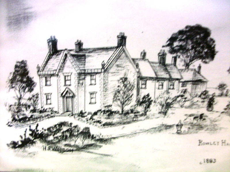
In our generally comfortable living conditions today, it can be quite difficult to imagine the conditions in which our ancestors lived and worked. These are some memories which relate to Rowley and Blackheath, so technically may be considered outside of the area of the Lost Hamlets but I am sure that many of them apply also to the houses and residents there. Some of my own memories of growing up in Long Lane and Uplands Avenue are also included.

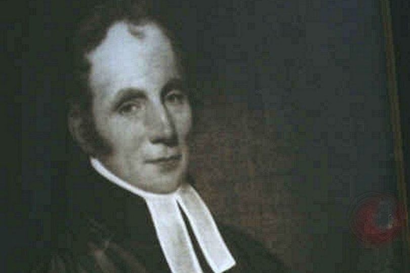
What the Vicar thought…

The Reverend George Barrs, who was Curate of St Giles from 1800 to 1840. He did not seem to have a high opinion of his parishioners and he wrote in the 1830s:-

“In 1831 the number of inhabited houses in the parish was 1366, the number of families occupying them 1420 made up of nearly 7500 individuals, an equal number of each sex, within a very few, the males predominating by only 7 or 8. 82 homes were then without inhabitants and only 5 building. Since then the state of trade has considerably improved, many houses have been built or are in progress but few unoccupied.  

Of the above number of families 140 were occupied in agriculture and 909 in manufacture, trade etc. Many however who are ranked as agriculturists are frequently engaged in some branch of trade or manufacture. A very large proportion of the manufacturers are nail makers and nearly all the women and girls; that being the chief pursuit of the operatives in this and surrounding parishes. Here chains of various descriptions and the making of gun barrels especially in time of war, find work for many hands. Here also the manufacture of Jews Harps is carried on and sometimes employs a considerable number of persons.

 A great many of the manufacturers are very poor and their families frequently appear clad in rags, and as if they could obtain but a slender pittance of life’s comforts or even necessities. This however is not to be attributed to their being destitute of the means of procuring these comforts in a degree unknown to other manufacturers but in their want of frugality, domestic economy and good management. Their work is laborious but they can generally earn good wages, which, if discreetly applied would furnish them with a comfortable competence. Unhappily however many, from their very youth contract habits of idleness and prodigality and these are a certain and fruitful source of rags and wretchedness. Since the national pest the “Beer Act” came into operation in 1830 their manners have become more dissolute, their morals more corrupt, their habits more idle and unthrifty and of course neither their personal appearance nor their domestic comforts has much improved.

Such is the degraded and grovelling condition into which many of the nailers are sunk that during the late war when wages were high those who could make a miserable living by earning 2 shillings a day would not earn another 2 pence when they might by no great exertion have earned 2 shillings a day. Of all descriptions of individuals these appear most anxious to observe to the very letter that maxim of holy writ “take no thought for the morrow for the morrow shall take thought for the things of itself” The wretchedness that results from their conduct is indeed an undeniable proof of its criminality and of the enormous evil of such perversions.”

[Note: It is likely that this statistical information is taken from the 1831 Census which is not generally available and did not include as much detail as later censuses. This information relates to the whole ecclesiastical Parish, including Old Hill, Cradley Heath, Whiteheath and Tividale, not just the village of Rowley.]

It is evident that Barr was a man of strong opinions and a striking contempt for his working class parishioners. He had married into the Haden family and apparently lived at Haden Hall, rather than in the village. The resistance he met from local people in his campaign to build a new church may have contributed to his dislike for his parishioners, but surely there must have been a few decent people? Excessive drinking was undoubtedly a general problem in those times, though not limited to the Black Country and certainly the non-conformist churches were strongly against alcohol because of the problems it gave rise to in society. And I suspect that non-conformism, particularly amongst Methodists and Baptists was already strong in the area, perhaps even encouraged by the contempt of clergy such as Barrs.

A visitor’s view of Rowley Regis

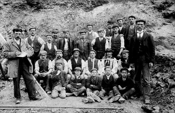
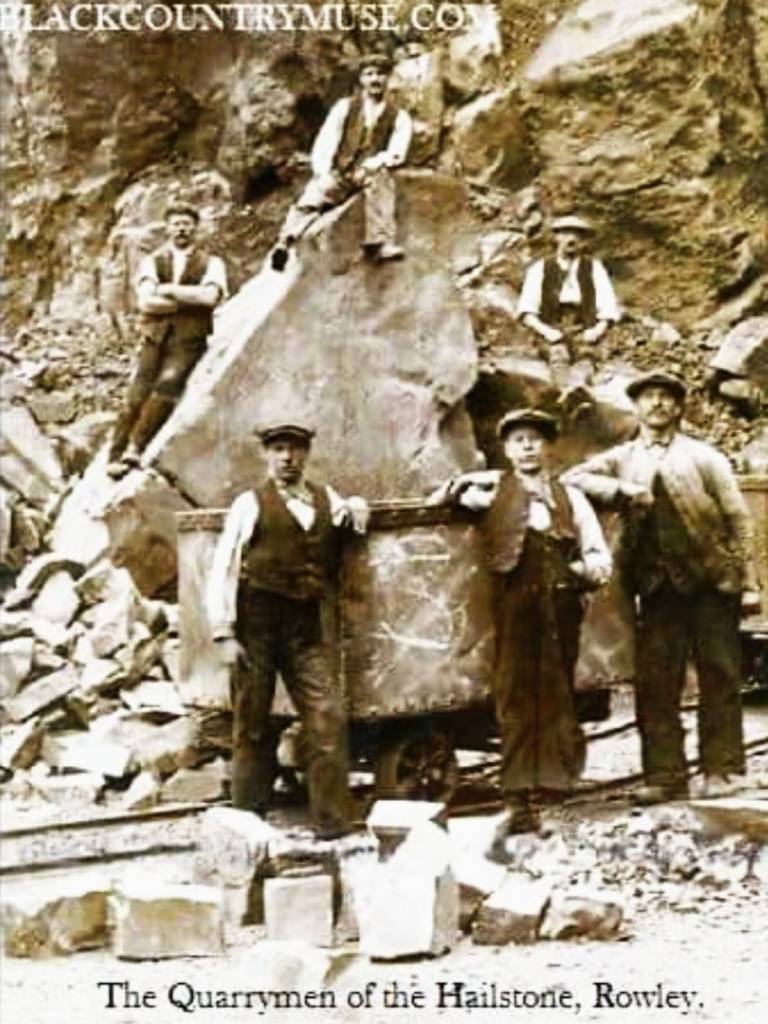
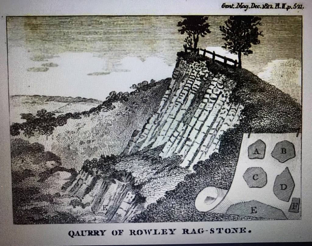
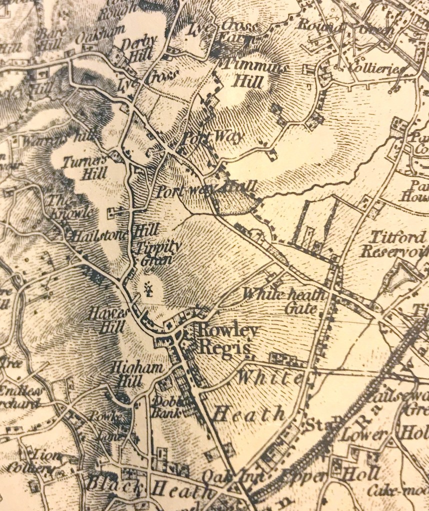
Walter White, a traveller from London, visited the Black Country in 1860 and wrote about his observations in his book ‘All round the Wrekin’ . He walked through the village of Rowley Regis and along Hawes Lane and noted the numerous quarries producing ‘Rowley Rag’. He would have seen the breathtaking view over Old Hill from Hawes Lane, a view I later gazed out at from RRGS many a time. Later he went through Tippity Green, Perry’s Lake and over Turner’s Hill to Oakham, right through the Lost Hamlets, a long walk! He also noted, echoing round the village, the click-click and thump-thump of hammers, finding that nearly every cottage had a workshop with a forge in place of a washhouse. In each workshop he and his friend observed the same scene, three or four women hard at work together, sometimes with children helping.

He noted “The fire is in common; and one after another giving a pull at the bellows, each woman heats the end of two slender iron rods, withdraws the first, and by a few hammer strokes, fashions and cuts off the nail, thrusts the end into the fire and takes out the second rod and gets a nail from that in the same way. So the work goes merrily on.”

For the women working thus, it may not have been quite as merry as he found it.

Memories recorded by Wilson Jones

In his book The History of the Black Country (now available as a reprint)  J Wilson Jones recounts that he, born in Walthamstow, had moved as a boy to Rowley Regis in 1921, following the death of his mother. He was often taken by his father to visit elderly relatives on Sundays – one born in 1839, one in 1844, one in 1845 and one in 1847 so their memories went back a long way. How fortunate we are that Wilson Jones listened to and remembered their tales and recorded them for posterity.

He tells that “One old lady had been sold as a bond servant at Halesowen Cross and had received three pence per day wages; another had been employed down the mines, harnessed like a horse and drawing tubs. They had all been nailers and had walked three miles to fetch iron, laboured 109 hours weekly for a penny halfpenny an hour, raised 11 children and saved enough to be owners of three houses. Recreational hours were unknown and children did part time work from seven years of age, school was voluntary and the majority could not read. “

Black Country houses were mostly of a pattern, and I recall that my first family home in Long Lane, my grandfather’s house in Park Street and my great-aunt’s house in Darby Street all exactly fitted this pattern. Built in terraces there was a long entry from the street to the back of the house (because the front doors were never used!)  At the rear there was a scullery or kitchen, in later years sometimes using what had been a nailshop or Brewhouse joined to the house with a bluestone or blue brick yard. There were usually two rooms up and down with a cellar below.  The lavatory was also in the yard at the rear – luxury was having a separate one for each house, often two or three or more houses shared one and people have commented on Facebook, remembering this arrangement in cottages in Tippity Green, Perry’s Lake and Gadds Green.  And a garden where vegetables could be grown and perhaps room for pig and some chickens was a bonus and not always provided.  My grandad Hopkins produced wonderful pickled shallots and grew beautiful flowers, in his garden and allotment. To this day I think of him when I see drumstick primulas which I remember him wearing in his buttonhole, in a tiny silver holder, when he visited us on Sundays.

Later, when nailmaking at home ceased,  many workshops or brewhouses were linked to the house, sometimes with a glass roof and became the scullery or kitchen, often with bathrooms or toilets later added on at the back. My grandfather’s Victorian house in Park Street, Blackheath and our 1930s house in Uplands Avenue still had cast iron ranges in the 1950s with a lovely coal fire and a kettle that could be put on it. The range in Uplands Avenue even had a little oven and I can remember my dad cooking some little lamb chops in there, they tasted wonderful. And toast made in front of the fire, using a wire toasting fork and slices of bread, fresh from the bakery in Bell End, lavished with tub butter from the shop at the top of Mincing Lane, (this was Danish butter, I think, I can remember it was cut from the block in the tub in front of you, according to how much you wanted. The shop owner could judge perfectly how much to carve off, showing long years of experience.) That toast was glorious! Toast made now with mass produced bread and toasted with electric devices doesn’t taste the same at all.

My grandparents had rag rugs on the floor, no fitted carpets in those days – from memory these were made of rags clearly from old suits and any other sturdy fabric available, hooked into pieces of sacking and warmer on the feet than lino or brick floors, though the floor in the entry and in the link from the house to the scullery was made of blue bricks. The range in our house was taken out at some point in the late fifties and replaced with a fireplace with a posh gas fire with a Baxi Bermuda boiler behind it which made the whole house warmer and undoubtedly less dusty. And yes, like many people of my vintage, I can remember ice, exquisite ferny patterns, on the insides of the (unheated) bedroom windows in bad winters, hot water bottles were an essential and when it was really cold my dad used to put his army greatcoat over the bed, it was very heavy.  

When we moved from Long Lane to Uplands Avenue in about 1957 we had an indoor bathroom for the first time – at Long Lane the bath was a tin tub which hung on the wall, filled on bath nights from the copper in the outside washhouse. There were still gas brackets on the wall at Uplands Avenue, (though disused) which had provided the lighting originally, and I remember we had a gas fridge, not something you hear of today with a tiny freezer section which just accommodated a little metal ice-cube tray. Not that we got ice-cubes out of it very often, as the freezer box accumulated frost around itself so that it usually became a block of ice itself. And your fingers stuck to the metal tray if  you tried to extract the cubes. The trick was to hold it under the tap and hope the ice-cubes came out before they completely melted!  If the little gas pilot light on the fridge went out, as it did periodically, my dad had to crawl into the space under the sink with a taper to relight it through the tiny hole at the back with a distinct ‘whoomph. Funny memories!

In most houses, including my home well into the 1960s, the front room or parlour was rarely used. In Victorian times it might have had an aspidistra, hard uncomfortable horsehair stuffed furniture, and a glass display cabinet. Perhaps a harmonium or a piano – my grandad Hopkins loved playing piano and had a white one!  I can remember my great-aunt’s middle sitting room in Darby Street had a dining table with a deep red velour cloth with a fringe I loved playing with as a child, with a lace-edged white cotton table cloth over that. My aunt could remember visiting the same house in Darby Street when she was a child in the 1920s when her grandfather still made nails out in the workshop and she could remember that she was sometimes allowed to work the bellows for the forge for him. Despite being asthmatic, he walked regularly to the bottom of Powke Lane with a little cart to collect iron rod and coke for his forge from the Gas works, and to take his completed nails to be weighed.

On one occasion, Aunt Alice remembered, while ‘helping’ her grandfather, that she had got some ashes on her white pinafore and, realising that her mother would be cross with her, my great grandmother washed, dried and ironed it before she went home. In the days before washing machines, tumble driers and electric irons, this was no mean task and speaks volumes of her kindness. My aunt also remembered that her granny was a wonderful cook and she remembered freshly baked cakes and particularly custard tarts set out to cool on the window sill. Is it coincidence that my father, myself and my son all loved custard tarts? Who knows, perhaps there is such a thing as genetic memory!

Black Country dress remained the same, probably  until the 1920s. Women nailmakers wore black lace-up boots, woollen stockings, long black skirt with a shawl , sometimes a man’s cap. Men wore checked shirts and sturdy leather belts.  The photograph here shows my great grandmother Betsy Rose and my great aunts, taken in the doorway of their shop in Birmingham Road probably in the early 1920s or thereabouts, and her dress fits this description although her daughters are more fashionable! Old photographs from the time of chapel gatherings show that many of the older ladies appeared to be still wearing their ‘Sunday best’ outfits and hats from some decades before. ‘Sunday best’ was definitely a feature of life in those days and even in the 1950s with new outfits for children for the Anniversary each year and I can remember that the men in church always wore smart suits and ties, the ladies dresses or costumes and often hats – no dressing down!

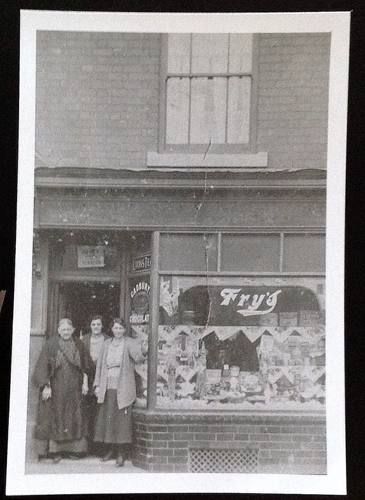
My great-granny Rose with her daughters. Copyright: Glenys Sykes

Weekly routines

Each week in earlier times apparently had routines. Monday was washday and nailmaking , Tuesday brewing and nailmaking, Wednesday and Thursday house cleaning and nailmaking, Friday ess-hole and grate cleaning, knife polishing and nailmaking, Saturday Window cleaning and nailmaking, Sunday   – preparing the Sunday dinner, church, chapel and Sunday school – no work, not even sewing! The days were long, starting at six and often not ending until 10pm. For women, all of this on top of bearing children, caring for and feeding them,  there was little time for rest. Men often worked during the day at outside jobs, in the quarry, mines or farms but also made nails when they got home.

Meals also followed a routine – Sunday, the joint, Monday cold leftover meat, Tuesday broth, Wednesday boney pie, Thursday stew, Friday faggots or tripe. What they would have thought of our supermarkets, online shopping and ready meals I do not know!

But Wilson Jones notes also that, in his words,’ Black Country people had “hearts as big as buckets”, they would laugh with the merry and weep with the sad. Neighbours would share the duties of a sick woman, share their meals, deliver each other’s babies. There was never any knocking at the door, they lifted the latch and walked in. They would draw a pint of home brewed beer for the visitor, be he a vicar or insurance agent. Brewing reached an art that no other district shared. Each home had its ‘secret’ upon how many hops or what kind of malt was to be used. The fermentation had to be produced by no synthetic yeast but from the ‘barm’ passed from one relation to another. The visitor would be handed the glass of beer after it had been inspected for clearness and he had to express his opinion that it was better than ‘so-and-so’s’  – their beer was too muddy, too sweet or too sour’.

Looking back

So – living in tiny overcrowded houses with earthen floors, no running water or sanitation, big families, polluted air, deadly diseases when no cures were available leading to high infant mortality and often early deaths, men working in dangerous jobs in mines and quarries or in the constant heat and grime of factories and the nailshop, children working in nailshops, mines, quarries and factories from the age of seven or so, few shops,  little money, little or no healthcare provision, plenty of hard work – our ancestors had tough lives, and few luxuries but often a strong faith and caring communities.  I am deeply proud to be descended from them.                                                                                                                                                                                                                                                                                                                                                                                                                                                                                                                                                                                                                                                                                                                                                                                                                                                                                                                                                                                                                                                                                                                                                                                                                                                                                                                                                                                                                                                                                                                                                                                                                                                                                                                                                                                                                                                                                                                                                                                                                                                                                                                                                                                                           

Life on the Edge

As I mention in the introduction to this One Place Study, it was the loss to quarrying of whole hamlets in which my ancestors had lived which prompted me to start this study in the hope of recording information about the hamlets and the people who lived there. Quite a few people have mentioned on the Facebook Page ‘I remember Blackheath and Rowley Regis’ their own memories of living on the edge of the quarries on Turner’s Hill.

Peter Hackett was amongst those saddened by the loss of these hamlets. He said in 2014 “You forget that Perrys Lake was almost a little community of its own. Obliterated. Fair enough you have the new houses now. You would have thought that the planners would have kept its original name….”

Marilyn Holder at the same time said “I took a drive over to see the lost community of Perry’s Lake today and found it rather sad that it has disappeared into history like so many parts of the Black Country.”  Marilyn’s  4 x Great-grandad Isaac Bishop lived in one of these cottages and worked as a nail maker in his late 70s – no pension then, work or poor house! Her father-in-law was born in one of the cottages in Perry’s Lake in 1919. She thought that there were 6 terraced cottages, which according to the 1841 census housed around 75 occupants. No bathrooms and one toilet up the back yard served all the houses.

Growing up and family memories on the edge

Cottages at Perry’s Lake, just prior to demolition, early 1960s. Copyright Linda George.

Perry’s Lake was the biggest of the hamlets and in close proximity to the entrance to Rowley Quarry in an area known as “Heaven”. The Portway Tavern was once the haunt of quarry workers after a long shift. For many years the Portway Tavern was owned by the Levett family, up to 1900, who were also butchers in Rowley and Blackheath for many years. It remained open until The Portway Tavern was demolished in 1984.

Many people have commented that Perry’s Lake was known as ‘Heaven’ though this does not appear on any maps that I have seen.

Sue Cole was born in a quarry cottage up on Turners Hill. It was next to a farm. Her mum told her that she had to fetch water from the farm as they didn’t have running water, or electricity, they had Tilley lamps for lighting. And she had to sleep in the wicker washing basket, because her brother was still sleeping in the cot. She also remembers that she used to play on the top of the quarry, and had to go inside when the siren blew when they were going to blast. When she was about six weeks old they moved to one of the houses round the back of the Tavern. Her Dad worked at the Hailstone quarry.

Carol Adney was born in Number 16 in the row of cottages along the top of Turners hill in 1950 and lived there until she was 4yrs old. 

Shirley Jordan recalled that her aunt Mary had lived in the first house round the corner from the Portway Tavern and then there was the road that was called round heaven. She used to play round heaven at the bottom and there were some horses down there. A lady and family called Onions lived round there as well.

David John Reynolds also remembered that Joe Onions had looked after the quarry horses. When David was a child in the 50’s Joe only had one horse to look after, a white one called Dolly. Geoff Skelton  noted that the field is still there where they kept the horses, the golf course fence is where the fence was to stop people  going to the edge of the quarry. Stephen Hall remembered Geoff Onions whom he had worked with at Albright and Wilson and who later kept the Portway Tavern with his wife Joan.

Eileen Hadley remembered that her great-aunt Kate Faulkner lived across Perry’s Lake, and that it used to be known as Heaven. Other residents included families called Bird and Harcourt . Jus Joan had a Great aunt whose name was Redfern, she lived in the first cottage set back from the road about half way down with a small front garden.  George Webb said that his in-laws lived at the back of the Portway Tavern, aka Heaven in old cottages ,they were Harcourts and Reynolds , both worked in the quarry. He also recalled that Syd and Joe Dowell lived opposite the Tavern . Alma Webb also remembered that she visited the cottages by Portway Tavern. George’s wife Mary used to take her to see her sister who lived there. Her husband worked at the quarry and the cottage was on the edge of the quarry.

Jus Joan had a great-uncle Jesse Plant who was killed in the 1st World war who lived at no. 12 Perry’s Lake.

Tony Holland said that he lived in the Portway Tavern from 1959 to about 1962. (It’s surprising how many people lived at the Portway Tavern at various times! I shall write a separate article on the Portway Tavern and the other pubs in the hamlets at some point!) He also knew the area as ‘Heaven’. At the end of Heaven on the left hand side was a field owned by a chap called Joe, presumably Joe Onions. The children played football there and called it Joe’s stadium. Tony said he hung about with kids from Irish families that lived there. He knew that the houses did not have electricity and relied on gas lighting. The cottages were still there in 1962 and there were about half a dozen then.

Stephanie Pullinger says that her great-grandad was a quarryman. As they lived in Tipperty Green she assumes that he worked at the Hailstone quarry but has very little information and would love to find out more. He and his brother, according to family legend, were characters. Apparently one night he brought a donkey home that he found on the way home from the pub. On another occasion he brought an old gypsy woman back much to her great grandmother’s disgust! Stephanie says that every time she thinks about that donkey she imagines its hooves clattering on the cobbles in the entry between the terraced houses.

Hailstone Quarry workers c.1910. Copyright unknown but will be gladly acknowledged on receipt of more information.

Mention of the entries between houses brought back a memory of his teenage years for David Steventon when he was helping the local milkman with deliveries each weekend. Obviously on such days one would collect payment for the week’s milk from the lady of the house. So at the front end of each entryway I would start singing, “Milk ho, milk ho, milk ho, ho, ho!” And sure enough, when he reached the back door the customer would be waiting with purse open to settle the debt.

Reg Parsons was born at Number2 Turner’s Hill in the bungalow his father had built after demolishing some old cottages which had stood on the site. He recalled Slim’s sweet shop which was the nearest shop and his parents’ shop in Doulton Road. He remembered Vera Cartwright with her milk cart. Amongst the local  boys he had played with were those from the Simpson, Parkes, Robinson and Hopkins families who lived nearby. During WWII the field below the bungalow was used as a fuel dump, which consisted of concrete bases with piles of Jerry cans of fuel, securely fenced! There was an anti-aircraft gun nearby, near the Wheatsheaf Inn, something my late mother had also told me about. Reg’s brother Harry was in the Grenadier Guards and his sister Edna was in the Land Army, based in Evesham.

I have recounted elsewhere that Reg went to Britannia Road school and milked the cows at a farm on the way through Rowley, walking to and from school. From what Reg told me about where the bungalow was, I believe this was later replaced by a much bigger house by a local motor dealer Sid Riley who owned the Garage in Dudley Port, Caldene Motors. His niece Maggie Smith tells that he had a swimming pool in the basement of his house, which flooded the rest of the house, when quarry blasting damaged the footings. 

If I am correct, this would have been the view from Reg and later Sid’s home.

View from top of Turner’s Hill. Copyright Catherine Ann.

Joyce Connop remembered that when she used to walk across Tippity Green (73 years ago!) to Doulton school there was nothing on the right hand side, only Ada’s cafe then she would cross over the bottom of Turners Hill. There  was a row of houses, one had a shop in the front room, on the other side there were the grey looking council houses then and Stiffs concrete works, Portway Tavern and a row of terraced houses lay back where the golf range is now. There were a about half a dozen houses just round the corner from Ada’s cafe at the bottom of Turners Hill which were really old, Joyce remembers her mother saying they had earth floors. There were also about half a dozen terraced houses on the corner opposite the Bulls Head.

Joyce loved Ada’s café, Ada used to serve them with penny cakes on our way to school . She was seven, and remembers that it was lonely across there and no pavement then, noting that 7 year olds don’t walk all that way on their own to school now .

Playing on the edge

There were lots of places for children to play and have fun as with so much  of the derelict land in the area, known as the ‘quack’, the ‘bonk’, the marlholes which abounded in the area.

Many children played around the quarries and some could remember falling over the edge.  Pam Veal said that she fell off the top on to the ledge once. 

Peter Greatbatch remembered in about 1965 when he was about 13, that he fell down the Hailstone quarry from top to bottom after climbing down it after a paper jet. He walked away, through the lorry entrance, with a sprained ankle and a cut at the back of his head, neither of these injuries serious! His brother David Greatbatch was there and also his friend Raymond Knowles who said to him after the incident “I thought you had had your chips there”.  Peter says he will never forget it, the luckiest day of his life. Some years later, he added, he had another incident at the other quarry at Turner’s hill in the 70’s when he hit the big rocks put by the side of the quarry at the bottom of the hill. He was trying to broadside his Ford 1600E there in the snow. If those rocks weren’t there he and his three passengers would have ended up in that quarry. He says he would not have walked away from that one.

There was a pool at the Blue Rock quarry where David Wood and JJSmith used to fish, JJSmith commenting that he fell in more than once – the sides were very steep where the perch were and David Wood agreed that the sides were so steep you were lucky if you got out. Joyce Connop recounted that her brother had fallen in there when he was 10 and another lad got a lifesaving award for getting him out.  Roger Harris remembered that he and his mates used to swim there, they used to make rafts out of old wood. One of his mates had a deep gash on his leg after hitting a sharp rock when he fell off an old bit of wood, noting that these were mad days in the 60s before such places were fenced off. There was little mention of Health and Safety in those days.

Sadly, not everyone who fell in got out. There were tragic memories of two brothers who drowned there, within living memory. It was believed that the younger fell in and his older brother jumped in to help him but neither could swim and both were lost, devastating their family and no doubt worrying legion mothers who urged their children not to go near such pools.

Riding on the Edge

Many people remembered riding lessons at Hailstone Farm. Ian Davies recalled that the Cartwrights ran Hailstone Farm which was off to the left on the way up Turners Hill.  They were his relatives; his Geordie grandfather lived with them at Lamb Farm, near Portway Hall, when he first moved south in the early 1900s. By the 1950s George Cartwright had moved away to a farm near Bewdley and Hailstone Farm had been taken over by their daughter Vera and her husband George Thomas. George taught him to ride. The quarries were already threatening to swallow the farm back then. The narrow track from Turners Hill had quarries close on both sides. The farmhouse and top of the land were later swallowed up by the Tarmac mega-quarry.

Hailstone and Freebodies Farms, on the edge! copyright D Morris

Driving on the edge

The road between Perry’s Lake and Oakham, going up Turner’s Hill also had memories for many people. This was later closed and quarried away. There was a sheer drop on either side within a few feet of the road. Many people could remember walking up that road on their way to visit family. Roy Martin could remember when it was still open to two way traffic when he first drove up there. But being narrow with passing places, it was still dodgy so they made it one-way it uphill. But as John Packer remembered, a few people still used it as a short cut, as late as autumn 1968. Michael Bowater recounted that he just managed to escape serious injury walking up there one night on his way back from Brickhouse. A car coming up the hill was going too fast and he just about scrambled up the bank on the left, it was a close call, he noted, it was a good job he was young ,fit and agile. John Packer hoped the car wasn’t his red Hillman Imp!

This photograph shows the three main quarries with the Turner’s Hill Road, climbing between the top two roads. Note also the steep edge of the bottom quarry immediately behind Tippity Green.

Eileen Herbert could remember driving up Turners Hill with her dad to visit her aunt Rose Kite, Eileen lived in Highmoor Road and the siren before blasting was very loud from there. They always knew what time was as they could hear Lenches ” Bull” as well. “Long time ago but I can still hear them in my head!” 

Angela Kirkham also recalled going to visit her gran, auntie and cousins (Tonks and Madley were the names), they used to visit on Sundays and always went over the quarry. She recalls that she spent most of her early childhood playing round the top of the quarry and the banks, sometimes with her brothers throwing bricks at other kids and sometimes at one another ! Angela’s Kirkham grandfather, father and uncles all worked in the quarries, they lived in Dane Terrace and Angela remembered that the blasts used to shake the house. These were presumably the Kirkham brothers Brian and Clifford who commented on the Facebook page that they all worked in the quarry, bringing the rock to the crusher or as a mechanic. Roger Harris also worked with them and said that, although the work was hard and the money wasn’t good, they had some laughs. Which sounds like a lot of life in the area!

Dropping off the edge

Not only people fell into the quarries. Gardens did too and other things! The map shows clearly that the quarries came right up to the edge of gardens in the hamlets.

1st Edition OS Map extract, Copyright David and Charles.

Graham Evan Beese recounted that his grandparents lived at number 50 Tippity Green until the bottom half of the garden fell down the quarry, pigs chickens and shed too. There is no word on the fate of the poor livestock! Graham’s grandparents were quickly moved to Eagle Close on the Brickhouse Farm estate.

Andrea James had a similar experience and recounts “We used to live along Tippity Green and our garden backed right onto the quarry , with only a tiny wire fence that , as children we could easily climb over. Every time they blasted we would lose a little of our garden.

In those days we didn’t have an inside toilet, ours was at the top of the garden and one morning I went to go to the loo …only to find out it had disappeared.  

To add insult to injury I had a further telling off from mom when I woke her up to tell her the toilet had fallen down the quarry.”

Andrea added that, unlike Graham’s grandparents, her family were not rehoused after losing their loo, they used Mrs Faulkner’s loo next door for years!  They stayed there until the row of terraced cottages were destroyed by a fire that started in the sweet shop . Their roof caught fire and Andrea’s father woke them all up to get out … her  mom said “Oh my God ..where’s the dog ? “

Andrea’s dad said “He’s in the car with my fishing rods”. Andrea’s dad clearly had a good grasp of his priorities. They lost everything in the fire (except the dog and the fishing rods, of course) but her mom refused to move into the horrible maisonette she was offered so they lived in the burnt out shell, with help from local people, until they were offered a better house. Tough Black Country folk, these!

And if your garden didn’t fall into the quarry, it was still a risky place to live! Paul Pearson remembered when the air brake failed (or forgot to be put on) on one of the quarry wagons, and it rolled back down the driveway, across Portway road, down the gardens and into two houses. He said that there are still steel girders out in the front of the houses now that the quarry put up after this incident.

Working on the edge

As can be seen from all these memories the quarry loomed large over the village and especially the hamlets. Many local men and boys worked there, quite a few died there or were injured or maimed.  Sarah Preston recounted that her great grandfather died in an accident there before her grandmother was born, he had done an extra shift to get extra money but didn’t live to see his daughter born.

There was regular daily blasting to loosen rock. Apparently when the blasting happened the workers sheltered under metal containers to save coming up away from the area.  Anyone who lived or went to school within hearing distance of the quarries can remember how the day was punctuated by the regular sound of the siren at 10am and 1pm. Certainly I can remember it from my days at Rowley Hall Primary, although I do not remember it from my days at RRGs in Hawes Lane, perhaps the school there was that much lower down and on the other side of the hill. Recollections may vary, others may remember it from there, too.

Maggie Smith also notes that her son in law’s father owned a cafe in Low Town, Oldbury, called the Polar Bear. The cafe had to be pulled down to make way she thought for the magistrates court. It was taken in one piece and used as the cafe at the Hailstone quarry.

Many members of the ‘I remember Blackheath and Rowley Regis’ Facebook page have told of their memories of the sirens and the blasts. The blasting was not always without incident. Alan Homer recalled a rock coming through the roof of Toyes chippy on Dudley Road. Someone else (sorry, I can’t find this entry now!) remembered a rock coming through the roof of a toilet, just after she had finished cleaning it. Fortunately it was unoccupied at the time!

Kelvin Taylor noted that his family lived in Limes Avenue, a mile away below Britannia Park  and could hear the siren and the blast if the wind was blowing in the right direction.

Graham Lamb remembered that his mother used to go mad because they had metal window frames and the blasts used to crack the glass, nearly every week his dad had to put a new pane in somewhere.

I have tried to gather these memories into a more or less coherent form and hope that people will enjoy reading about the life of the ordinary working people who lived in the Lost Hamlets. They had full, active, hard working and hard playing lives and formed strong communities. Though their physical homes have gone, something of their lives is recorded through these memories.  Please feel free to contact me if there are more memories of family here that you would like to add.

The Granite Connections 2 – The Bedworth and Nuneaton Connection

Another place which appears from time to time in all of these quarrying communities as place of birth is Bedworth, near Nuneaton. I had noted some time ago from my own family history research that Nuneaton and Bedworth seemed to have various links with Rowley Regis. So, who shall I choose to look at with Nuneaton connections?

‘The Squire’

John Beet (1775-1844) who lived at Rowley Hall in the early 1800s and was known in Rowley as ‘The Squire’ was born near Nuneaton in 1775. I have a head start here as he was my second cousin 6xremoved, so I have already done quite a bit of research on him.

Rowley Hall 1893, Copyright unknown, drawing thought to be by H R Wilson, if details of Copyright are known please let me know.

In his will, proved in 1844, John Beet  left legacies to his cousins and family in Nuneaton in the event that his only daughter Elizabeth died childless (which she subsequently did. Her Clergyman husband contested the Will to try to prevent a substantial legacy going to the grandchildren of John Beet’s cousin but was unsuccessful, John had made very specific and unmistakeable provision for £3,000 to go back to his Nuneaton family although Rowley Hall and the mineral rights passed to the son of the clergyman by his first wife; he never lived there). John Beet’s Will makes it clear that he already had a substantial income from coal mining by 1844 and he disposed of his coal mining rights very carefully.

John Beet and his family have an impressive tomb still surviving in St Giles’s churchyard.

The memorial on one side of the Beet Tomb. John’s sister Elizabeth and her husband are also buried in this tomb and also his daughter Elizabeth, although apparently not her husband.

There have been a couple of mysteries for me about John Beet. First, how did he come to settle in Rowley Regis? His parents Thomas Beet and Sarah Dunn were married in Feb 1744 in St Philips in Birmingham. John was from and presumably raised in Witherley in Leicestershire.

I say presumably because John and his sister Elizabeth were the only two children of their parents, both baptised in Witherley but orphaned when John was six and his sister five.  I have the Wills of both John’s father and grandfather who both died in 1761 and both left what appeared to be substantial property to the two children. Thomas Beet Senior, John’s grandfather, describes himself as a Yeoman in his Will and left John  “my house and land situate and being in the parish of Halesowen in the County of Worcester now in the tenure of Cottrell together with all outhouses, edifices, buildings, Barns, stables, Yards, gardens, orchards, Backsides Homesteads, trees profits and appurtenances whatsoever thereunto belonging or in any wise appertaining. My will is that my grandson John Beet aforesaid take possession and enter upon the aforesaid estate when he arrives at the age of seventeen.”

It sounds as though it was a very substantial farm. So there was a first indication of connections not far from Rowley. Plus he  left John another house in Bond End in Hinckley, Leicestershire.

John’s father Thomas, who died a few months before his father, described himself as a Husbandman in his Will, (which is defined as a farmer dealing with animals), and had also left him his own farm in Witherley, again to take possession when he was seventeen – which would have been in 1792. His sister was also left substantial bequests, including a house and all of Thomas Senior’s domestic goods which again would come to her when she was seventeen, in 1793. In the meantime trusteeship and guardianship of John and his sister appears to have been vested in Richard Beet of Nuneaton, who was a cousin and Benjamin Kirkby who I think was John’s  brother-in-law.

So where was Sarah Beet, John’s wife and mother to the children? There was no mention of her in either Will so it seemed likely that she was dead. Or perhaps she had run away, never to be spoken of again? She was certainly not buried in the Witherley area at that time, where both Thomases were.  And she had been married in Birmingham but that could cover many surrounding places. There was no formal registration of Births and Deaths before 1837 so you are looking for burials, or possibly a Will. But a will would be unusual for a young married woman.

So, whilst writing this article, I decided to try one resource which I was not familiar with when I last looked for Sarah’s burial. I searched FreeREG. (This is slightly ironic as some of my readers will be aware that I have been transcribing Rowley Regis and Blackheath church registers for the last couple of years for FreeREG.) So I entered the dates of daughter Elizabeth’s baptism (5 Dec 1776) and Sarah’s husband’s burial (23 Apr 1781) – such a short period, only five years. I searched the whole country. There were only two entries found. One was in Sheffield, not very likely, I thought, no known connections with that area. Then I looked at the second entry. St Giles Church, Rowley Regis. Sarah was buried in Rowley Regis….. and I was then able to find a baptism of a Sarah Dunn, also in Rowley Regis. (Not transcribed by me, I’m pleased to say, I surely wouldn’t have failed to make that connection had I transcribed the record!! ) There was a loud clunk in my brain as various things dropped into place – that was John Beet’s connection with Rowley, it was his mother’s home.  I have a new line to explore! 

I wonder whether John and his sister may have been less than popular with their Nuneaton cousins, with whom they were probably brought up.  The family seems to have practised primogeniture, the eldest son got all or most of the land and property which might account for other branches of the family being poorer. Thomas Beet the elder, having made very generous provision for John and his sister, left twenty shillings each – £1 – to each of his other grandchildren in the Nuneaton area, a very nominal sum. 

 Elizabeth Beet had apparently moved to Rowley with her brother John and she married William Sprigg a Gentleman of Dudley, at St Giles on 11 Apr 1799, when she was 23 so presumably brother and sister were already established in Rowley by then.  When the Enclosure Act went forward in 1807-1808, John Beet, of the Hall Farm, was relieved of manorial dues under that Act and, giving his occupation as ‘butcher’ he purchased land at Whiteheath, adjoining his existing property.  He married a local girl Sarah Higgs in 1818, before starting mining and quarrying on his property sometime later.

But John’s Beet family in Nuneaton and Weddington were graziers, people who raised and traded in cattle, an occupation which often includes farming or the butchery trade or both. As graziers and drovers they would travel round the countryside, buying up cattle, taking them back to their own farms and then fattening them ready for slaughtering and butchering. This may have been why Thomas Beet Senior owned a farm in Halesowen, to raise cattle there. The Beets may not have been the only graziers in Nuneaton, there was a Graziers Arms there, now demolished but sited on the Weddington Road, next to the railway station where probably they moved stock by rail once the railways had been built. Presumably as graziers they had their known routes and regular suppliers. Nuneaton would have been well placed, near to centres of population in Leicester, Coventry and Birmingham. Another branch of his family later settled in Coventry where they were butchers and poulterers, all in the butchery trade. Nuneaton had easy access to farming country and excellent transport links, situated just off Watling Street.

This 1841 map, copyright unknown, appears to be based on the Tithe Map and shows that although Nuneaton had a long main street and appeared prosperous and busy, it is surrounded by pasture, perfect for raising cattle.

There was another Beet living in Rowley, in Tippity Green, my 4xg-grandfather Thomas who was also born in Nuneaton in 1764 so was a few years older than John Beet. He also moved to Rowley Regis, probably twice. I was not sure, at first, whether there was any connection between Thomas and John Beet because certainly their stations in life were very different, wealthy squire and labourer/pauper. In 1841, 1851 and 1861 Thomas was living in Tippity Green, probably in the Poorhouse there.

There is a Removal Order from the Poor Law authorities in Nuneaton in 1820 relating to Thomas who was widowed and his two young sons who were deemed to have no Right of Settlement in Nuneaton, that is they were not entitled to go into the workhouse there or to parish relief and they were removed, sent to Rowley Regis. (Many thanks to my fourth cousin Margaret Thompson for sharing this with me, Thomas’s son Joseph was our mutual ancestor). The reason for this settlement decision is unclear as Thomas was born and married in Nuneaton and his sons were born there. One reason might be that he had previously lived and worked in Rowley which meant that the Poor Law Authorities in Nuneaton could repudiate him when he fell on hard times.  He died in the Poorhouse in Tippity Green in 1852, aged 88 and was noted in the Census as being blind.  But it seemed such a coincidence that both came from Nuneaton. It took a lot of digging amongst records and sideways clues but in the end I was able to confirm that Thomas and John Beet were second cousins.

They must, in a village the size of Rowley, have known each other, even if John Beet, for all his wealth, made no specific provision for his cousin in his Will. I have wondered whether Thomas worked for John Beet at an earlier date which might account for him losing his settlement rights in Nuneaton.  Thomas’s son Joseph was living in Spring Row which was the row of tied cottages behind Rowley Hall in 1851 and 1861, working as a labourer, so perhaps Joseph also worked for the Beet family, John Beet’s widow continued to live at the Hall after her husband’s death, until her own death in 1861. But John Beet’s line died with his daughter, whereas his cousin Thomas’s persisted for much longer. Beet Street in Blackheath may have been developed by John’s widow, who gave her occupation as ‘owner of houses’ and certainly some of Thomas’s descendants lived in Beet Street for some years.

However, in his Will, John Beet made the following bequest:

“I give and bequeath unto the clergyman of Rowley Church and the occupier of Rowley Hall for the time being the sum of three hundred pounds. And it is my wish and I direct them to nominate and appoint under their hands in writing six proper persons to be trustees jointly with them for the purposes hereinafter mentioned, that is to say: Upon trust to invest the said sum of three hundred pounds upon freehold or governmental security and to crave the interest and proceeds thereof and give and divide the same unto and between such poor persons residing in the parish of Rowley as they or the major part of them shall consider fit and proper objects for relief, part in clothes and part in money. I hereby direct that the clergyman and occupier of Rowley Hall for the time being shall in case any or other of the said trustees to be appointed by them shall die or refuse or become incapable or unwilling to act are to appoint other trustees or trustee in the place of the trustee or trustees so dying or refusing or becoming incapable or unwilling to act so that with the clergyman and occupier of Rowley Hall there shall always be eight trustees.” Perhaps John Beet had his cousin in mind when he made that provision. I have not found any reference to this Trust anywhere else so have no idea whether it was implemented, amalgamated with another Trust or, at some point, wound up.

I was also interested to note that one of Thomas’s sons Daniel was recorded as a ‘Horse Doctor’ and as a horse dealer in Quinton and then West Bromwich in later years, carrying on the family association with the trading of animals.

Other Bedworth connections

But in looking at these migrations for work, I have discovered more things in common for Bedworth/Nuneaton and Rowley Regis – Bedworth was the site of large stone quarry, with dolerite amongst the rocks found there – more quarrymen!  Industries in Tudor Nuneaton included leather tanning and brick making. From the mid-16th century, there was also an ironworking industry. Furthermore, although coal mining began in the Nuneaton area as early as the 14th century it boomed in the 17th and 18th centuries. And there were coal mines in Bedworth, too. Did Thomas come to Rowley to work in the quarry or a mine? Did he move with John and Elizabeth or was he here first? Was he blinded here in an accident or was it simply a medical condition such as cataracts? I shall never know.

In the 1851 Census, 78 people living in or within 5 miles of Rowley Regis gave their place of birth as Bedworth and 101 as Nuneaton. Many of these lived in the Dudley, Tipton and Tividale area.  John Darby, 49, Engineer lived at the Brades and gave his place of birth as Oldbury so he was not far from home. But his wife Jane was born in Blaenavon, South Wales and also in his household was a May Darby, a widow of 73, perhaps John’s mother, who was born in Bedworth. What do these three places have in common? Ironworks!

Job Millichip, aged 51 was living in St James’s Terrace, Dudley, he was an iron stone miner, born in Bedworth but his wife and all of his children were born in Dudley. 

Two women Susan Darby and Mary Haygill who were in Dudley Road described their husbands as Boatmen, presumably away from home on the night of the census and both women gave their place of birth as Bedworth. Canals would also have been an easy link between the Nuneaton/Bedworth and the Rowley area. Certainly in the 1861 Census, Joseph Eaton, in Hurst Lane Tipton, gave his occupation as a boatman and his place of birth as Manchester. But his wife Harriet was from Worcester and their son Joseph, aged 2 was born in Bedworth. Those with boatmen ancestors, including my husband, know well that when families lived on the boats, children could be born anywhere on the canal and river systems!

I was interested to see that two men Thomas Arnold, 24 and Henry Beasley, 37, listed in Tipton in the 1851 census gave their place of birth as Nuneaton and both were hairdressers, not a common occupation locally. Henry’s son George, aged 15 was also listed as a hairdresser, also born in Nuneaton. 

There were other Beasleys who came from Nuneaton in the 1861 Census.  Another Henry Beasley, aged 29 was living in Lye Cross, close to the Rowley and Oakham quarries, and he was a Stone Cutter. His wife Elizabeth, was a ‘riband weaver’ and their three children under six were all born in Nuneaton, so they had probably moved here recently.  Their boarder John Lilley, 47, also a stone cutter was also from Nuneaton. A visitor Mary Lilley, perhaps John’s relative, was from Wolvey near Nuneaton and was also a ‘riband weaver’. Coventry, only a few miles from Nuneaton, was well known for ribbon weaving – another skill on the move!

In the 1861 Census, 60 people living within 5 miles of Rowley gave their place of birth as Bedworth and 113 more as Nuneaton. Most were coal miners or stone cutters, this time many of them were in West Bromwich. In Tipton, John Butler, aged 60, was a ‘Pork Dealer’, another instance of the meat trade originating in Bedworth.

By contrast, only a handful of people living in Bedworth and Nuneaton in 1861 gave their place of birth as Rowley Regis. Familiar Rowley names – Enoch Hipkiss, 22 a nailer; Jesse Parker, aged 15, born in Rowley but son of a coal miner born in Bedworth; Benjamin Baker, 49 and his son David aged 14, Captain and Boat Boy respectively of a canal boat called ‘Industry’, more evidence for the existence of a canal link;  Josiah Whittal, aged 50, a whitesmith. In Nuneaton, John Smith, 16 year old was the Rowley born son of a Colliery Clerk born in Sedgley.

So a familiar pattern emerges, though not as pronounced as with Mountsorrel, of workers moving from Bedworth and Nuneaton to the Black Country for work, marrying locally and then often moving on or moving back. Two members of the ‘I remember Blackheath and Rowley Regis’ Facebook page have already told me that members of their family moved to or came from Bedworth/Nuneaton.

As I transcribe more censuses I may revisit this topic if any more of interest emerges.

The Clergy Connection

And there is one more link between Rowley and Nuneaton. The Reverend George Barrs, the notable Curate of Rowley Regis from 1800-1840, was also born in Caldecote in 1771, four years before John Beet. Caldecote is 2 miles north of Nuneaton and less than three miles from where John Beet’s family lived. 

Copyright unknown.

A coincidence? Perhaps! Might they have been at school together? There may be school records somewhere, I shall investigate. There is a family tree online for George Barrs, I shall also look at that to see whether I can find any links to the Beet family. Might the Squire have had some influence in the appointment of the curate and chosen someone he knew of from home? It does not seem unreasonable.

One more post to come on people moving for work – to Threlkeld in Cumberland, definitely connected to stone quarrying. But I have more research to do on that so it will not be for a while. Again, members of the ‘I remember Blackheath and Rowley Regis’ Facebook page have already mentioned this in comments, any further information would be very welcome.

The Granite Connections 1 – The Mountsorrel and Shropshire Connections

I have noted from Census entries for the Lost Hamlets over several decades that while most residents were from the village or the hamlets themselves, some people came from other areas. If a place recurs several times when I am transcribing, I look the place up to see whether I can work out the link and I often find that these places had granite quarries, just like Rowley.  Researching around this theme, I have found so much information that I am splitting the results into three posts.

To illustrate this migratory pattern, I have concentrated initially on looking at one family, the Hopewell  brothers who came to Rowley from Mountsorrel in Leicestershire, fifty miles away, in about 1841. There were numerous other migrant workers but I picked this family because there were three brothers to work on. I do not appear to be related to them, at least so far!

In the 1851 Census Thomas Hopewell (aged 30) and his brother Charles (24) were living in Tippity Green, probably lodging at the Bull’s Head. They both gave their occupation as Stone Cutter and both were born in Mountsorrel, Leicestershire. Thomas had already been living in Tippity Green in the 1841 Census, but the 1851 Census is the first which actually shows the place of birth, usually County and place. The 1841 Census does not show relationships within a household and just says whether someone was born in the County or not. In Rowley’s case, this means that someone could be born as close as Dudley, parts of Whiteheath or Gorsty Hill, Oldbury or Halesowen and still tick No so this is not a good indication of how far people had moved.

Thomas Hopewell had married Mary Trowman on 18 Sep 1843 at St Giles Church. His occupation then was given as a Stocktaker, perhaps at the quarry but there is no way of knowing for sure.  Mary gave her abode at the time of the marriage as Club Buildings and she was the daughter of Benjamin Trowman, a Jews Harp Maker. Thomas signed the Register so he was literate, as presumably he would need to be as a Stocktaker but Mary made her mark as most people in Rowley did at the time.

The marriage registers tell us that the father of the brothers was Septimus Hopewell and his occupation was given as a ‘Frame work slitter’ who does not appear ever to have moved from Leicestershire.  That would have been a very unfamiliar occupation in Rowley, and I think he was actually a frame work knitter. The framework knitting trade was common in Leicestershire and Nottinghamshire, making stockings but, like nailmaking, work at home which was very badly paid which is perhaps why Thomas and his brothers sought other employment. I have put a link at the end of this article to an interesting website about the conditions of Framework knitters.

There was at least one other Hopewell brother in the area, George Hopewell who married Mary Ann Masfield/Masefield in Rowley in 1842. George was also living in Tippity Green at the time of the marriage and was also a stone cutter. He died aged 47 in 1862, leaving his widow with his stepson. They do not appear to have had any other children.

Charles Hopewell, the youngest brother I have found in Rowley,  married Elizabeth Lowe in St Giles in 1852 but died aged only 32 in 1860 leaving his widow with five young children. Lowe is another Rowley name which will recur in this family tree. The children from Charles’s marriage appear to have stayed in the Rowley/Blackheath area although their mother had at least two more children and then remarried in 1870 to John Brooks, living almost next door to the Gadds in Ross. The Hopewell name in this part of the family appears to have been spelled as Oakwell in various records for some time, a hazard to the illiterate (and to the family history researcher)!  If you say Hopewell and drop the ‘h’ you can hear how that might happen. Later some of the children used the name Hopewell and some Oakwell and some swapped between the two…

Both George and Charles Hopewell were buried at St Giles.

In 1861 Thomas and Mary were living in Hawes Lane, Rowley with five children:  Annie, born 1844, Sarah, born 1847, George born 1850, Elizabeth born 1853 and Septimus born 1860, all in Rowley Regis. He was now described as a Stone Cutter.

Living next door to them were Joseph Lowe and his sons including Samuel, then aged 20 and Joseph, aged 18, both of whom feature later in the Hopewell family story. Thomas and Mary’s eldest daughter Annie married Samuel Lowe in Dudley in May 1861 and they stayed in Rowley for some years after her parents moved to Shropshire although her later children were also born in Shropshire.

Mountsorrel in Leicestershire, where the brothers came from, is described even today as ‘The village renowned for its granite quarry, the largest in Europe…  and the local area is built on granite. Organised quarrying of the granite in Mountsorrel Quarry began in the late eighteenth century, and the quarrying trade had around 500 employees by 1870.’ So there was certainly expertise in granite quarrying there.

Clee Hills, Shropshire:

There were apparently numerous granite quarries around the Clee Hills in Shropshire at this time, most of which are long closed now. Interestingly, there were a few Hopewells living in the area in the 1841 and 1851 censuses but I have not been able to link them to the brothers.

This map shows the locations of Mountsorrel in Leicestershire, Bedworth in Warwickshire, Rowley Regis and Cainham in Shropshire, all places which had a notable interchange of workers and their families.

Copyright Google maps.

By 1871 Thomas, Mary and three of their children were living in Cainham (now Caynham), Shropshire, thirty three miles from Rowley.

Most people in earlier censuses in Cainham were involved in agriculture but by 1871 there were many stone cutters, most of them incomers.  There is no mention of a quarry at Cainham in current information online about the village but in the 1871 Census there was a Quarry House and ‘The Stone Inn’ in Cainham, which are pretty good clues that there was a quarry operating then.  Quarry House was occupied by  a Quarry Man, his two lodgers were from Leicestershire – one from Mountsorrel and one from Sileby which is a nearby village, both stone cutters.

Next to the Stone Inn were the ‘New Buildings’, eight or nine houses, presumably built specially to accommodate incoming quarry workers,  as  six of these were occupied by stone cutters or sett makers, mostly born in  the Mountsorrel area  of Leicestershire, one from Bedworth in Warwickshire  plus a Clerk of Works who almost certainly also worked at the quarry. Amongst these were a sprinkling of wives and children from other granite producing areas, including several who gave their place of birth as Rowley Regis.

A few doors along the street from the New Buildings Thomas and Mary had living with them their sons  George aged 20, Septimus aged 11 and Benjamin aged 7. All the children were born in Rowley, plus two boarders.  Joseph Bissell, a familiar Rowley family name, aged 20, listed as from Staffordshire (but in all likelihood the Joseph Bissell who was baptised at St Giles on 26 Sep 1849, the son of Joseph and Mary Ann Bissell of Hawes Lane). Another lodger in their household was a Thomas Baum, born in Leicestershire, the Baum name recurs later in the Hopewell family history, too. Thomas Hopewell, his two older sons, George aged 20 and Septimus aged 11, and their two lodgers were all described as ‘stone cutters’. 

Next door was Thomas Rudkin, also born in Leicestershire and also a stone cutter, with his wife Jane and his daughter Sarah who were both born in Rowley Regis, three further children born in Cainham and his brother-in-law Thomas Parkes and mother-in-law Mary Parkes, both born in Rowley Regis.  Samuel Sharpe, aged 22, a few houses away was also a stone cutter, he was born in Mountsorrel, his wife in Cainham. A real mixture in Cainham of Mountsorrel , Cainham and Rowley Regis origins.

By the time of the 1881 Census, Thomas and Mary, both now 60 , were still living in Shropshire but had moved three miles along the road to Hope Baggott. Their son Benjamin, now 16, was still at home and their son George, with his wife Hannah and children Mary, aged 8, Joseph aged 6 and Anne, aged 2 were living next door. All of the men were stone cutters.

Interestingly, although George had been with Thomas and Mary in Cainham in 1871, his wife Hannah and two older children were all born in Rowley Regis, clearly in the interim George had gone home to Rowley to get married and stayed there for long enough to have two children before they all m oved to Shropshire. His bride Hannah Bissell, daughter of Joseph Bissell, lived in Tippity Green, so still in the Tippity Green area. It took me some time to find the record of their wedding in 1872, as the bridegroom’s name was recorded as Oakwell!  Was Hannah the sister of the Joseph Bissell who was lodging with the Hopewells in Cainham a year earlier? Yes, she was. What you might call close family links!

By 1891 Mary Hopewell was living in Clee Hill, Shropshire, a widow, although I have been completely unable to find a record of the death or burial of Thomas Hopewell in this period. Mary had two lodgers aged 20, Albert Varnham (her grandson by daughter Elizabeth) and James Masefield, both stone breakers.  The Masfield/Masefield/Macefield name has occurred in this family before, too – Mary’s brother-in-law George Hopewell was married to Mary Ann/Maria Masfield in 1842 so it is possible that there is a family connection here too. 

In 1901 Mary was still living independently in Cainham, still with two (different) lodgers, one of whom was born in Rowley Regis, sadly I cannot read his name but he was, as you might expect, a stone cutter.

Mary Hopewell, nee Trowman, died in March 1907, aged 88 and was buried at St Paul’s, Knowbury.

I have created a family tree for the Hopewells on Ancestry; if anyone has connections and would like to see it do let me know and I will give you a link. At present the tree is private.

I have not yet been able to trace all the Hopewell descendants although I know that Septimus Hopewell moved to Pistyll, near  Pwllheli, where he was working as a sett maker in 1881 and lodging with Daniel Baum and his family, (in 1871 a Thomas Baum had been lodging with his parents). Septimus appears to have been with his brother Benjamin in the Bradford area by 1901, both working as sett dressers. He returned to Cainham later and was living with his sister Elizabeth and her family there in 1911. He had then returned to Rowley Regis by 1921, still single, when he was living at 1 Tippity Green, as a lodger and working as a quarryman, full circle for this Hopewell! He appears to have died in the Dudley Registration District in 1930.

There are some connections with the Bradford area where some of the family worked as sett dressers at one point but I have not done a great deal of research on that. Again, the granite dressing skills, this time used in road making, are the connecting factor.

Several of the Varnham family, children of Elizabeth Hopewell, later moved to the Alnwick area of Northumberland, where most of them were sett makers! Follow the granite…

A moving pattern

So there is a pattern in the mid-1800s of stone cutters moving from Leicestershire, in particular the Mountsorrel area, to Rowley Regis, marrying local girls and having children there and then moving on to other quarrying areas.  The family patterns felt rather like ribbons intermingling on a maypole at times when I was trying to sort them out. Suddenly a familiar name would pop up again!

 It was obviously very common, even for families with several children , to accommodate and living in what were probably quite small cottages, for young single men to be taken in as lodgers, though it appears that in the case of the Hopewells they were often related or in close friendship groups.

Stone cutters were clearly not simply labourers, there are other entries in the censuses for labourers, both general and agricultural but stone cutters and sett makers, wherever their origins, are listed by their skill.

This photograph (brought to my attention by Ronald Terence Woodhouse) shows workers in the Hailstone Quarry and shows the size of some of the rocks they were working with. Imagine the effort needed to manually reduce that very hard rock down to small evenly shaped setts. Hard and dangerous work. It is also used on the front over of Anthony Page’s book on Rowley in Old Photographs and he notes that it was from the Ken Rock Collection: the photograph itself refers to BlackCountryMuse.com. Whichever owns the copyright, due acknowledgment is made!

Whether these movements of workers happened because the quarries sent recruiters to particular areas which had the skills they needed is not clear or whether word was spread by the men themselves that work was available or a combination of both. Some of these skilled workers settled in their new areas and many moved on again to another granite quarrying location where their skills would have been at a premium. If you have ancestors in Rowley who you know came from Leicestershire, or who subsequently moved to Shropshire, this may well account for it!

I will do another post about the Nuneaton/Bedworth connections to Rowley.  

And there was another migration wave, a little later on in the century , which I will write about in another piece – The Threlkeld Connection, to follow soon!

Other resources:

The Hailstone 2

It was lovely to see that my post on the Hailstone attracted so much interest. Better still, a couple of people on the ‘I remember Blackheath and Rowley Regis’ Facebook page were able to add more information which is very interesting, thank you to those concerned.

Thank you to Darwin Baglee posted this article, more about the Devil’s connection!

Copyright unknown but will be acknowledged if ownership can be shown.

Robert Faulkner added a lot of information about the legend concerning the devil or, in this case, the gods hurling boulders from Clent, saying

 ‘The story as I recall was that Thor stood upon Clent and threw a hailstone at Woden. Woden dodged the stone and it embedded in Rowley Hill. The story interested me because Clent is one of the very few place names in the area of Viking Origin. There were a lot of confrontations between Anglo-Saxons and Vikings in this area. Unlike the rest of Mercia it did not fall to the Vikings.’

Robert then found this article about the legend,  taken from an article by the great local historian Carl Chinn which appeared in the Birmingham Mail in 2008, link below.

“THERE is an ancient legend that once, when the Anglo Saxons still worshipped the old gods, Thunor, better known as Thor, bestrode the Clent Hills.

Red of hair and beard, and boasting great strength, he was the god of weather and is recalled in Thursday.

Quickly raised to anger, Thunor was a powerful deity. Wielding a mighty hammer he hurled thunderbolts from mountain peak to mountain peak when he was enraged.

The story goes that he fought with his father, Woden, who is recalled in Wednesday, as well as in the Black Country place names of Wednesbury and Wednesfield.

One-eyed, all knowing and draped in his cloak and hood, Woden strode easily across the land when the weather was fine – but when it was stormy he careered across the dark sky at the head of a clamorous wild hunt.

During the struggle between the two mighty gods, Thunor is said to have hurled a massive boulder at Woden, who had planted himself upon Turner’s Hill in Rowley.

The outcome of the terrible fight is lost in the fog of mythology, but Thunor’s boulder came to be called Hailstone and so gave another name to Turner’s Hill.”

Robert added “It is a little different to the legend I originally read, but the same basic story. It could be a folk memory of a real conflict. It was suggested that ‘Clatterbach’ Clent was named after a battle. Since the Stour there formed the Border between two Celtic Tribes, later between a Celtic tribe the Cornovi and the Saxons, then even later the Angles and the Saxon Hwicce, then there is the Viking origin of the name Clent. So there were probably numerous confrontations in that area. Thank you, Robert, very interesting.

This could take the name Turner’s Hill back even further into the mists of time, recent discussions on the Facebook page had recently indicated that the name was already in use in the 1300s.

Further research of my own has found a letter published in The Gentleman’s Magazine, in 1812 from a TH, describing a visit to a quarry at Rowley Regis. He says:

“I have inclosed to you a sketch (see Plate II) which I made a few days since. Of a quarry from whence the Rowley Ragstone is taken, of which stone this and some of the adjacent hills are chiefly composed, as it is to be found in most parts immediately under the surface of the ground. I made this sketch in profile of the quarry, to shew how the pillars inclined from the perpendicular. The situation of this quarry is at the top of a hill, and nearly equidistant from Dudley, Rowley Regis and Oldbury, not quite one mile and a half from the nearest of those places; the hill is long and steep on eah side, rising into different peaks, and their line of direction from Rowley is N.N.W;  they command an extensive view of country in every direction.

The Hailstone, which is also a rock of Rowley rag stone, mentioned by Dr Plot in his History of Staffordshire, is to the North of this quarry, distant nearly one mile. The height of some of the columns represented in this sketch are from sixteen to eighteen feet, and the longest joints of the stone are from three feet three inches to three feet nine inches; the upper and under surface of the joints are generally flat: I have represented the outline of some of t hose surfaces to shew their angular form, in a separate compartment;  their diameters are as follows: the stone A is 9 inches, the stone B 14”, C 13”, D 15”, F 9”; at E is only the part of a stone, it corresponds with E in the sketch, it is 30inches in diameter, and a part of it being hid by other columns, preventing my observing the shape of its  other angles.

Descending the hill and not half a mile distant, is another quarry of the same kind of stone, the level of which is more than 100 feet below the former; this quarry presents columns on a much larger scale; some of them appeared to me about two or three yards in diameter, more or less, as I did not measure them; they did not appear so regular as those in the upper quarry, which perhaps may be owing to the want of a sufficient excavation to display their lengths; this may lead to suppose with reference to the columns at E, that those columns increase in magnitude as they approach the bas of the hill; but this is mere conjecture. The exterior colour of the columns is of a light brown but, when broke, the inside of the stone is of a grey, or nearly black and of a close compact body. Yours etc. TH”

The quarry he was describing must have been one of the earliest quarries in Rowley. A copy of his sketch is shown here.

The sketches shown below are from a Mining Review and Journal of Geology, published in about 1837. The first shows the Pearl Hill quarry in Rowley Regis and I have seen other references which imply that this was the name of the first quarry.  The second sketch shows the Hailstone, from a slightly different angle to the previous pictures I have seen and which gives a better impression of the depth of the Hailstone. These pictures are noted as having been published in a History of Birmingham and its Vicinity.

It seems probable that the first article also describes the Pearl Hill quarry and this picture is labelled, very faintly, Pearl HIll quarry and there is some resemblance between the two pictures. Can anyone work out where this was, somewhere half a mile above the Hailstone? Perhaps the first excavations in what was later called the Turner’s Hill Quarry? Or closer to Oakham?

Another image of the Hailstone in the same journal.

An article in this journal about the geology of the Rowley Rag says:

“Rowley Rag appears in several places externally, assuming striking and bold configurations; and presents itself to the geologist in a questionable form. It is not a stratum originally deposited either above or below the limestone, for neither of these two substances is ever found to range or correspond  in position with the other.  It is obviously not diluvial, for it bears no trace in its composition of the horizontal action of water; neither is it primitive for coal is found extending beneath it. Of course, its formation, in the places it now  occupies, must have been posterior to that of the coal. The only rational conclusion, therefore, is that it was ejected in a fluid state, from the bowels of the earth, through a chasm opened by the force of elastic vapour.The action of fire is also observable in the appearance of coal which,  in the immediate neighbourhood of basalt, is completely changed in quality,; decomposed; reduced into a state resembling old exhausted coke.

In fact, careful analysis and comparison have shown that the basalt  of this district is identical with the lava which is known to issue from volcanoes at the periods of their eruptions; and the various forms it exhibits when exposed, may, probably, be referable to the greater or less rapidity with which it underwent the process of cooling. Of these appearances, the most remarkable is the columnar, so perfectly developed in the Giant’s Causeway, in the north of Ireland and distinctly, though  less regularly, discernible in some of the quarries of this neighbourhood.”

One has to remember that this was written nearly 200 years ago and that scientific and geological science has moved on enormously since then. And I have no knowledge of geology. But it is interesting to consider from this that the division of the Rowley Rag into these columns, (which are still apparent in the photograph of the quarry which I included in the last article) does bear some comparison with sites such as the Giant’s Causeway. The link below is to a leaflet published in about 2010 about Rowley Regis which has a photograph showing the columnar structure within one of the quarries. You will need to rotate the leaflet to seee the picture the right way up.

Apologies for these long-winded quotations but they do seem relevant to the formation of the Hailstone. There is even more which I have not included. It’s interesting to think that the Hailstone was an early tourist attraction!

Links:

https://www.thefreelibrary.com/Mythological+battles+and+council+housing+in+Weoley%27s+history.-a0179344570

The Hailstone

The scene our ancestors would have known in and around Rowley village would have been very different a couple of hundred years ago, it changed enormously during the Industrial Revolution and has changed again, almost beyond recognition, since I grew up there in the 1950s and 60s. One sight which would have been familiar to local people in the past was ‘The Hailstone’ on Hailstone Hill and I do not mean the modern pub bearing that name!

The Hailstone was a curious natural rock formation, comprising blocks of Dolerite stone, and was probably left with large boulders tumbled around it due to Ice Age erosion when the Ice Age retreated. It was at one time thought to be a meteorite. The Hailstone was on Hailstone Hill, above Tippity and Cock Greens and could apparently be seen clearly from Clent before the contours of the hills were destroyed by quarrying. An impression of the size can be had from the sketch  below which is based on an engraving by W W Baker in 1845.

Copyright Glenys Sykes.

Whites Directory of 1834 has this description:

“On the western side of the hills, and not far from the town, a compact mass of this stone, about 7 or 8 feet square, rises to the height of 8 or 9 feet above the summit, and from 50 to 60 feet from the base of the hill, which, from time immemorial, has been called the Hail Stone; the upper surface, though from its extreme hardness impenetrable to any tool, is worn perfectly smooth by time and the action of numberless feet of persons who have climbed upon it.

In removing one block near the Hail Stone, about 40 years since, an earthen vessel nearly full of Roman silver coins, some of which were of Antoninus and Faustina, was found deposited in the foundation of the wall. “

It was reported at the time that the pot had an opening at the top to allow coins to be posted in – a Roman piggy bank! Sadly the pot and the Roman coins were apparently removed for safekeeping and no trace of them can now be found. 

Various stories were told locally of the Hailstone, including the legend that it could not be destroyed without the spilling of Anglo-Saxon blood, or so I was told by Reg Parsons who grew up on Turner’s Hill. And when the Hailstone was destroyed in 1879, as part of quarrying operations, two workmen were killed during the process, and local people thought that they were anglo-saxon by blood, thus fulfilling the old prophecy.

Dr. Plot, in his History of Staffordshire published in 1688, describes the rock on the Rowley Hills as being “as big and as high on one side as many church steeples are.” He relates that he visited the spot in the year 1680, accompanied by a land-surveyor, who, ten years before that time, had noticed that at this place the needle of the compass was turned six degrees from its due position. The influence which the iron in basaltic rocks has on the needle was not known at that period, and the Doctor makes two conjectures in explanation of the phenomenon observed. First, he says, ” there must be in these lands that miracle of Nature we call a lodestone;” and he adds, ” unless it come to pass by some old armour buried hereabout in the late civil war.” The sonorous property of the rock led him to conjecture “that there might be here a vault in which some great person of ancient times might be buried under this natural monument; but digging down by it as near as I could where the sound directed, I could find no such matter.”

The following description appeared in “A description of modern Birmingham” by Charles Pye , supposedly in 1908. I have included some of his less flattering comments about the church and the village itself.  

“You proceed towards Kidderminster, until you arrive at the toll gate, two mile and a half distant, when the right hand road leads to this village where in all probability there are more Jews Harps manufactured than in all Europe beside.

The admirer of nature, (for no art has ever been practised here) may be gratified with various extensive and luxuriant views. There is not anything either in the church or in the village deserving of notice, but there is, not far distant, a rude rugged, misshapen mass of stone, which is situated on the summit of a hill, and projects itself several yards higher than the ground adjoining; it is by the inhabitants denominated Rowley Hail-Stone and when at a considerable distance from it, on the foot road from Dudley, it has the appearance of some considerable ruins.

From this spot the views are more extensive than can be easily imagined over a beautiful and romantic country, Birmingham being very visible.”

It seems rather odd that this description should have been published in 1908, as the Hailstone was removed in 1879. It is not often that one sees descriptions of this area as ‘beautiful and romantic’ or luxuriant by 1908, though extensive is undeniable. (The view over the valley from the top floor of the classroom building at the Grammar School below Hawes Lane was truly awe-inspiring and there were still some foundries operating at that time.) But other observers report, by 1908, the huge amount of industry, mines, quarries, furnaces, canals, railway lines and spoil heaps which despoiled most views in this area so I wonder whether this account was actually written much earlier, perhaps in 1808.

Another account appears in Stone Pillar Worship (Vol. vii., p. 383.) Date not known.

—The Rowley Hills-near Dudley, twelve in number, and each bearing a distinctive name, make up what may be called a mountain of basaltic rock, which extends for several miles in the direction of Hales Owen. From the face of a precipitous termination of the southern extremity of these hills rises a pillar of rock, known as the ” The Hail Stone.” I conjecture that the word hail may be a corruption of the archaic word holy, holy ; and that this pillar of rock may have been the object of religious worship in ancient times. The name may have been derived directly from the Anglo-Saxon Haleg stan, holy stone. It is about three quarters of a mile distant from an ancient highway called “The Portway,” which is supposed to be of British origin, and to have led to the salt springs at Droitwich. I have no knowledge of any other place bearing the name of Hail Stone, except a farm in the parish of West Fetton in Shropshire, which is called ” The Hail Stones.” No stone pillars are now to be found upon it: there is a quarry in it which shows that the sand rock lies there very near the surface.

This picture of the Hailstone gives a better impression of the size and appearance of the Hailstone within the landscape and accompanied the article above.

The artist for this drawing is unknown, Hailstone Farm is shown in the distance.

There are some other snippets about the Hailstone which I have found online, sources unfortunately not credited but included for interest.

“If you stand on the site of the Devil’s Footprints and look towards the Rowley Hills, Hailstone Hill comes into view. The Hailstone itself is long gone, demolished in 1879. The Hailstone was also associated with the Devil and was said to be cursed, there is a story that the Devil threw stones at the Rowley hills from Clent which landed on Hailstone Hill and formed the mighty Hailstone, a huge outcrop of basalt rock from which he could survey his kingdom. There are also tales of the Devils footprints being found in the vicinity of the Hailstone and the local quarries; some said it had to be destroyed because of its evil associations. When it was finally destroyed by dynamite in 1879 two men died in the process, fulfilling the curse of the Hailstone”

Here is another account of a similar phenomena.

“In the Black Country, in January 1855, cloven hoofmarks, similar to those of a deer, were found on the vertical walls and roofs of a number of pubs, starting with The Cross at Old Hill in Rowley Regis. Elizabeth Brown, landlady of The Lion pub, suggested a supernatural explanation for the mystery, telling a public meeting that ‘her house was mainly frequented by quarrymen and the tracks were nothing new to them. Similar hoofmarks were to be seen burnt into the rock at Pearl Quarry, on Timmins Hill, and trails of them led from that place to the Hailstone.’ Since the Rowley hoofmarks appeared nowhere but on the walls and roofs of pubs, however, it seems at least as likely that the Lion marks were made by local chapel ‘ranters’ who wanted to make a point about the pernicious effects of alcohol “.

So the name ‘Hailstone’ may have been a corruption of Holy Stone, it may have been used as a perch by the Devil and was regarded with awe and great superstition by local people.  Anthony Page says in his book on Rowley that it had been removed by the summer of 1879 with festivities to celebrate the event. Frederick Wright of Hawes Lane, aged 30, was killed in February 1879 in the process of uprooting the rock and Benjamin Bate, of Cocks Green, aged 41, one of the last men to bore shot holes, was killed in December 1879. After the removal of the rock, a tramway incline was made in 1880, connecting the Hailstone quarry to the canal at Windmill End.

This photograph of the Hailstone Quarry, taken in the mid-1950s, gives an impression of how the Hailstone must have looked.

Copyright : Anthony Page and Irene Harrold

What an imposing sight the Hailstone must have been, how many millennia it towered over the local landscape, it is no wonder that there were so many stories about it – but at least we have drawings to help preserve the memory of it.

The Tippity Green Toll Road – an update

Further reading on this subject has brought me to a paragraph in J Wilson Jones’s book, published in 1950. He talks about the early road system around Rowley and says

“Let us consider the early roads from the early enclosure and pre-enclosure maps, knowing that a Manor of Rowley would be connected by the earliest of roads, being the all-important demesne. Then locate the toll gate houses, not the turnpike of the busy roads, but houses where toll or tax was paid, often situated near the Lord’s Mill [which was at Tippity Green]. We have the Rowley-Dudley Road through Knowle and Powke Lane as the only marked roads, both converging upon ‘Ye Brickhouse Estate’ [which Jones thought was located at Cock Green which was between Tippity Green and Knowle] . The Toll houses are again on Powke Lane at Yewtree Gate and near Tippity Green as Tippity Green Gate. The only other land marks on the 1821 map being Freeberry’s, Hailston Hill, Perry’s Lake and Hawes Hill.”  

So my surmise in the last article that the Toll related to the new road from Perry’s Lake to Portway seems to be wrong. If Jones is correct, the Toll Road ran from an area known as Yew Tree on Powke Lane to Tippity Green, up what was then called Dog Lane, subsequently known as Doulton Road, (though I have been told that the canal bridge there is still called the Dog Lane Bridge on canal maps).

I have not been able to identify the map dated 1821 to which Jones refers.  What is now called Yew Tree Lane and the public house called the Yew Tree is much higher up Powke Lane than the road Jones describes, but Yew Tree is clearly marked at the bottom of the lane on the map below . This extract from the first edition OS map, surveyed in the 1830s, shows the road which Jones says was a Toll Road and which I have marked in red.

Copyright David & Charles

The road to Portway may well have been built later by the quarry operators to facilitate the movement of their stone, and they did, after all, have plenty of material to build it with.

Always learning…

Reference: A History of the Black Country by J Wilson Jones, published c.1950.

An unexpected bonus map!

Old maps are always interesting to me. And they can be very informative about how a place has developed. I have shown extracts from the First Edition OS map previously on this blog and also from the Godfrey reproductions of the Second Edition. Alan Godfrey is well attuned to the value of being able to compare maps over periods and often publishes groups of maps in an area and then the next edition so that development can be clearly seen and usually has offers giving a discount for buying two maps of the same area together. His maps are very good value at £3.50 and the service is brilliant, maps usually posted out on the day of ordering. He is especially good at industrial areas.  

I also have a book of Antique Maps of the Black Country which has maps dating back to 1579 but most are not very detailed. Just a very interesting book to browse through.

There are other maps I would dearly like to see but have not yet been able to find. It would be very interesting to see any plans associated with the sale of the Glebe lands on which Blackheath was subsequently built. I have occasionally seen what I suspect may be extracts from it but have never located the whole plan.

Much of the area surrounding Rowley was heath or waste land originally and, as in many areas of the country, in the late 1800s, the landowners who owned much of the land decided to seek an Enclosure Order to enclose most of it within hedges and walls, the hope generally being that this would encourage better farming outcomes. The Enclosure Bill went forward in 1799, resulting in an Act and Award in 1807-8. The effect was to parcel out about 300 acres of common pasture in 228 separate holdings and to commute some ancient manorial duties and rights. Although common people who relied on keeping their pigs, chickens and cattle on common land were probably less enthusiastic. 

Edward Chitham, my one-time Latin teacher and the originator of my interest in local history, wrote in detail in his book  ‘Rowley Regis A History’ , noting that the documents associated with this showed the names of local families. It is worth trying to read this scholarly book, with many illustrations – second hand copies appear to be rare but libraries may be able to obtain it on inter-library loan.

The two Lords of the Manor were William Viscount Dudley and Ward (Rowley Regis) and Granville Leveson Gower, Marquis of Stafford (Rowley Somery). The Vicar of Clent (of which Rowley Regis was at the time still a chapelry) was compensated for the loss of tithes by 11 acres of additional glebe land at Cradley Heath and 39 acres at Blackheath, the latter sold later to fund the building of a new church, leading to the development of the ‘new town’ of Blackheath.

Existing landholders could also buy land adjoining their own property and John Beet, butcher, of Rowley Hall bought land at Whiteheath; Richard Bate, farmer bought land at Tippity Green; Isaac Downing, nailer, bought  land at Turner’s Hill; Richard Gaunt land at Portway Hall; Stephen Rollinson, butcher, and Thomas Sidaway both bought land at Reddal Hill. Chitham notes that, of all the purchasers of land and those allotted it, only one – James Purser, lived at a distance, in London. All the rest were resident in the locality, many actually in Rowley parish.

Some papers relating to the Enclosure Act are at The National Archives at Kew and on my next visit I will examine those. Other copies may be in County or other archives but some documents arise from deposits of family papers from solicitors and these tend to be more scattered.  Driving any distance is a problem for me at the moment, due to a knee problem so I have not been optimistic about being able to see such documents and plans any time soon.

So I was delighted when Kevin James posted a photograph of part of a map of Rowley Village, dating from 1804, on the ‘oldbury and blackcountry history’ Facebook page recently. And very obligingly, at my request, he then added a photograph of the area of the Lost Hamlets on the same map and also the Inscription and the key to the colours used on the map, also kindly giving me permission to include them in this study. 

Copyright Kevin James

So this is a copy of the map which was used in the Enclosure process and reproduced, it appears fifty years later by the same artist. What a treasure! So many familiar Rowley names, some of whom were still in possession when the censuses began forty years later.

Copyright Kevin James

Copyright Kevin James

Out of interest, this is the other map Kevin posted, of Rowley Village.

Copyright Kevin James

I hope you find this map as interesting as I do. I shall continue to try to see the Enclosure Act but this glimpse of the area is very pleasing.

Useful further reading:

Copyright: Glenys Sykes

‘The Black Country as seen through antique maps’ by Eric Richardson, published by the Black Country Society. ISBN: 0 904015 60 2

‘Rowley Regis – a History’ by Edward Chitham. Published by Phillimore in 2006. ISBN: 1-86077-418-0

‘The Oxford Companion to Family and Local History’ edited by David Hey. Published by Oxford University Press in 2010. ISBN number 9 780199 532971 – an immensely useful book, used copies available for less than £5!

The Tippity Green Turnpike

The 1851 Census shows that there was a Turnpike Gate in Tippity Green. The Gate Keeper Hannah Hadley, aged 34, was listed, along with her husband Samuel (35) who was a Nailer’s Tool Maker and their nine children. If the Toll Keeper’s cottage was like most tollhouses that you see, it would have been fairly crowded, though that appeared to have been true of most houses in this area.

I was not previously aware that there was a turnpike road in this area. From the census enumerator’s route, it was at the end of Tippity Green and just before Perry’s Lake.

Copyright David & Charles.

This map is an extract from the OS First Edition, which had been surveyed in the period up to the early 1830s. The road from Tippity Green goes up Turner’s Hill, there is no road straight on to Portway from Perry’s Lake as shown in later maps, so perhaps the very straight wide road from Perry’s Lake to Portway at what became Four Ways was a new Toll Road. In which case there would have been another Toll House, presumably where it joined Portway, with Newbury Lane on the other side of the road leading on to Oldbury. It would have been a very convenient and much flatter improvement to the route, much to the benefit of industrial traffic and at least better off people would have been willing to pay a toll to avoid the hill.

Turnpikes were apparently usually set up to improve existing roads which parishes were struggling to maintain. They were roads administered by Trusts authorised by private Acts of Parliament, on which tolls were charged at gates. They first began in 1663 and gradually increased in numbers so that by 1820 over 1000 turnpike trusts controlled about 22,000 miles of road with 7000 or more gates. Mostly they followed the old roads up hill and down dale. But by the early 1800s, new turnpike roads were being planned along routes whhich had not previously existed. This may have been such a road.

I am now trying to track down more information about this, in the form of the Act of Parliament setting up the Trust or plans and documentation and have sent enquiries to local archives. This may take some little time so this is a teaser and I will keep you informed of any more information I find. Watch this space!

In the meantime, if anyone knows of any information about this turnpike, I would be very pleased to hear from you.

I have been unable to find another Toll House Keeper listed anywhere in the Portway area in the 1851 Census but it is possible that a different enumerator might have recorded only the main occupation of the husband.

It does occur to me that perhaps the new road from Springfield to Dudley might also have been a turnpike road, and, if so, there would have been a gate keeper’s cottage there, too. But that is pure speculation!


Copyright Alan Godfrey Maps

The windmill off Tippity Green, which is documented as being there for centuries, was also still marked on the earlier map, where Windmill Farm was later.

Incidentally, you can also see from this map that the road to Whiteheath from Rowley village goes past the church and then bends round in front of Rowley Hall (I am old enough to remember where Rowley Hall was!) and straight on to Throne Road and past what became known as Ramrod Hall Farm. There was no Hanover Road then. When the quarrying and mining to the North of Rowley Hall expanded it cut off this road so another route must have been found by local people who would still have needed to access the parish church for services, baptisms, marriages and burials.

Copyright Anthony Page

This photograph shows the ‘small quarry’ below Rowley Hall. No chance of walking the old route across this.

This closure must have been inconvenient for people living in the Whiteheath and Mincing Lane area but the quarrying and mining did offer work opportunities. In due course, another road was built from Mincing Lane/Bell End to the Hall to provide a road for vehicles, called, of course, the New Hall Road which is still there, now called Newhall Road.

I recall that, more than a century later when I was a child, people still cut from Bell End up the side of the ‘bonk’, over the now flattened old pit and quarry workings, past the old reservoir to come out at Rowley Hall, on their way to Rowley village and church (or school in Hawes Lane in my case) as the shortest route available. Old habits die hard!

A Methodist chapel in Perry’s Lake?!

Once upon a time there was a Methodist Chapel in or between the hamlets of Gadds Green or Perry’s Lake. Who knew? There is no trace of it on any of the maps I can find but it is listed on the censuses, between Perry’s Lake and Gadds Green , in 1861 and 1871.

I first noticed when transcribing the 1871 Census for Perry’s Lake and Gadds Green that between the two hamlets there is a line which says “Primitive Methodist Chapel”. It is not mentioned in the 1881 Census but in the 1861 Census it is there, again listed between Perry’s Lake and Gadds Green both times but this time called Gadds Green Chapel. Not mentioned in the 1851 Census (although Thomas Barnsley, aged 29, living in Perry’s Lake and born in Rowley Regis, gave his occupation as “Methodist Local Preacher and labourer at Stone Quarry”.

However, in an 1844 Preaching Plan for the Dudley Circuit which is on the ‘My Primitive Methodist’ website, Perry’s Lake is among the Chapels listed as having two services each Sunday at 2.30 and 6pm.  Also listed is Rowley  – one service each Sunday at 6pm, though it is not clear where this chapel was, possibly services held in a private house or a rented room or even the open air, as neither Knowle nor Hawes Lane chapels are recorded as having been in operation by this date.

The Preaching Plan is an interesting document, showing the burgeoning vitality of the Methodist church in those days with a list of more than 36 chapels in and around Dudley with a few paid ministers who walked long distances to conduct services and in excess of 80 local preachers in the area, including several women.  And that was only the Primitive Methodists, there were several other types of Methodists, plus Baptists, Congregationalists, Quakers, Unitarians and others all apparently thriving.

The chapel was also noted as ‘Gads Green’ on a list of Chapels, drawn up in 1867, which is again on the My Primitive Methodist website. So it definitely existed between 1844 and 1871. It would be interesting to see the 1887 OS 6″ to the mile map , just to see whether it was still there then but I can’t find this map online or in print anywhere at the moment.

The earliest 6″ OS map I have at present is dated 1904 and I can’t see a chapel marked on there in Perrys Lake or Gadds Green. There is a Chapel Cottage in Gadds Green as late as the 1911 Census but a chapel isn’t mentioned then. So I wonder whether the local Methodists transferred to other chapels, the nearest being Hawes Lane or The Knowle, both less than a mile away and surely less than a mile apart! 

I found online this bit of history about the Knowle Chapel (Eric Bowater giving the information in 2019).

“The first beginning of Knowle Methodist Church met in the small kitchen of a local house,for the sum of 1s 6d.around 1860. As the membership grew it moved into a farm building in Brickhouse Farm a short distance away. Once again the membership grew and so it was decided to build a church of their own. A Church was now to be erected on the present site and was opened in December 1869 called Ebenezer. In 1890 new trouble arose with undermining which affected the chapel. The last meeting held in the chapel was held in 1907.The present church which was built in front of the old one 25th September 1907 and was a United Methodist Church.”

The Knowle site would have been quite close to the hamlets and accessible across the fields so if the earlier chapel closed people might have moved to the Knowle chapel. Reg Parsons, who grew up on Turner’s Hill, told me that he had never heard of a chapel there but that there was also a ‘tin chapel’ at Oakham, opposite the pub there so that may also have provided a spiritual home for some local people when the Perry’s Lake chapel closed.

There was an Ecclesiastical Census on 31st March 1851 (this can be downloaded free of charge from The National Archives) but many small chapels appear to have been omitted and I have been unable to find a chapel I can identify as Perry’s Lake or Gadd’s Green. The entry for St Giles shows figures for attendance which, frankly, I find rather suspect.  An extract is shown here.

Copyright: The National Archives

I find it difficult to imagine 600 people at morning service with 400 children at Sunday School, 1100 people all crammed into St Giles Church for the afternoon service with 400 children at Sunday school (again) and another 100 in the evening in a rented room – such neat round figures, 1000 and 1500 people?! The return for Dudley St Thomas gives figures of 800 and 700 attending services but that for Reddal Hill claims much more modest figures of 149 at church with  223 at Sunday school in the morning with 259 and 223 respectively at later services.

As we have just entered the season of Lent, it is perhaps timely to note that several clergy, in their returns for this census (and clearly anxious that their attendances should not be underestimated by the powers that be for the future), pointed out that the date chosen for the Census was the middle Sunday of Lent.  The note shown below was attached by one local Clergyman. It reads “The reason that attendance at the church appears smaller on the 30th Mar than the average is that the day is Mid-Lent Sunday, commonly called Mothering Sunday. A day much observed in this district by parents having their children and friends around their tables on this day and providing the best in their power for them.”

Copyright: The National Archives

What a picture that conjures in a few words. And a clergyman apparently much in tune with his congregation, however humble.  I can remember my mother telling me as a child that Mothering Sunday was the one day of the year that domestic servants were allowed to go home to visit their mothers, often taking them gifts of food from their employers or spring flowers gathered along the way.

One nearby Anglican clergyman noted bitterly on his return, the ‘scourge of those Dissenters so prevalent in this locality’ and blamed them for his poor attendance figures – showing the hostility of some clergy to their independently minded parishioners. Nonconformists were not popular at that time with the Anglican church, generally seen as rebels and ignorant troublemakers to be corrected and brought back to the Anglican church. A history of Birmingham Road Methodist church in Blackheath recounts that their meeting started in the 1840s in a rented stable in Siviters Lane in Rowley. Dissenters, as they were known, were regarded as the ‘off-scouring of life’, the very scum of the earth’ and, on one occasion when they were unable to pay the rent for the room above the stable, they were not allowed to use the room so sang and prayed in the street outside. A note in the Register for the burial of my 5xgreat-uncle at St Giles in 1794 reads “William Rose, never came to church tho’ often warned and kindly exhorted, died suddenly”. I wonder how kind those exhortations were?  To me, it seems very likely that William Rose was a Dissenter, a Methodist and that was why the Vicar was trying to lure him back.

So the hamlets of Perrys Lake and Gadds Green were fortunate to have a chapel of their own to worship in. Worship in their chosen style was an important part of life for our ancestors then and even small hamlets like Perry’s Lake had chapels – I wonder where it was? Any information would be very welcome.

Might it, just might it, have been behind the cottages in the part of Perry’s Lake which people still remember being called ‘Heaven’?