Over the last few weeks, I have been doing some of the basic preparation work for more possible family studies, for the Hipkiss and Whittall families. This is going to be a slow painstaking task, as they were quite prolific and, especially for the Whittalls, the spelling variations make this quite challenging. But I have done a lot of searching through censuses and parish records and made pages and pages of notes. And I am nowhere near ready to write either of them up but I needed a break from the Hipkisses and Whitalls!
So I decided to take a temporary diversion and look at something quite different, to give my brain a rest! I decided to look at the farms in the Hamlets in the 1841 census, starting with Windmill Farm at the junction of Hawes Lane and Tippity Green, the Alsops , millers and farmers, newish (by Rowley standards) to the parish, smallish family, no connections to my tree. Very refreshing.
Copyright: J Wilson Jones.
Ibberty or Tippity Mill, Wilson Jones calls it the Manorial Mill and this is presumably the Mill which the Alsops operated. This photograph appears in his book A history of the Black Country and he appears to have taken the photograph himself. There is no indication of when this was taken but the book was published in about 1950. However, the Mill does not appear on the 1902 OS map so perhaps it was a photograph he acquired from someone else.
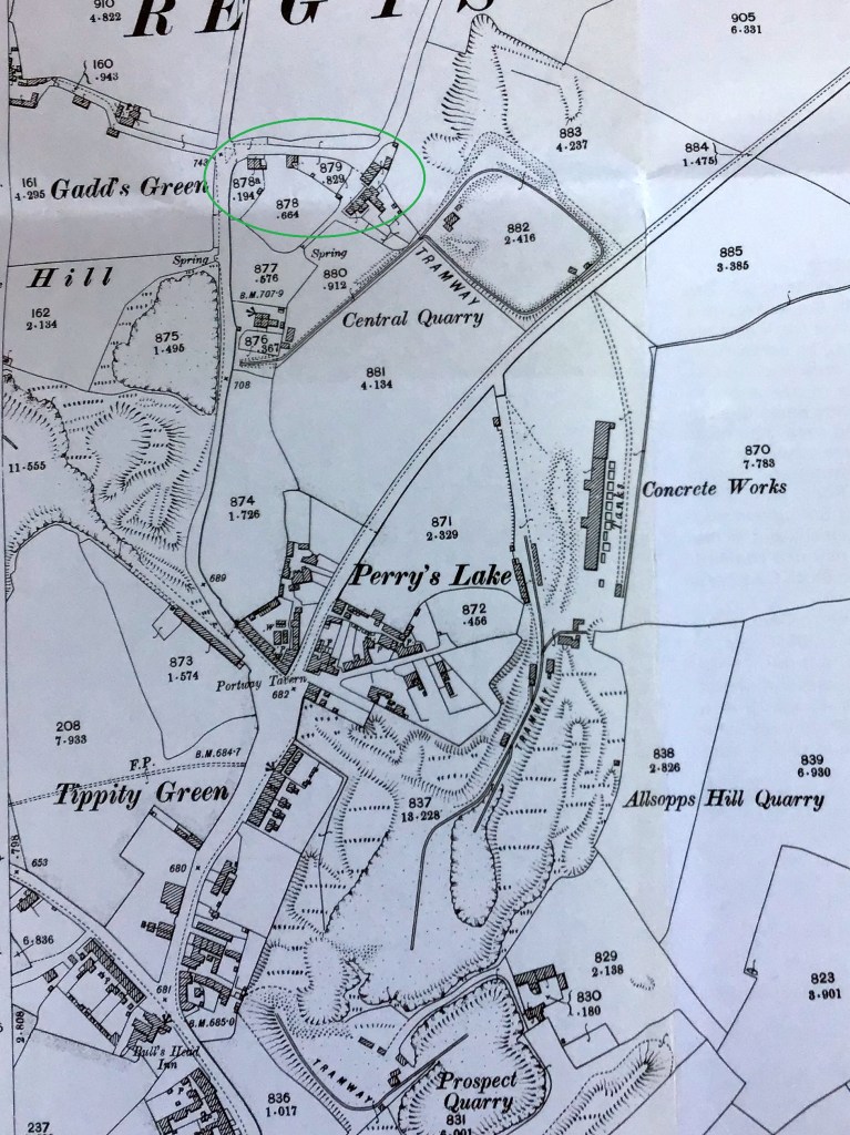
Copyright and date unknown but I think this map is part of a copy of the map drawn up before 1800 for the Rowley Regis Enclosures. You can see that John Alsop was renting quite a bit of land here which subsequently became Alsop’s quarry. And in the middle at the bottom is a small oblong which has the name J Alsop , the word Mill and a little diagram of a windmill above the word Mill, although almost obscured by the plot number. So this shows where the Alsops were living, milling and farming. The Mill appeared to have an access road, too which has subsequently disappeared, unless, of course, it later became the site of the Club Buildings? The Alsops had arrived in the parish by 1734, possibly as Millers as there are various Alsops in nearby areas who were also millers.
But, as so often happens, when I got started on the Alsops, they turned out to be quite interesting and worthy of a post of their own to my blog (to follow soon!). And as I started to gather information on the children of Edward Alsop, who was the farmer there in 1841, I found that his second son Joseph had married a Sarah Eliza Dingley and was living in 1841 at the bottom of Rowley Village where he was a shopkeeper.
Straightforward enough so far, and I was interested to see the Dingley name, as I was at school with a Geraldine Dingley, back in the 1960s and I hadn’t come across it in other researches. Because Sarah Eliza had given her full name in the Census, I was able to find her marriage easily on FreeREG, she had married Joseph Alsop at Clent in 1832. And, as I could calculate her birth year from later censuses, I found her baptism on 25th December 1812 at Halesowen. She was the daughter of Ira Dingley (1789-1864) and Elizabeth nee Cooper (1788 -?), the eldest but one, I found, of about ten of their children baptised at Halesowen church. That sounded good, Ira is a relatively unusual name so should be easy to trace. As indeed he was. We will ignore for now that there were at least three more Ira Dingleys to follow in short order, son and grandsons which did complicate sorting them out later. But never mind…
This family all baptised their children at Halesowen, this was before Blackheath St Paul’s was built but they lived in the Hill area of Blackheath, Long Lane, Cocksheds, Gorsty Hill, Malt Mill Lane.
There are clues in these names, I think – Gorsty Hill was probably rough heathland with lots of prickly gorse bushes, the Long Lane really was a long lane leading from Rowley all the way to the King’s Highway at Quinton, there must have been some poultry business at Cocksheds and a brewer’s Malt Mill somewhere in the area – most pubs brewed their own beer but they needed Malt and therefore maltsters.
I was able to find this later Ira’s children William (1810-1842), Sarah Eliza (1812-?), Elisabeth or Betsy (1815-?), Ira (1819-1855), Henry (1822-1885), Paarai (1823-1905), Neri or Nari (1829-?), Edmund (1829-?) and Edward (1830-?). Imagine what it would have been like in that household? Two people called Ira, one called Paarai and one called Nari? Did you shout for me? Recipe for confusion…
I was particularly interested in Nari or Neri, that really is an unusual name. But I do have two other Neris on my family tree – my great-grandfather and great-great-grandfathers were both Neri or Nari Ingley or Hingley – my aunt knew her grandfather and pronounced his name ‘nar-eye’ but he usually spelled it Neri.
How about that for a coincidence? Neri Hingley/Ingley and Neri Dingley, both living within a mile of each other? They must have known each other, surely?!
Neri Ingley /Hingley
So my 2xg-grandfather Neri Ingley (1824-1901) – the spelling varied between Ingley and Hingley for quite a long time about this period – was baptised in 1824 at St Giles, the son of John Ingley and Mary nee Hackett of Old Hill. This Neri married three times – to Mary Slim (1827-1861), with whom he had eight children, then to widow Ann Aldridge nee Whitehouse ((1823-1869) with whom he had my great-grandfather Neri (1862-1934) and finally to Maria Taylor (1832-1906) with whom he had two more sons. Busy lad.
Just to complicate my family tree, Neri Ingley was my 2xgreat-grandfather through Ann Whitehouse and their son Neri, but his third wife Maria Taylor was also my 2xgreat-grandmother through her first marriage to James Hewitt and their son Joseph. Although the 1861 Census just gives the abode of James and Maria Hewitt simply as Blackheath, they were living next door to William Taylor, who was Maria’s older brother and his wife Phoebe (and his step- daughter Sarah Whittall) and next to them was William Dingley, followed by the Hadley family so it seems very likely from this juxtaposition of families that they were living in this same area around the top of Gorsty Hill as in 1881. And the enumerator, in the description of his route, states that he was starting from the market place in Blackheath and covering both sides of the road towards Halesowen, to the top of Gorsty Hill which confirms this.
Lots more to untangle there – and another Hipkiss!
Neri Dingley
Neri Dingley was born a few years after Neri Ingley, he was baptised at Halesowen in February 1829, the son of Ira Dingley and Elizabeth nee Cooper. I have been unable to find any trace of him after his baptism, he is not listed with the rest of his family in the 1841 Census, he has disappeared. After a lot of checking and head scratching, I have come to the conclusion that Edward Dingley, apparently born about 1830 and Nari may be the same person. Edward appears in the 1841 Census, aged 10, as a son of Ira and Elizabeth but there is no baptism for him, I have checked all the way through the Halesowen Registers. Ira and Elizabeth Dingley had all of their other children baptised, why would they not have Edward baptised? And when Edward marries Matilda Johnson in 1856 he gives his father’s name as Ira Dingley. And he names his second son Nari. I can’t prove it but I suspect Ira became known as Edward.
Ancestry Hints
Perhaps this dearth of information about Nari/Neri Dingley accounts for some confusion. When I started to research this Neri on Ancestry, I was pleased to see that there were 14 hints for him, as although I always check sources for these hints, they can be useful shortcuts. This number of hints is often a sign of someone who has already been fully researched by others and it is possible to check their sources to satisfy yourself that you are researching the same person.
But when I looked at the hints, they all related to Neri Hingley, not Neri Dingley. I know because most of them referred back to my original research on Neri Hingley which had been faithfully copied by someone else! But it did throw me for a little while. They were definitely not the same person. Surely the two men had no actual family connections? I had not found any in my forty years of family history research.
The Dingley family in Long Lane/Cocksheds Lane
While I was doing the basic research on the family of Sarah Eliza Dingley, which was where I first came across the Dingleys, I found myself looking at her older brother, William Dingley, (1810-1842) and filling in his family. There were a number of Dingleys living in Cocksheds Lane, Gorsty Hill, Malt Mill Lane and Long Lane, over a number of decades, another family who tended to settle near each other. One census record in 1881 caught my eye.
Ira Dingley(1836-1894)
Amongst the children of William Dingley and his wife Rebecca nee Hadley, was another Ira Dingley , Sarah Eliza’s nephew who, in the 1881 Census, was living with his wife Phebe and their daughter Eliza in Malt Mill Lane. They had had seven children between 1854 and 1873, with most of the familiar Dingley names, including yet another Ira (1869). Checking for the marriage of Ira and Phebe, I discovered that they had married in 1858 in Halesowen church and that she was a Hipkiss, the daughter of Thomas Hipkiss, nailer. I just can’t get away from Hipkisses, it seems, they lie in wait for me and leap out when I’m not expecting them.
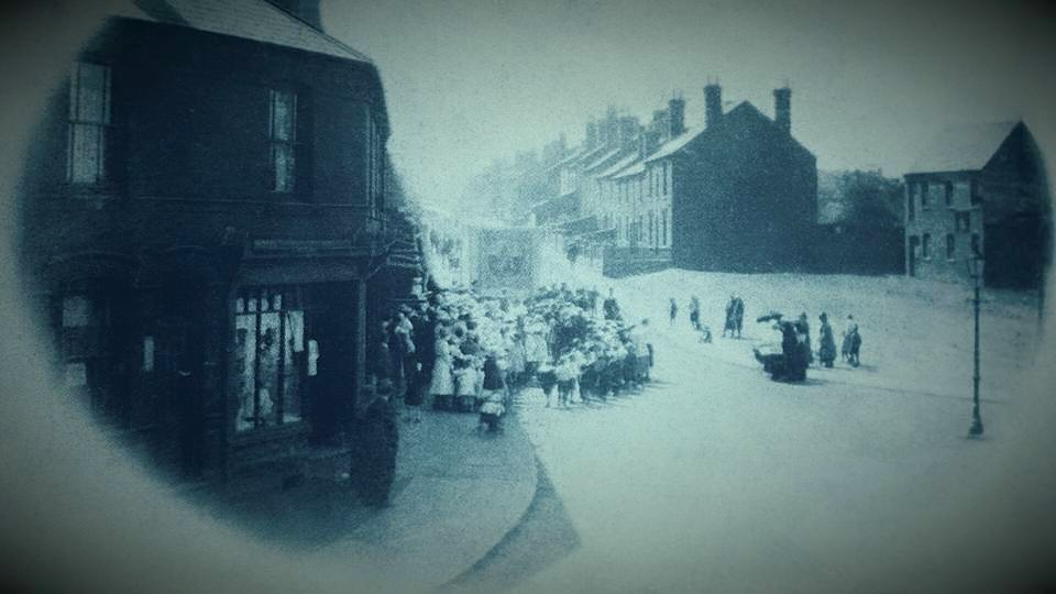
Copyright: Mark Bryan who posted this picture of Malt Mill lane on Facebook in 2015. He thinks it was taken about 1900 and it appears to feature a Chapel Witness Procession, possibly for Whit Sunday. (I wonder whether the little building on the far right was the Malt Mill?)
And the Whittall family
The Whittalls lie in wait, too, it seems. Because by the time of the 1881 Census, Ira and Phebe were living in Malt Mill Lane, next door to a Joseph Whittall, his wife Ann and their son James, Joseph born in Gorsty Hill, Ann in Old Hill and James in Blackheath. No direct connections obvious there, I thought, though worth some more checking.
Also living with Joseph and Ann was a Hannah Taylor who was shown as Joseph’s sister-in-law and her son Joseph Taylor who was 3 years old. Joseph’s place of birth was Cocksheds, so he hadn’t moved far. His mother Hannah gave her place of birth as Chalford, Gloucestershire. That stopped me in my tracks. I already had a Hannah on my tree who was born in Chalford, Gloucestershire – that seemed a strange coincidence – was this the same Hannah? It was indeed. The name had stuck with me because I live only a few miles from Chalford now and know it well.
The Aldridge family
Hannah Aldridge had married Benjamin Taylor in 1872 and she was my great-great-aunt, the daughter of Ann Aldridge (1823-1869) who had been born in Rowley Regis but married a canal boatman David Aldridge from Chalford , Gloucestershire in Dudley in 1846 and had borne him two children, George Aldridge (1848-1908) and Hannah (1850-?) in Chalford before he died in Dudley in 1855, whereupon she had obviously moved back to the Black Country with her two children. In 1841Ann had been living with her mother Hannah (nee Hodgetts) and step-father James Bird, her mother’s second husband, and she was living with James and Hannah again in Blackheath in 1861 (having been in Chalford with her husband in 1851). Ann’s maiden name was Whitehouse, the daughter of Joseph Whitehouse (1799-1828).
So, if Hannah was the sister-in-law of Joseph Whittall, how exactly was she related to him? Well, Joseph Whittall was the step-father of Benjamin Taylor, Hannah’s husband. Joseph’s wife Ann Whittall in this census had previously been married to Samuel Taylor who had died in 1852. What was this Ann’s maiden name, I wondered? I checked my family tree again. She was AnnIngley – daughter of John Ingley and Mary nee Hackett. So … Ira Dingley was living next door to Ann nee Ingley who was the sister of Neri Hingley.
But that was not the only link in this complicated family. Ann Whitehouse, mother of Hannah, had married again, after the death of her boatman husband. In April 1862 Ann Alldridge had married – taraaah! – none other than my great-great-grandfather Neri Hingley. So HannahTaylor, nee Aldridge was Neri’s step-daughter. Hannah was living with her step-aunt in 1881. I’m not sure how that made Hannah Taylor Joseph Whittall’s sister-in-law as I reckon she was his step-niece in law but she was certainly family of some sort! And Ann Whitehouse/Aldridge/Hingley’s son Neri Hingley (1862-1934) had married Phoebe Hodgetts (1865-1922) and had five daughters including my grandmother Beatrice Hingley.
There are two pages of the 1881 Census for Malt Mill Lane which read like a list from my family tree, this seems to have been another area where, once carefully examined, everyone was related to everyone else. Margaret Thompson, your great-grandparents George Eades and Elizabeth nee Harris were on the previous page, so no doubt these families would have been well known to them.
So, I finally arrived at the conclusion that (a) my attempt to move away, for a while, from researching Hipkisses and Whittalls had not really succeeded (and may never quite succeed) and (b) Neri Dingley and Neri Hingley may not have been related by blood but their families were certainly living very close if not next door to each other in the Gorsty Hill/Cocksheds area over a period of several decades and must have been closely socially intertwined. Neri Dingley may even have been named after Neri Ingley/Hingley, as he was born a few years after him.
I think I’ve worked it all out, made all the links, for now. But I have barely started on the other Dingleys so there may be more links to come!
In all, Timothy Hill (1763-1831) and Maria Hill nee Hipkiss (1782-1855) had seven children between 1800 and 1823, including Benjamin who may or may not have been the son of Timothy’s first wife Ann Priest or of Maria, his second wife. I have been aware of the number of children they had almost since I started my family history research but until now I had not realised how closely they all remained in their community.
Perhaps unusually for that period, it seems that all seven survived into adulthood and childbearing age. Although it is possible that there were other children that I have not found who lived only short periods or were stillborn.
Timothy was about 68 when he died. Two of the Hill sons died relatively young – Benjamin aged 44 in a colliery explosion and Joseph aged 49. Joseph was also a miner but the burial record contains no clues about his death. Samuel lived the longest of all the children, to the ripe old age of 90, very unusual for those days.
And the four girls also all lived long lives, most of them staying within the close neighbourhood of the Lost Hamlets. Maria, their mother, had lived to be 73. Mary Hill was 81, Ann and her sister Elizabeth (Betsey) were both 86 and Jane was 77 when they died. These were unusually long lives for those times, these girls must have inherited some strong genes!
Perhaps living up on the hill above the main settlements meant that they had space to grow some of their food, fresh air, free mostly of much pollution and similarly their water supplies from local springs were probably purer than water in wells lower in the valleys. Whereas many of the men were in quite hazardous occupations, their lungs subjected to constant exposure to coal dust, furnace fumes and quarry dust, with no safety equipment which may have impacted their health, not to mention the hazards of explosions in mines and quarries. But the women and children nail makers would also have worked in the dusty polluted air inside poorly ventilated nailshops.
Grandchildren
So how many grandchildren and great-grandchildren did Timothy and Maria leave?
Child No of children No. of grandchildren
Benjamin 4 27
Mary 9 53
Ann 6 28
Elizabeth 8 64
Jane 10 68
Joseph 5 27
Samuel 4 3
Total: 46 270
So, from their seven children, Timothy and Maria had about 46 grandchildren and the extraordinary total of about 270 great-grandchildren, 213 of these through their daughters so not bearing the Hill surname. Many of these stayed in the immediate area of the Lost Hamlets. So, I think it is fair to say that the Lost Hamlets were well populated with this family and their close connections.
I say about 46 and 270 grandchildren and because there are a couple of instances of people marrying their cousins so Timothy and Maria would be their grandparents twice over and there are also some children whose exact parentage is unclear. There may also have been some children who died in infancy who I have no information about. And a few people simply could not be traced after a certain point and they may have had more children wherever they were.
The Hill children married mostly local people, usually very local. Surnames of spouses in that generation include Whittall, Priest, Moreton, Taylor/Bridgwater, Hackett, Williams, Jones, Bate and Smith.
In the 1841 Census there are twelve households listed under Gadd’s Green or Finger-i-the-Hole, as it was known then, but I can only see one family listed there which is not named either Hill or one of the first four of these names – he was William Woodall. And even then, I suspect I will tie him into the Hill family at some point as he has a Pheby Hipkiss living in his household. So it appears to me that this hamlet was essentially a Hill family enclave. There were certainly Hills in Rowley as early as 1604, as mentioned in the Parish Register and it is likely that they were in the Lost Hamlets area then.
Timothy and Maria’s grandchildren married spouses called Tibbetts, Pearson, Worton, Pritchard, Steadman, Lowe, Whitmore, Blakeway, Jarvis, Parish, Cole, Hemmings, Bowater, Ingram, Leech, Homer, Slater, Priest, Redfern, Siviter, Beet, Parsons, Stokes, Nock, While, Payne, Westwood, Cox, Perry, Raybould, Pockett, Allen, Barnsley, Groves, Ennis, Fellows, Hadley, almost all of these familiar Rowley names.
The next generation linked with Bastable, Gazey, Horton, Harvey – and I have barely looked at that generation, there will be more names.
And yet there are other Rowley names which do not appear – no Parkes, Darbys, Rustons, Levetts, who were all farmers or business people. It appears generally that the Hill family married into families like themselves, nailers, labourers, miners, foundrymen, quarrymen – not many rags to riches stories but plenty of hard working people.
Family life for this part of the Hill tribe essentially centred – literally for centuries – around Gadd’s Green, on the Hill above Perrys Lake and Tippety Green which also provided homes for many of the overspill, which then edged along into Hawes Lane and Siviters Lane.
As I related in a previous post (Tales of Old Portway – https://rowleyregislosthamlets.uk/2023/10/15/tales-of-old-portway/) in a newspaper report about Portway, the reporter noted that “The cottage is said to be over 300 years old and one family – that of Hill, members of which reside in an adjacent cottage – lived there for nearly 200 years.” That 300 year old cottage was built then in about 1600, which ties in neatly with the first mention of John Hill in 1604.
Copyright: Alan Godfrey Maps:
This map shows Gadds Green in 1902 and there are only perhaps twelve cottages shown, none of them of any great size but as I set out in a previous post, (A Hall House at Gadd’s Green?) I think that the group of buildings shown on the right of the green circle on this map was where the Hill’s, in all their nomenclatures, lived and that it is likely that their house started as a hall house and was later sub-divided.
And when these descendants moved away they often stayed in close proximity to other members of the family, little colonies of Hills. And there were other Hill families in the area, these articles relate only to Timothy and Maria’s descendants.
Overcrowding
And the crowded conditions in which many of them lived and on which I have commented several times in these posts, were recognised by officialdom. In his 1875 report on living and sanitary conditions in Rowley Regis, Dr Edward Ballard (who prepared similar reports for many surrounding areas for the government) noted specifically:-
“Overcrowding of cottages, although, of course, not universal, nor perhaps very general, must, from my observation in this matter, be pretty common in many parts. Some of the worst cases I chanced to fall upon during my inspection were at a group of cottages at Gadd’s Green; in Mrs Siviter’s cottage at Hawes Lane, Rowley, and in one of the old cottages opposite the gas-works at Old Hill. In some of the instances of overcrowding which came under my observation, lodgers were taken in; in others the occupants belonged to the same family, but were grown-up sons and daughters of the tenant of the cottage with (in the worst case of all) a number of illegitimate children of two of the girls.”
I remember reading that paragraph for the first time, sitting in The National Archives in October 2023 and mentally noting the specific reference to Gadd’s Green. But it was only re-reading this section of the report last week that the penny dropped and, having done those detailed reports on each of the Hill children, I knew exactly which family Dr Ballard was referring to!
Improvements to Housing
The general overcrowding in the parish and the poor conditions of many cottages was to lead in the 20th century to a huge programme of house building which led to the local council setting out big new estates around Britannia Road, below Britannia Park and below Rowley village in the Throne estates. Houses in poor condition were regularly inspected, condemned and either improved or demolished and the tenants were offered new houses.
The detailed inspections which were undertaken, to meet the obligations increasingly imposed on local councils by various housing legislation, can be seen free online in the Annual Health Reports which were made by the Medical Officer and Sanitary Inspectors to the Rowley Regis Council. Some of these are available at The National Archives and others can be downloaded from the Wellcome Foundation. If you search online for Wellcome Foundation and then search their site for Rowley Regis Health reports there are three pages listing reports, and you can download any of them to read later. They date from the early 1890s to the 1960s and make very interesting reading, dealing with all aspects of health, births and deaths, housing, sanitation, water supply and refuse disposal, many reports listing all the staff by name. And there were remarkably few staff with a lot of duties, especially in the earlier years! I have not found the reports for every year but enough to be able to observe the changes that came over the area.
What a contrast it must have been to move from a poorly maintained damp possibly subsiding two up two down cottage with no damp courses, earthern floors, poor water supply and little or no sanitation, into a newly built house with generously sized accommodation and front and large back gardens, a three or four bedroom house with a separate kitchen and bathroom, all on spaciously laid out and designed estates, not just long straight rows of cottages as had sprung up in Blackheath in the mid-late 1800s, all within easy walking access of Blackheath town, shops, churches and chapels, schools and all the facilities they needed. And very often with familiar faces living nearby as the worst areas were cleared.
Conclusion – Kith and Kin in the Lost Hamlets
I hope that my readers have found this long and detailed account of one family in the Lost Hamlets interesting and that it may have been helpful to anyone with Hill ancestors. I am seriously considering combining all these articles into an e-book to keep all the information together.
It seems likely to me that, for centuries, these small communities in these hamlets were very insular and did not really regard themselves as part even of Rowley village proper, until the growth of Blackheath, better housing and opportunities in industry enticed later generations away from the hill.
This family study has, for me, illustrated very clearly the intrinsic web of kith andkinship which existed in the area of the Lost Hamlets and the extent to which people in the Hamlets married the boy or girl next door. (Originally, “kith” meant one’s native land or country, then broadened to include friends and neighbours, kin meant immediate and wider family.)
I follow the blog of another One Placer who is working on a OPS of a village where his ancestors lived. Over the past couple of posts he has been describing how he now has one large tree which covers most of the people which he refers to as a ‘forest’, rather than a tree. I think there is something in that analogy but in my case I do not think the Lost Hamlets or even the Hill family amount to a forest. So I looked up other words for a group of trees and I decided that the word to describe the kinship in the Lost Hamlets is a ‘spinney’ which is apparently defined as “A thicket or small wood, often on higher ground”, a thicket by the way is “a dense, tangled mass of shrubs and small trees” which seems very appropriate. So my Lost Hamlets families are all part of the Lost Hamlets Spinney!
A ‘spinney’ on a hill! Copyright Mark Schofield and Glenys Sykes
It is now apparent that as I research for more family studies in this area that I will keep finding they were also kith andkin and will link back to this research and the work I have done on other families, more trees and shrubs within the Spinney! And I observe that such webs of kinship were the norm in many small places and in small places within larger places. Tribes might be another description, although that can have sinister connotations these days. But tribes looked after their own and protected them. This, albeit a long time later, is my tribe.
How astonished these people would be, I suspect, to stand in Tippity Green today and see that almost all of the places in which they, their ancestors and many of their descendants lived their lives have completely disappeared. More astonished still, perhaps, to know how much information about them we are able to put together two hundred years later, how could they have imagined such interest in them and their lives?
But these small hamlets and the people who lived in them will not be forgotten, at least by me!
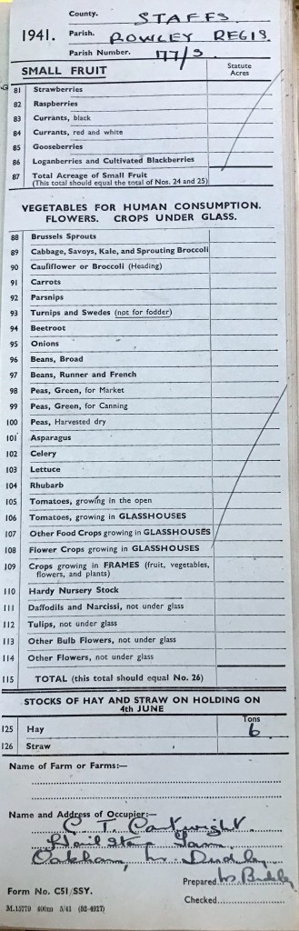
In 1941 and over the next two years detailed surveys were carried out by the Government to assess the quantity and quality of farmland available to feed the nation during the War. The original forms , known as MAF (Ministry of Agriculture and Food) 32, can be seen at The National Archives so on a recent visit I arranged to see the file for farms in Rowley Regis and photographed many of them, from which I have extracted the information which follows. With full copyright acknowledgment to The National Archives, I have used different sections of the form relating to one farm – Hailstone Farm – in this article but the same farms were available for each farm and I have extracted details below.
First Section: The first set of forms No.C51/SSY in 1941 listed various crops and how much land was in use for each sort of crop being grown. Under Small Fruit were listed Strawberries, Raspberries,Currants – black, Currants red and wite, Gooseberries, Loganberries and Cultivated Blackberries, with a sub-total for the Total Acreage of Small Fruit.
The next section was for Vegetables for Human Consumption. Flowers. And Crops under Glass. Here the crops listed were Brussels Sprouts, Cabbage (Savoys, Kale and Sprouting Broccoi), Cauliflower or Broccoli (Heading), Carrots, Parsnips, Turnips and Swedes (not for fodder), Beetroot, Onions, Beans – Broad, Beans – runner and French, Peas – green for market, Peas – green for canning, Pease – harvested dry, Asparagus, Celert, Lettuce, Rhubarb, Tomatoes – growing in the open, Tomatoes – growing in Glasshouses, Other Food Cops growing in Glasshouses, Crops growing frames – fruit, vegetables, flowers and plants, Hardy Nursery Stock, Daffodils and Narcissi – not under glass, Tulips –not under glass, Other bulb flowers – not under glass, other flowers – not under glass, with again, an acreage total for each category and a subtotal.
The third section was for Stocks of Hay and Straw on the holding.
This is the completed form for Hailstone Farm.
Copyright The National Archives Document MAF 32/604/177, Extract.
So this was a comprehensive assessment of what was being grown that summer on the farms and small holdings of the country. A remarkable number of these for Rowley were Nil returns – nothing being grown, I was beginning to think that the Rowley farms were remarkably unproductive.
What happened next?
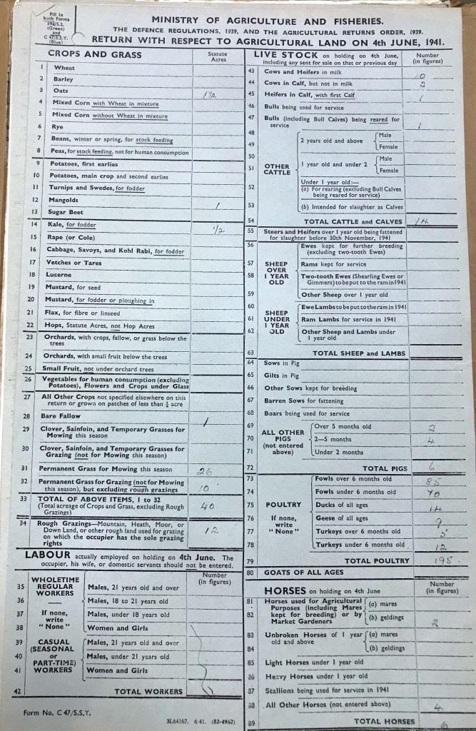
I have to confess that I cannot quite work out how the forms fitted togeether and whether they all went out at one time. But the information is pretty clear. Much more detailed surveys were compiled on Form No. C.47/S S Y which went into the size, condition, usage of the farm, the number of men employed, details of Live Stock broken down into very specific detail.
The first section listed the Statute Acres for growing each of these crops on 4th June – Wheat, Barley, Oats, Mixed corn with wheat in mixture, Mixed corn without wheat in mixture, Rye, Beans – winter or spring, for stock feeding, Peas for stock feeding, not for human consumption. Then the acreage used for vegetables had to be listed – Potatoes – first early, Potatoes – main crop and second earlies, Turnips and Swedes for fodder, Mangolds and Sugar Beet. Kale – for fodder, Rape (or Cole), Cabbage, Savoys and Kohl Rabi for fodder, Vetches or Tares, Lucerne, Mustard – for seed, Mustard for fodder, Flax – for fibre or linseed, Hops – Statute Acres – not Hop Acres, the form says sternly – who knew there was a difference?
Then acreage of Orchards had to be shown – those with crops, fallow or grass below the trees and those with small fruit below the trees had to be shown separately, and Small Fruit not under orchard trees.
Vegetables for human consumption (excluding potatoes) had a line to themselves but included Flowers and Crops under Glass. All other crops followed, including clover, Sainfoin, grass for mowing and got grazing. Then the form details information about the labour employed on the farm (not including the occupier, his wife or domestic servants). Followed by full details of the stock held, right down to the last piglet and hen, with horses required to be listed by their use and their age.
A copy of the form for Hailstone Farm is shown here, it makes interesting reading.
copyright The National Archives Document MAF 32/604/177, Extract.
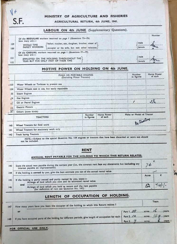
The next section of the form required details to be given of the Labour employed on the 4th June 1941, including the family of the occupier and whether regular or casual, whole or part time. Then a section on Motive Power on each holding had to be completed, water wheels or turbines – in use or not, whether repairable if not in use, Steam engines, Gas Engines, Oil or Petrol Engines, Electric Motors or others – state kinds, the form says. It’s difficult to think of any other kinds, but there was obviously no excuse for not declaring it if there were any! Edit: A later part entry for one farm lists a horse – which was of course for many the main source of motive power for centuries, those or oxen. Then there was a section requiring information on Tractors held, of various sorts, with information required on the make and model.
Next the form required details of the rent being paid for the holding – if the land was owned by the occupier, the owner was required to give their best estimate of how much the rental value was. And how long the holding had been occupied by the current occupier.
copyright The National Archives Document MAF 32/604/177. Extract
Later Survey
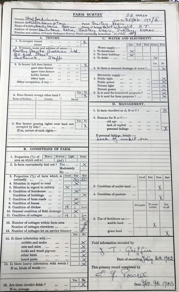
A later Survey gave a detailed picture, not only of the amount of land held but how it related to such things as access to transport, condition of buildings, facilities and an assessment of whether the farm was being farmed efficiently. Again, this is the form relating to Hailstone Farm, part of the same form as previously.
Copyright The National Archives Document MAF 32/604/177. Extract
There were a few copies of each of these forms relating to farms in Rowley. I have grouped the details under each farm and although they are, to some extent, repetitive, I hope they will be of interest.
Hailstone Farm
The name of the Occupier at Hailstone Farm was C or G Cartwright. What was he growing in that first survey? Ah, sadly, none of the crops listed, except that he had 6 tons of hay – just one entry!
At Hailstone Farm on the longer form, there were no additional labourers so all the work must have been done by the occupier Mr Cartwright and his family. He had one 3½ horsepower Oil or Petrol engine and no tractors at all. His rent was £74 per annum. Under the length of tenancy, he stated that he had rented 35 acres for 16 years, 10 acres for 9 years and a further 7 acres for 6 years.
Farm Survey: The survey was carried out on 16 July 1942. The owner of Hailstone Farm, with 52 acres was Rowley Granite Quarries Ltd., which was based in Smethwick High Street. Mr Cartwright was a full time farmer, but occupied no other land and had no grazing rights elsewhere. T he farm was said to be conveniently laid out.
All of the land was classified as medium weight., as opposed to Heavy, Light or Peaty. The condition of the farm was judged to be naturally 50% Fair and 50% Bad, with fair access to roads, good access to railways. The condition of the farmhouse was fair but that of the farm buildings was bad. Farm roads and fences were in fair condition as was the general condition of the field drainage but there were no ditches nor cottages. No problems were noted with infestations of rabbits, rats or rooks, etc nor any heavy infestation with weeds nor derelict fields. Water supply to the farmhouse and buildings was by pipe and to the fields by stream. There was no electrical power supply at all. The condition of the arable land and pasture was judged to be poor and, although fertilisers were used to some extent on arable land, they were not used at all on grassland. The overall verdict on management of the farm? It was graded B (out of a possible A, B or C, it appears). Of the possible reasons for this, it was noted that this was due to personal failings – a lack of ambition! They certainly weren’t pulling any punches, were they?
Turner’s Hill Farm
T E Monk at Turner’s Hill Farm was another nil return on the first form. The later form showed that he had no additional workers and no machinery. He was paying £67 per annum for 27 acres and had rented it for 13 years in 1941.
Farm Survey: Carried out on 31 Aug 1943. Turner’s Hill Farm was also owned by Himley Estates. Mr Monk was described as a ‘spare time’ farmer who was also a Factory Employee., with no other land or grazing rights. The farm was said to be conveniently laid out. The farm conditions showed that the soil was 50% Medium and 50% Light and the proportions of the farm was judged to be naturally 40% Fair and 60% Bad, with good access to roads, and fair access to railways. The condition of the farmhouse and buildings was fair. The farm roads were good and fences were in fair condition as was the general condition of the field drainage although the ditches were noted as Bad. There was one cottage within the farm area. No problems were noted with infestations of rabbits, rats or rooks, etc nor any heavy infestation with weeds, there were no derelict fields. Water supply to the farmhouse and to the farm buildings and fields was by pipe. There was no electrical power supply at all. There was no seasonal shortage of water noted. The condition of the pasture land was good and fertilisers were used adequately on grassland. The overall verdict on management of the farm? It was graded B (out of a possible A, B or C, the reason given for the downgrading was ‘Divided Interests’, presumably relating to Mr Monk’s other employment.
Old Portway Farm
The first form for Old Portway Farm, occupied by Phoebe Cooks, showed just 2 tons of hay.
But the more detailed form showed that Mrs Cooks was growing a total of three acres of Main Crop potatoes, turnips/swedes and mangolds. She had 8½ acres of mowing grass and 15 acres of grazing grass plus 2½ acres of rough grazing – there seems to have been a lot of this in Rowley, perhaps due partly to the effects of quarrying and mining settlement. She had three workers, one male and one female whole time workers and one part-time male. These cared for her 6 cows in milk, her 6 cows in calf but not in milk and 1 bull (used for service). There was one other female cattle aged between one and two years, giving a total of 14 cattle. There were no sheep or pigs but she had 85 fowls over 6 months old, 68 under 6 months and 3 ducks! The remaining live stock consisted of three geldings and one other horse.
On the next page, Mrs Cooks stated that she had one wholetime family worker (male, so not herself) and one part-time casual male worker. She also, like Mr Cartwright at Hailstone Farm, had one 4hp horsepower Oil or Petrol engine and no tractors at all. Her rent was £56/10shillings per annum for 29 acres. Under the length of tenancy, she stated that she had rented the land for 30 years.
Farm Survey: Carried out on 22 May 1942. The owner of Old Portway Farm, with 26½ acres, we can now see, was again Rowley Granite Quarries Ltd., which was based in Smethwick High Street. Mrs Cooks was a full time farmer, but occupied no other land and had no grazing rights elsewhere. The farm was said to be conveniently laid out.
All of the land was classified as medium weight, as opposed to Heavy, Light or Peaty. The condition of the farm was judged to be naturally 100% Fair, with fair access to roads, and good access to railways. The condition of the farmhouse and buildings was fair. There were no farm roads and fences were in fair condition as was the general condition of the field drainage and ditches. There were no cottages. No problems were noted with infestations of rabbits, rats or rooks, etc nor any heavy infestation with weeds, there were 2.5 acres of derelict fields. Water supply to the farmhouse was by pipe and to the farm buildings fields by well. There was no seasonal shortage of water noted. There was no electrical power supply at all. The condition of the arable land was judged to be fair and of the pasture good and, although fertilisers were used adequately on arable land, they were only used to some extent on grassland. The overall verdict on management of the farm? It was graded A (out of a possible A, B or C, it appears).
Lower Portway Farm
Joseph Cooks, at No. 17 – Lower Portway Farm had even less hay – he had nothing entered on his farm on the first form but more detail on the second. He had two acres growing the same crops as Mrs Cooks, plus 5 acres of mowing grass and 10½ acres of grazing grass. He had 3 cows in milk and two in calf with their first calf plus a bull under 1 year old which was being reared for service. No sheep or pigs but 120 fowls over 6 months, 50 fowls under six months and three ducks. He had no horses!
Farm Survey: Carried out on 14 May 1942. The owner of Lower Portway Farm, with 17¼ acres, was Himley Estates Ltd, with an office address in Dudley. Mrs Cooks was a full time farmer, but occupied no other land and had no grazing rights elsewhere. The farm was said to be conveniently laid out.
All of the land was classified as light weight, as opposed to Heavy, Medium or Peaty. The condition of the farm was judged to be naturally 100% Fair, with good access to roads, and fair access to railways. The condition of the farmhouse, farm buildings and farm roads was fair. The fences and ditches were in fair condition and the general condition of the field drainage and ditches was good. There were no cottages. No problems were noted with infestations of rabbits, rats or rooks, etc nor any heavy infestation with weeds, there were no derelict fields. Water supply to the farmhouse and the farm buildings was by pipe and to fields by stream. There was no seasonal shortage of water noted. There was no electrical power supply at all. The condition of the arable and pasture land was good and fertilisers were used to some extent on both arable and grass land. The overall verdict on management of the farm? It was graded A (out of a possible A, B or C).
175 Dudley Road
The Danks brothers were listed on the first form at 175 Dudley road and they had just 1 ton of hay.
The later section shows that they were farming 15½ acres, of which they were the owners. The farmer was described as a part-time Dairyman, with no other land or grazing rights. All of the land was classified as light weight and the farm was said to be conveniently laid out.
Farm Survey: Carried out on 20 Sep 1943. The condition of the farm was judged to be naturally 40% Fair and 60% Bad, with good access to roads and to railways. The condition of the farmhouse and farm buildings was fair. There were no farm roads. The fences and ditches were in fair condition and the general condition of the field drainage and ditches was fair. There were no cottages. No problems were noted with infestations of rabbits, rats or rooks, etc nor any heavy infestation with weeds, there were no derelict fields. Water supply to the farmhouse, the farm buildings and to fields was by pipe. There was no seasonal shortage of water noted. There was electrical power from the public company for light and power, which was used for household but not farm purposes. The condition of the pasture land was good (no arable land)and there was adequate use of fertilisers on the grass land. The overall verdict on management of the farm? It was graded A (out of a possible A, B or C).
‘The Stores’, High Street, Rowley Regis
Samuel Goode was listed at ‘The Stores’, High Street, Rowley Regis and he, too had a zero return on the first form. On the later form he had no crops, no workers and no animals – or at least none of his own, he had a note saying that he had no fowl of his own but let a corner piece of land to someone called Jackson who had about 50 fowl there.
He had no additional labour, no machinery and held 7 acres at a rent of £3/10shillings which he had rented for 7 years, noted in pencil at the bottom of the form as for rough grazing only. I wonder where his land was?
Farm Survey: Carried out on 2 Sep 1943. As might be expected he had a nil return to almost all of the questions on the last section, though his land was classed as 100%light and was not stated to be derelict but the proportion of the farm which was naturally bad was 100%. There were no buildings and the water supply to his field was noted to be by ‘pit’. No power! Fertiliser was used to some extent on what was classed as grass land but the holding still managed to be classed as A, somehow.
Brickhouse Farm
The first return for the Brickhouse Farm was completed by the Borough Surveyor at the Old Hill Offices of the RRUDC and he listed a half acre of onions being grown and half a ton each of Hay and Straw. The later form reported that there were 6 ¼ acres growing oats, 2 acres growing first early potatoes and 15 acres with main crop potatoes, 1 acre growing vegetables for human consumption, 1 acre bare fallow, and 45 acres of mowing grass, plus 17 acres of rough grazing. Contrary to what is stated elsewhere on these forms, he states that there are two full time male workers or 21 and one under 18, and four casual seasonal workers, giving a total of seven. Perhaps these were actually Council employees, rather than specifically employed by the farm. There were no animals on the farm other than one horse, a gelding. But a later part of the form shows that this was apparently the only local farm with a tractor so they did not need to keep many horses.
The next part of the return for Brickhouse Farm shows that it had no men working it and that 57 ½ acres had been rented since April 1939 for a mere £12. Presumably this land was what later became the Brickhouse housing estate. A second return by the same officer still employed no men but boasted a 25hp Fordson tractor. Here 49 acres was owned by the Council with an estimated rent value of £85pa, and a further 38¼ acres rented at £19/2/6. I suppose this could include the land on which the Grammar School was built in the early 1960s. Of this land, 67 acres had been held for only 2 years and 20¼ acres for 5 years. Perhaps the Rowley Regis Council was buying up land as it became available for future uses.
Farm Survey: Carried out on 11 Oct 1943. The owner of Brickhouse Farm, with 70 acres is shown to be Rowley Regis Boro’ Council. The full time farmer was noted as a Bailiff but he occupied no other land and had no grazing rights elsewhere. The farm was said to be conveniently laid out.
All of the land was classified as medium weight, as opposed to Heavy, Light or Peaty. The condition of the farm was judged to be naturally 50% fair and 50% bad, with good access to roads and railways. The condition of the farmhouse and the farm buildings was fair. The farm roads and fences were fair and the general condition of the field drainage and ditches was fair. There were no cottages. No problems were noted with infestations of rabbits, rats or rooks, etc nor any heavy infestation with weeds, there were no derelict fields. Water supply to the farmhouse and the farm buildings was by pipe and to fields by pit. There was no seasonal shortage of water noted. There was no electrical power supply. The condition of the arable land was judged to be fair and of the pasture poor and fertilisers were used adequately on arable land and grassland. The overall verdict on management of the farm? It was graded A.
Throne Farm
W Skidmore at Throne Road had 4 tons of hay on the first form. The next form shows that he had two additional full time workers but no motors of any sort or any tractor. His 33 acres was apparently valued at a rental of £40 and he had occupied it for 20 years.
Mr Skidmore was growing 1 acre of turnips and swedes for fodder and 2 of mangolds with 20 acres of mowing grass and 10 of grazing grass. He had two adult male workers who looked after 17 milking cows and 3 cows in calf. He also had a sow in pig and 5 piglets aged 2-5 months but no fowl of any sort. He had 2 mares and 5 other horses, 7 in total.
Farm Survey: Carried out on 16 Jul 1942. Mr Skidmore was the owner of the farm and that he was a full time farmer, he occupied no other land and had no grazing rights elsewhere. The farm was said to be conveniently laid out. The soil was deemed to be naturally 50% medium and 50% light. The proportion of the farm which was naturally good was 60%and 40% fair, with good access to roads and railways. The condition of the farmhouse was fair and the farm buildings good. The farm roads and fences were fair and the general condition of the field drainage and ditches was good. There were no cottages. No problems were noted with infestations of rabbits, rats or rooks, etc nor any heavy infestation with weeds, there were no derelict fields. Water supply to the farmhouse and the farm buildings was by pipe and to fields by stream. There was no seasonal shortage of water noted. There was electrical power supply used in the farmhouse and for farm purposes. The condition of the arable land was judged to be good and of the pasture fair and fertilisers were used adequately on the arable and grassland. The overall verdict on management of the farm? It was graded A.
Farm Survey: Carried out on 12 Sep 1944. Mr Skidmore also owned land at Whiteheath Farm, 31 acres of this. All of the land was classified as medium weight, as opposed to Heavy, Light or Peaty and the farm was said to be conveniently laid out. The condition of the farm was judged to be naturally 25% fair and 75% bad, with good access to roads and fair access to railways. There was no farmhouse, farm buildings or farm roads and fences were good and the condition of the ditches and the field drainage was fair. There were no cottages. No problems were noted with infestations of rabbits, rats or rooks, etc nor any heavy infestation with weeds, there were no derelict fields. Water supply to the fields was by stream. There was no seasonal shortage of water noted. There was no electrical power supply. There was no arable land and the pasture was rated fair and fertilisers were used adequately on the grassland. The overall verdict on management of the farm? It was graded A.
1 Oakham Farm
David Whitehouse at 1 Oakham Farm had nothing to list on the first form. But the next form shows that he was growing maincrop potatoes, turnips/swedes and mangolds, and there were 16 acres of mowing grass and 20 of grazing grass. Two whole time men over 21 were employed and one 18-21 year old. There were 8 cows in milk, no poultry but three mares, plus one unbroken gelding and one other horse.
The next section shows that he had just one full time male family worker – presumably himself and no engines, although he did add that he had one source of motive power – a horse! He owned 1 acre and had rented a further 44 acres for £54pa for 11 years.
This farm was owned by F W Gould who had an address in Tipton. The farmer was full time and had no access to other land or grazing rights. All of the land was classified as medium weight and the farm was said to be conveniently laid out.
Farm Survey: Carried out on 5 Aug 1942. The condition of the farm was judged to be naturally 65% good and 35% fair, with good access to roads and railways. The condition of the farmhouse the farm buildings was fair as was the condition of the farm roads, fences and the field drainage. There were no ditches or cottages. No problems were noted with infestations of rabbits, rats or rooks, etc nor any heavy infestation with weeds, there were no derelict fields. Water supply to the farmhouse was by pipe and to farm buildings and fields by pits. There was no seasonal shortage of water noted. There was no electrical power supply. The condition of the arable land and pasture land was rated fair and fertilisers were used adequately on the arable land but only to some extent on the grass land. The overall verdict on management of the farm was graded B, with a note that the reason for this was ‘personal failings – lack of Ambition’.
2 Oakham Farm
Bert Whitehouse at 2 Oakham Farm was another farmer with nothing to list on the first form. But the next form shows a name of Joseph Whitehouse – brothers to David, perhaps? – at 2 Oakham Farm which had 13 acres of rough grazing, and one adult man working. There were 10 cows in milk and 50 fowl, plus 21 ducks, with one horse which did not fall into any of the agricultural designations, perhaps a riding horse.
This farm also had one additional full time worker – a daughter. There were no motors or tractors either and the ten acres of land had been rented for 35 years, the rent was £28pa.
Farm Survey: Carried out on 11 Aug 1942. Mr Whitehouse was noted as the owner of the farm and was a full time farmer, though with no access to other land or grazing rights. All of the land was classified as medium weight, as opposed to Heavy, Light or Peaty and the farm was said to be conveniently laid out. The condition of the farm was judged to be naturally 100% fair, with good access to roads and fair access to railways. The condition of the farmhouse and the farm buildings was fair. There were no farm roads and fences were bad and the general condition of the field drainage and ditches was fair. There were no cottages. No problems were noted with infestations of rabbits, rats or rooks, etc nor any heavy infestation with weeds, there were no derelict fields. Water supply to the farmhouse and the farm buildings was by pipe and to fields by pits. There was no seasonal shortage of water noted. There was no electrical power supply. There was no arable land and the pasture was rated fair and fertilisers were used adequately on the grassland. The overall verdict on management of the farm? It was graded B with a note that the holding was farmed by an old widow who ‘lacked management’. This is slightly contradictory because elsewhere on the forms the farmer is described as Bert Whitehouse but perhaps the farm was owned by his mother.
Lamb Cottage, Throne Road, Whiteheath
J Matthews at Lamb Cottage, Throne Road, Whiteheath had nothing to list on the first form. The second form shows that he had no crops but 4 acres of grazing grass and 2 acres of rough grazing. His livestock comprised one sow kept for breeding, 3 piglets aged 2-5 months and 10 under 2 months. There were 25 Fowls over 6 months, 4 ducks, 6 geese, 2 turkeys over 6 months and 8 under 6 months. But no horses.
Details on the next page show that he had rented just 6 acres for one year at £6. And had neither additional workers nor motive power. Of this land, a pencil note adds that 2 acres was rough grazing.
Farm Survey: Carried out on 2 Sep 1943. This farm was owned by Mr Cartwright of Hailstone Farm. The farmer Mr J Matthews was described as a part-time farmer and his other occupation was given as Farm Worker. He had no access to other land or grazing rights.
All of the land was classified as medium weight, and the farm was said to be moderately conveniently laid out. The condition of the farm was judged to be naturally 100% fair, with good access to roads and railways. The condition of the farmhouse and that of the farm buildings was fair. The condition of the farm roads, fences and ditches was fair as was the general condition of the field drainage. There were no cottages. No problems were noted with infestations of rabbits, rats or rooks, etc nor any heavy infestation with weeds, there were no derelict fields. Water supply to the farmhouse and the farm buildings was by pipe and to fields by stream. There was no seasonal shortage of water noted. There was apparently an electrical power supply to the house but not the rest of the farm. The condition of the pasture land was rated fair (no arable land)and fertilisers were used adequately on the grassland. The overall verdict on management of the farm was graded A.
Warrens Hall Farm
At Warrens Hall Farm, the Wooldridge Brothers had nothing to enter on the first form. They were growing 7 acres of oats, 2 of mangolds and 1½ acres of kale for fodder on the next. There was 30 acres of mowing grass and 45 of grazing grass, plus 16½ acres of rough grazing and 69 acres of golf course! For this they had one whole time and one part time seasonal worker – there were 20 cows in milk, and 12 in calf but not in milk. Under Poultry, there were 60 fowls over 6 months old and 40 under, 5 ducks and 4 turkeys over 6 months old, the first turkeys I have seen mentioned in these returns. The horses included 3 geldings and 2 other horses.
The next part of the form shows that there was one whole-time male family worker, plus one male and two female part time workers, with – again – no motive power of any sort. The annual rent for the 171 acres was £110 and it had been rented since 1913, 28 years.
Farm Survey: Carried out on 11 May 1942. Warren’s Hall Farm was owned by the Himley Estates Ltd with an office in Dudley. The farmer was recorded as full time and the farm included access to 69 acres held by Dudley Golf Club. But the farmer had no other grazing rights.
All of the land was classified as medium weight, and the farm was said to be moderately conveniently laid out. The condition of the farm was judged to be naturally 10% good and 90% fair, with fair access to roads and railways. The condition of the farmhouse was good and that of the farm buildings was fair. The condition of the farm roads, fences and ditches was fair as was the general condition of the field drainage. There were no cottages. No problems were noted with infestations of rabbits, rats or rooks, etc nor any heavy infestation with weeds, there were no derelict fields. Water supply to the farmhouse and the farm buildings was by pipe and to fields by stream. There was no seasonal shortage of water noted. There was apparently an electrical power supply to the house and farm. The condition of the arable land was good and the pasture was rated fair and fertilisers were used adequately on them both. The overall verdict on management of the farm? It was graded A.
Who completed the forms?
All of these forms were prepared by independent officials, one recording field information and visits taking place over a period of two years in all and the primary record being completed by another official at a later point. The visiting officials were J Griffin who seems to have visited some sites in July, August , September and October 1942, August, September and October 1943, and September 1944. C A Dickinson visited a couple of farms in May 1942.
The signing off of the primary record seems to have been the responsibility of E M Powell or E M Casstles and happened sometimes months or even more than a year later. The writing of the E M in the signatures is identical so I suspect that it was the same person who was a woman who got married!
Summary
These forms related to the farms which I could identify in the file as in and around the area of the Lost Hamlets. There were a few more forms with vague descriptions of the land they referred to – (land off …Road, etc) – often small areas and usually owned by companies or contractors and not with local family names that I recognised and I have not included these in this piece. Nevertheless I hope that I have covered most of the farms and smallholdings known to local people.
The information gathered was clearly to inform the Government of what capacity for growing food there was and where labour such as the Land Army should be directed, as well as controlling the distribution of food in the form of livestock, chickens, pigs etc so as to safeguard the ration system. And now, thanks to The National Archives, the best part of 100 years later, we can use it to build ourselves a picture of farming life in the hamlets during the Second World War.
It does appear that the farms in this area were, mostly through no fault of the farmers, generally of only fair or poor quality, partly due to historic industrial processes including quarrying and mining which resulted in subsidence and spoil tipping with consequent damage to the farmland above and around the mines and quarries. This was recognised at much earlier times than this war, as Farmer John Levett at Brickhouse Farm was reporting in 1820 that much of his farmland could not be used because of undermining and spoil tipping. Although some of this external damage will have settled and greened over to some extent after the mines closed, it seems likely that even more waste chemicals and other substances were deposited in unrecorded dumping in later years and as local industries diversified and expanded. The damage to the quality of the soil seems likely to have persisted for many years, if indeed it was ever very good. Alas, much of the land on the Rowley Hills had always been ‘rough grazing’ and it seems that farming in Rowley was often a struggle and the farmland did not, could not feed many people, even in the 20th century, other than for dairy purposes.
I hope you have found this an interesting chapter in the story of our local Farms.
Anyone who has researched their ancestors back much beyond 1900 knows that general health, life expectancy and particularly child mortality were very much worse than they were later. As Chitham notes in his History of Rowley Regis, cholera epidemics in 1832 and 1849 had made it clear that small parishes had problems coping with such outbreaks and health issues generally. As a result Local Boards of Health were set up and Rowley Regis had one of these, later succeeded by the Rowley Regis Urban District Council in 1871.
The cholera epidemic did not leave Rowley village untouched. Between 16th July and 8th October 1832 there were 71 burials at St Giles with cholera given as the cause of death. Of those 11 were from Rowley Village including 5 members of the Westwood family, 1 from Portway, 1 from Tippity Green, 5 from Bourne Brook and 21 from Windmill End, which was below Rowley, between Springfield and Netherton. Bourn Brook was also in that area. There were also several from Primrose Hill, again very close to Windmill End so the cholera really was rife in that area, though it appears to have been largely avoided by the folk in the hamlets living higher up the hill. The age range of those affected was from 6 months to 78 years, with many adults in middle life, leaving their families without a mother or a father.
In 1849 the published transcribed burial registers stop at the end of 1849 and between 10 Oct 1849 and the end of December that year there were 12 burials of cholera victims but there may be more after that. All of these came from the Old Hill area.
This week online I have found the Annual Report of the Medical Officer of Health to the Rowley Regis Urban District Council , many ofwhich have been digitised with the assistance of the Wellcome Foundation, very possibly from the Foundation Library and which can be read and downloaded free from the Internet Archive. And they make fascinating reading, giving an official view of many aspects of life in the Rowley Regis area. The earliest report I have been able to find so far is dated March 1894 and the last in 1965 when the Council was abolished.
All photographs here my copyright.
The Medical Officer of Health in 1895 was J G Beasley. The members of the Rowley Local Board were listed in a newspaper report in the County Express on 24 December 1887 so fairly close in date to the first report I can find and they were all local names – Mr W Bassano presided, other members present were Mess’rs Lowe, Priest, Plant, Wood, Robertson and Whitehouse. The Board apparently met monthly. Dr Beasley had clearly been in post for several years by the time of the report I found for 1895 and he knew his area well.
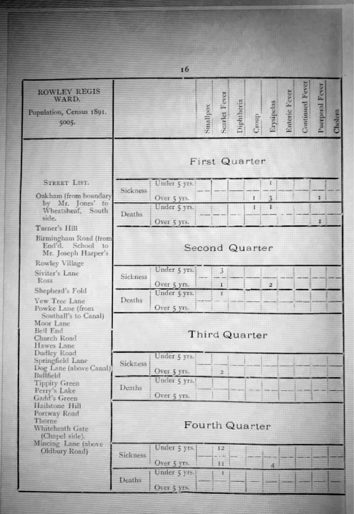
The report is extremely detailed and thorough, much of the information broken down into the Electoral Wards in Rowley Regis, which were Tividale, Rowley Regis, Blackheath, Old Hill and Cradley Heath so it is possible to look at much of the information just for Rowley Regis. Much of what follows, however, relates to the wider area of Rowley, rather than just the hamlets. Nevertheless I hope that you will find it of interest as undoubtedly the issues covered in the report relate to the residents of the Lost Hamlets to some extent. The photograph below shows the list of streets in the Rowley Ward in 1891. The population of the ward then was 5,005, it comprised 1347 acres, had 920 inhabited houses and 29 void houses.
The report also notes the number of births – 1252 in the District in 1895, there were also 622 deaths in all.
The page also shows the numbers of sicknesses of particular types – Smallpox, Scarlet Fever, Diptheria, Croup, Erysipelas, Enteric Fever, Puerperal Fever and Cholera, whether they related to people under or over five years of age, and the number of deaths resulting, all divided into quarters of the year. Fortunately in this year, there were no cases of small pox, diphtheria, enteric fever or Cholera.
There are mortality returns – 622 deaths in the year1895, 326 males and 296 female, giving a death rate of 18.7 per 1000 inhabitants. In 1894, the report says, there were 510, and the death rate then was 15.6 per 1000. The report then breaks these down by age – 243 deaths of infants under the age of one year, a rate of 7.3 per 1000 inhabitants, more than twice the rate of any other age group – 103 between one and five years, 22 between five and fifteen years, 19 between fifteen and twenty-five years, 115 between twenty-five and sixty five years and 120 aged over sixty five. None of these latter were more than 3.6 per 1000.
The infant mortality rates were a subject of much concern amongst both Council Health officers and members. The report goes on:
“Infant mortality again forces itself very prominently on our notice. Three hundred and forty six deaths under five years of age out of a total of six hundred and twenty two which had been registered. This is a very serious condition of affairs and the solution to the problem of how this waste of infant life is to be prevented does not appear to me to be forthcoming in the near future. In addition to the old conditions mentioned in my previous reports, all of which conditions still exist, a severe epidemic of Scarlet Fever has been prevalent in the District for the last eight months concurrent with which has been an epidemic of Whooping Cough and, during the last quarter and epidemic of measles. “
Smallpox
The report also notes that in the year there were three cases of smallpox, all in the Halesowen Road. In these cases, all the patients had been vaccinated against smallpox and had mild attacks from which they recovered. It is clear from the report that the medical officers made vigorous attempts to trace the origin of the infection and although all three cases were in the same street, he had been unable to find any connection between them. In the report for the previous year, I noted that there had been fourteen cases of smallpox, all treated in isolation at the Tividale Isolation Hospital.
It was noted that several were connected and from the same area of High Street and Hackett Street, Blackheath. The report notes
“All these people, in my opinion, had the disease conveyed to them by our Sub-Inspector who is brother-in-law to the first case admitted this year. I had foreseen the danger for some time and had attempted to minimise it by instructing him not to handle the patients or otherwise unnecessarily expose himself to infection, also to disinfect his own clothing at frequent intervals. This risk will always be attendant on those engaged in disinfecting clothing and infected houses.”
Poor sub-inspector. Fortunately all the patients were well vaccinated, had the disease in a very mild form and made good recoveries. Another cluster of cases in Tividale were thought to have originated with a policeman who regularly patrolled past the isolation hospital where smallpox patients were nursed.
The report noted that the Medical Officer considered that they had been very fortunate in confining the disease to the houses in which it had appeared and he attributed this success in a great measure to the prompt removal of the patients to the hospital and the thorough process of disinfection to which they subjected the houses and their contents.
There had also been one case of suspected cholera in July 1894 in Tividale and again swift and thorough measures were taken. The Medical officer says in a letter sent the same day to the Local Government Board that
“I have ordered the closets at his residence and at the works to be emptied tonight, the contents to be buried after being freely treated with carbolic powder, and the midden holes also to be freely dressed with the same powder. I have supplied disinfectants (sanitas oil emulsion) for all soiled linen to be soaked in and the first thing in the morning, shall have all soiled articles disinfected by our steam disinfector. I have removed all the occupants of the house (including two lodgers) and have left him in the care of his wife and mother.”
How thorough is that? Fortunately the man survived and recovered and laboratory tests on samples subsequently showed that the infection was not cholera. But it might have been…
Scarlet Fever – unknown for my childhood and since until quite recently – 541 cases of this had occurred in 1895, amongst 352 families with 24 deaths resulting. This was 353 more than the previous year. Fortunately most of these had been of a very mild type, hence the ‘small proportion’ of deaths. By the middle of August 1895 the outbreak had become so severe that Dr Beasley had to report it to the Local Government Board. The letter is shown in full in the report. He details his efforts to stop the spread of the disease,
“taking all the means at my disposal’ including confining patients to their homes ‘until desquamation has been completed’ (the peeling of scales of skin due to the disease), preventing children from infected houses attending any school or public assembly, disinfecting by stean disinfector all clothes, bedding etc and disinfecting all infected houses as early as possible after the convalescence or death of the patient. A free distribution of disinfectants and a strict surveillance over all notified cases.”
He also noted that one person Mary Jane Dunn – had been convicted of exposing a child in public whilst suffering from Scarlet Fever, for which they had been fined twenty shillings and costs. They were certainly very proactive in trying to combat this disease. He notes that almost all the cases were confined to Old Hill and Cradley Heath at the time (August) though it later appeared in Blackheath and Rowley Regis and was also in neighbouring areas and indeed the whole country.
Seven cases of Diptheria had also occurred among five families with one death. Again, unheard of in our modern lives, thanks to vaccinations. The Medical Officer attributed most of these cases to drainage problems and offensive drains.
Six cases of membranous croup had occurred, all isolated cases spread around the district and five of them in under fives, four deaths resulting from these.
There had been twenty one cases of Enteric (Typhoid) Fever, among seventeen families again scattered around the District though usually attributed to impure drinking water or ‘effluvia’from a night soil tip or pigstys, or contaminated wells or water supplies. He notes that the water supply to these houses had received ‘careful attention’ and other sanitary defects had been rectified.
Measles, although not a notifiable disease,had also proved a considerable problem. Eight deaths had been registered from this cause. There had been a few cases in Old Hill and Cradley Heath in the first quarter and then none until November and December when it became so prevalent that the Endowed School at Reddal Hill and the Infant Department at the Old Hill Board School had been advised by him to close a week prior to the Christmas holidays to try to slow the spread of the disease by person to person infection. A full report had been submitted to the Local Government Board again, once more included in the report, and it was stated that at Reddal Hill School, 120 children out of 610 pupils and at the Old Hill Board School, 200 out of 417 children were absent on account of some members of the various families being attacked with either measles or scarlet fever. The schools had closed immediately and would not re-open until 6th January.
This photograph shows the Preventive Measures adopted to try to contain the spread of infectious diseases.
As part of this report there is also an ‘Epitome of Sanitary Work for the Past Year’ in the report. Work was being done to provide ‘deep drainage’ throughout the District but this could not be turned into the pipes until the whole work was completed, understandably!
To improve surface drainage extra men were still employed in attending to the open ditches and water courses in the parish and 5,507 yards of ditches had been cleared out during the year. It has to be said that although parts of Oakham were included in the list of areas where ditches had been cleared out, there is no mention of any of the lost hamlets – perhaps there weren’t any ditches on the quarry side of the hill. Also 1,335 yards of kerbing and channelling had been laid on local roads in the area. It is difficult to imagine so much work being done in such a small area in one year these days.
Night soil removal was done under contract which was said to be ‘far from satisfactory’ – complaints were made of the nuisance arising from some of the tips and of the night soil being tipped in unauthorised places – the more things change the more they stay the same! Early fly tipping, obviously… In the previous April an extra assistant inspector had been appointed to look after the privies and closets in the Upper Division – which would include Rowley – and since then, complaints of delay in having them emptied has been less frequent.
There had been continuing efforts to improve the safety of water supply in the District – 261 houses had been connected to the South Staffordshire Water Company supply and two wells had been closed in 1895 and the water from fifteen tested and fourteen of those had been condemned as unfit for use. But finally a reference to Turners Hill –
Reference to the water supply to Turners Hill appears in both the 1894 and 1895 Reports.
In 1894:
“The water supply of Turners Hill and District still remains unchanged, although further very special efforts have been made to procure a proper supply from the SSWWCo for this area. It is a matter of deep regret to the Board and to myself that these efforts have been unsuccessful, notwithstanding the engagement by the Board of an eminent Water Engineer, with the hope of effecting the required supply. The Water Works Company have considered several schemes suggested by the said engineer but have not accepted any of them, nor does it seem possible to get the company to lay on their water without the payment of a very considerable sum of money, which it is feared could not be met by a rate on the locality. This particular area is rural in character but is nevertheless within that covered by the Company’s Act of Parliament. It is a great pity that the service reservoir for the parish of Rowley Regis was not constructed on this highest point of the parish so that all parts could have been supplied from it.”
And the 1895 Report has:
“In spite of all efforts on the part of the Council the water supply of Turners Hill district remains unchanged. An effort has been made to get the mains extended either from Perrys lake or Whiteheath to the lower part of Portway and Throne but without success and this part of the parish is practically without any reliable water. Two springs and a number of surface wells are the only sources from which water can be obtained.”
Inspections
In addition to all these other responsibilities Inspections had also been carried out under the Factory and Workshop Act. And 22 dairies and Milkshops had been inspected with 18 formal notices issued and 17 nuisances abated as a result. 219 Cowsheds and 131 slaughter houses, 92 canal boats and 67 pigsties had been inspected. Dwellings, houses and schools had been the subject of 281 inspections for ‘foul conditions’, resulting in 133 notices and 130 improvements, 31 buildings had been found to have structural defects , 14 to be overcrowded and 17 unfit for habitation. Of these latter notices had been issued in 15 cases and the nuisances abated. There had also been 1098 lots of infected bedding stoved or destroyed, 458 houses disinfected and 1 school and 330 houses had been limewashed. The Department had purchased a ‘Disinfector’ apparatus which was judged to be a great requisition and was performing its work ‘in a most satisfactory manner’, and public prejudice against it was said to be gradually wearing away.
Conclusions
I was struck by the diligent efforts shown in this report to prevent disease and to identify the origins, the work to improve housing, sanitation, drains etc, to make life better for local people. Taxes, it has been said, are paid with resignation, rates are paid in anger and it is certainly true that, in my experience as a local government officer, many people find it hard to identify the services which their rates pay for. But I don’t think that this can have been said then. There appears to have been quite a small team making a very strong effort to improve people’s lives and to assist those afflicted by infectious diseases and to remove the causes where these could be traced back to environmental issues.
I am also sure that it is not insignificant that the people sitting on this board were local people, they lived here, they worked or had their businesses here, they met the local inhabitants at their churches and chapels, in the shops, as their neighbours – they knew them. These were not ‘jobsworths’ doing this for the sake of looking good, of being a committee member, this committee also had a vigorous committed professional staff who, frankly, appear to have been working their socks off to improve the living conditions of local people, and many of them appear to have stayed in their posts for many years. So they knew their area intimately. I have the impression that they achieved an enormous amount given the limitations of scientific knowledge then.
I wonder, has local government been greatly improved by combining authorities into bigger and bigger councils so that your representatives will certainly not have the local knowledge and commitment that these people did?
These reports show a very detailed picture of the public health concerns of local councils at this time and by looking at later reports it is possible to see great changes and to appreciate why some courses of action were taken in slum clearance and demolishing houses in later years. I will look at a couple of later reports in a later post, some of the changes are very striking.
To read some of the reports for yourself, go to the Internet Archive at archive.org and search for “Rowley Regis” and specify ‘texts’. You can also limit it by dates so I searched from 1850 – 1970, lots of interesting results and many of these reports.
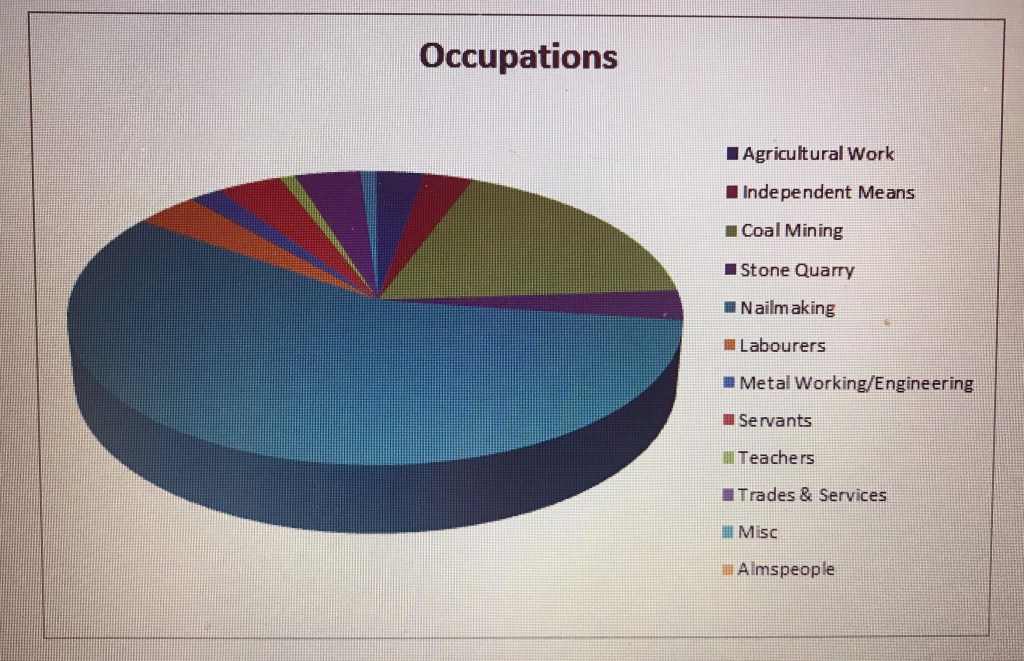
The population of Perry’s Lake, Gadd’s Green, Turner’s Hill and Tippity Green had expanded to from 384 to 412 since 1841. But there was more variation in jobs than in 1841 and more occupations were shown for women. Scholars were also noted, though not many and these are detailed in a later chart.
Occupations
Agricultural Labourer 3
Almspeople 2
Annuitants 4
Boat Loader 1
Butcher 1
Coal miners 36
Colliery Clerk 1
Dressmaker 3
Engine worker 1
Engineer 1
Errand boy 1
Farmer 1
Farm Labourer 2
Female Servant 4
Furnace Labourer 1
General Servant 5
Labourer 8
Laundress 1
Man servant 1
Mine agent & Surveyor 1
Nailer 117 57 W, 60M
Nail Master 1
Nail Reckoner 1
Nailer’s Tool Maker 1
National School Teacher 2
Needlewoman 1
Nurse 1
Proprietor of Lands 2
Puddler 1
Retired nailer 1
Stone Cutter 4
Stone labourer 2
Stone miner 1
Turnpike Gate Keeper 1
Victualler and butcher 1
White ash maker 1
So the number of different occupations has changed since 1841, some with only I or two people.
Nail making is still the dominant occupation, with miners the only other numerous group. The numbers of men and women are about equal. In most of this group the enumerator describes people making nails as ‘Nail forgers’, a recognition that they were skilled workers producing wrought iron nails in their forges, though another enumerator still calls them simply ‘nailers’. It is possible that some women and children made nails and simply did not declare it, also that some men made nails when other work was not available (such as agricultural workers in winter) or when they got home from work, so the number of nailmakers may be understated.
Other metal working trades such as a furnace labourer and a puddler are noted so skills were diversifying as new industries expanded or moved into the area.
Stone quarrying is not as big an employer as I had expected although it is possible that some of the labourers worked at the quarry and had not specified that, in addition to those who were listed with a specific stone working skill.
Professionals such as an engineer, a Mine Agent and two teachers (brother and sister) have appeared. The former Census showed John Whitehouse as the Registrar of Births and Deaths but in this Census his wife is shown as a widow so presumably this role passed to someone else.
The ‘nurse’ was a child of 8.
The Bull’s Head in Tippity Green was a public house, dating from 1834, though owned by the Dudley family and Benjamin Bowater is listed as ‘Vittler and Butcher’ in Tippity Green in this census, presumably at the Bull’s Head –and the name may have come from Benjamin’s alternative occupation! Publicans were ‘Licensed Victuallers’ so this fits. Hitchmough’s invaluable guide to Black Country pubs lists Joseph Bowater as Licensee from 1834-1854. There is no Joseph Bowater listed in the hamlets in this census though there is a Joseph Bowater who was landlord of a pub in Cradley Heath so perhaps it was a family occupation. Benjamin Bowater also had another butcher and three servants living in his household so could divide his time between butchery and inn-keeping. According to Hitchmough, The Portway Tavern was licensed premises from about 1850, according to Hitchmough with James Adshead Levett Snr and Jnr and then William Levett holding that licence for the next half century. There is no mention of a tavern in the census or of a licensee. It is possible that the Tavern was already operating informally as a pub at the time of this census, the Levetts who ran it later were based at Brickfield Farm in 1851 though away from home on the census night.
For the chart I have combined the jobs associated with nailing and other occupations into groups.
Where did people come from?
Binton, Warwickshire 2
Gloucestershire, St Briavels 1
Herefordshire 1
Lancashire 1
Leicestershire, Mountsorrel 6
Shropshire, Old Park 1
Shropshire, Broseley 1
Shropshire, Stottesdon 1
Somerset, Wellington 2
Staffordshire, Rowley Regis 364
Staffordshire, Sedgley 1
Staffordshire, Tipton 4
Staffordshire, Wednesbury 1
Staffordshire, Wednesfield 1
Staffordshire, West Bromwich 1
Staffordshire, Tettenhall 1
Staffordshire, Tipton 2
Warwickshire, Birmingham 6
Warwickshire, Coventry 1
Warwickshire, Nuneaton 1
Warwickshire, Sambourn 1
Worcestershire, Dudley 6
Worcestershire, Halesowen 2
Worcestershire, Oldbury 1
Worcestershire, Wychbold 1
Again, the great majority are from Rowley itself, with a sprinkling from the surrounding area. Looking at other places, such as Mountsorrel in Leicestershire, I was interested when I looked this up to find that it was renowned for its granite quarry, just like Rowley Regis, so presumably the skills required were transferable. St Briavels in Gloucestershire was in the heart of the Forest of Dean Free Mining area so again there was a common industry.
How old were they?
Men Women
Age
80+ 1 –
75-79 1
70-74 1 5
65-69 1 1
60-64 3 3
55-59 2 3
50-54 9 10
45-49 9 7
40-44 8 9
35-39 12 6
30-34 11 12
25-29 19 20
20-24 27 18
15-19 26 18
As in the 1841 Census, not many lived much past sixty.
Younger people under the age of 15
14 3 5
13 2 3
12 4 5
11 2 4
10 5 7
9 7 6
8 5 4
7 9 5
6 1 5
5 9 3
4 3 7
3 8 9
2 4 5
1 7 7
-1 5 7
74 boys, 82 girls.
Scholars by age
Boys Girls
13 – 1
12 1 1
11 – 1
10 3 1
9 4 1
8 2 1
7 5 2
6 1 –
5 2 1
4 – 3
18 boys out of 74 and 11 girls out of 82 were at school. We do not know how many children were at school in 1841 but this shows that schooling was still far from the norm. Literacy was very much the exception, especially for girls, it seems and from the age of about eight, children were making nails and some were employed outside the home in quarries and mines.
I hope these statistics will be of interest. There will be more for the later censuses, as I transcribe and analyse them. Apologies for the poor quality images – technologically challenged author here, though creating charts is new for me so I am learning!
Hopefully, as more censuses are done we shall be able to see the occupations change over time and I hope to do more detailed work on the families there.
In 1841, the population of Tippity Green, Perry’s Lake, Gadds Green and Turner’s Hill numbered 384.
The occupations listed for them were:
Blacksmith 1
Butcher 1
Coal Miners 13
Farmers 5
Female servants 8
Forge filer 1
Independent means 1
Ironmonger 1
Jobbing Smith 1
Labourers 9
Male Servants 5
Nail factor 1
Nail tinner 1
Nailmakers 38
Publicans 1
Registrar of B&D 1
Shoemaker 1
Stick dresser 1
Warehouseman 1
Wash for hire 1
A couple of entries have no occupation shown, this may be because those men were out of work or simply an omission.
Nailmaking was by far the dominant occupation, coal mining was not yet a major employer . Very few occupations were listed for women unless they were widows, despite the fact that most women and many children also made nails at this time. No scholars were listed though that may not mean that no children went to school, there was at least one school in Rowley Regis at this time, it simply may not have been recorded.
Note that the local Registrar of Births and Deaths John Woodhouse was living in Tippity Green, his son William would succeed him in that role in due course. I have many copy certificates of births and deaths with their signatures.
There appear to have been few shopkeepers at this time, people had to be self-sufficient or buy necessities from further afield, although there may have been some informal grocery shops in front rooms! Many households would have kept chickens and pigs and may have acquired the occasional rabbit for the pot, and presumably grown vegetables if they had gardens.
Where were they from?
Only 46 of the 384 were born outside the County of Staffordshire.
Of these 46 only 10 were born in Scotland, Ireland or Foreign Parts. 5 men and 5 women. No information is shown in this census about where others came from but more is shown in later censuses.
How old were they?
Ages in the 1841 Census were supposed to be rounded down to the nearest five years. So if you were 38, your age was shown as 35. A trap which can mislead family historians who are not aware of this and who are looking for an ancestor of a particular age. And at this time ordinary people were often neither literate nor numerate so ages in this Census should be treated with caution
In this chart the ages are shown along the bottom. As it shows, it appears that living beyond 50 was good going and beyond 60 was a rarity. Two of the four aged 75 were men living in Tippity Green in the Parish Poorhouse, one of them blind, the first woman was living on Turner’s Hill, the ‘wash for hire’ listed in the occupations and the second woman was living alone in Perry’s Lake. But with no pensions, most people worked for as long as they lived.
Ages of adults:
Adults’ Ages in the 1841 Census
Younger people
The Census required the ages of those under 15 to be shown by year, perhaps to enable the Government to track child mortality.
Children’s ages in the 1841 Census
Transcribing burial records for Rowley Regis has shown me that great numbers of babies died – of debility, decline, lung and bowel problems – before their first birthdays. These will often not appear at all in Census records if their short lives fell between censuses. And older children succumbed to whooping cough, smallpox, measles, scarlet fever, typhus fever (as did numerous adults) and consumption (Tuberculosis). Poor nutrition, cramped living conditions and exposure to smoke and air pollution would not have helped.
My apologies for the poor quality of some of these images: I am new to this medium and on a steep learning curve, I hope this will improve as I become more accustomed to it.
So these are the basic statistics for the population of the lost hamlets taken from the 1841 Census. In future posts, I will explore more about the families behind the numbers.
There are 13 families who were living in the hamlets of Perry’s Lake, Gadd’s Green and Turner’s Hill area for all five censuses which I have so far transcribed. All are familiar Rowley names:
Cole, Cutler, Darby, Foster, Hill, Hipkiss, Levett, Parkes, Redfern, Simpson, Taylor, Whitehall/Whittall and Woodhouse.
A further 9 families had moved in between 1841 and 1851 and were in all four of the 1851-1881 Censuses:
Another place name in Rowley Regis which has had the same question asked about where it was is ‘Finger-i-the-hole’. Where was it? Why was it called that?
The name first appears in the Parish Registers in December 1727 when ‘Christopher Chambers of ye ffinger-i’-the hole’ was buried and the name crops up in later years with different spellings in various records, including the 1841 Census, when twelve families were living there. Later references to it seem to have reduced it to Fingeryhole. The local consensus in discussions on the Facebook page was that it was somewhere on Turner’s Hill.
J Wilson-Jones, in his book, The History of the Black Country recounts this story:
“Upon the Rowley Hills stands an old Cottage known as Finger o’t’Hole. It was so named because old Black Country cottages had a drop latch fixed upon their doors, it could be opened from the outside by putting the finger through a round hole. At this cottage there lived an old lady and one night a robber thought to take advantage of her loneliness. The cottage being in darkness, he placed his finger through the hole but the old lady had been disturbed and was waiting with a poised hatchet. The robber lost his finger and the cottage was named Finger o’t’Hole.”
So that legend obviously goes back a long way.
This appears to be the sort of latch referred to in the story, with a finger hole! (Photograph courtesy of Creative Commons).
When I came to transcribe the 1841 Census, I was not able to find any mention of Gadd’s Green, although Turner’s Hill and Perry’s Lake were easily found. By following the census enumerator’s route, which appears on the first page of each set, I found that Finger-i-the-hole appeared to be in the same geographical position as Gadds Green was in the 1851 and later censuses, after Perry’s Lake and before Turner’s Hill.
Transcribing the 1841 Census showed that the families living in Finger-i-the-hole in 1841 were :
William Priest (+2) 45 Nailmaker
Joseph Taylor (+5) 40 Nailmaker
Thomas Hill (+8) 45 Nailmaker
John Hipkiss (+14) 70 Nailmaker
Joseph Whitehall (+6) 59 Nailmaker
Philip Taylor (+4) 35 No occupation shown
William Woodall (+2) 45 Nailmaker
Pheby Whitehall (+2) 30 Nailmaker
David Priest (+5) 35 Labourer
Jos’h Hill (+3) 20 Coal miner
Elizabeth Morton (+6) 35 Nailmaker
John Simpson 20 No occupation shown
And every single one of these families appeared in the 1851 Census with the name of their abode given as Gadd’s Green! So – even if the origin of the story of Finger-i-the-hole related to one cottage – from references in the Parish Registers and from the 1841 Census, by the early 1800s the name referred to a whole group of dwellings.
I hope to add the whole of the 1841 and later Censuses for these hamlets in due course so that family members can be seen. The 1841 Census is the least detailed and informative of the censuses, often difficult to read as it was completed in pencil. Also, the ages of adults were supposed to be rounded down to the nearest five years and no relationships were shown. Later censuses were much more informative.
So at last there is an answer to the question, where was Finger-i-the-hole? It became known between 1843 – the last reference to Finger-i-the-hole in the Parish Registers – and 1851 when it appears in the 1851 census – as Gadd’s Green.
It is probably not a coincidence that the Rev’d George Barrs died in 1840. He had been a vigorous and campaigning Curate in charge of the Rowley Regis Parish from 1800 until his death and in those forty years must have built up extensive knowledge of local people and places and would have known local names. Perhaps succeeding newcomer curates to the parish found the name Fingeryhole (and the story behind it) fanciful or unacceptable in those very proper Victorian times.
There were certainly Gadds in Perry’s Lake in 1841 and 1851 so it’s possible they were connected and the name came from land they owned there, some further research into deeds may one day give more information. Interestingly, there were also Gadds, rivet makers, living in Ross, an old street on the other side of the village, in 1841 where later Thomas Gadd founded his rivet making factory. The factory was still there in the 1950s and 60s, and including the original cottages, as I passed this factory on my way to and from the library. I now know that my great-grandfather Absalom Rose worked there.
As I keep saying, folk tended not to move around much!