Edward Alsop, of Alsop’s Hill and Alsop’s Quarry, died, aged 78 and was buried at St Giles on 7 September 1860, his abode given in the Burial Register as Blower’s Hill. Does anyone know where this was? I didn’t! And no-one in the local Facebook page knew either when I appealed there. But clearly the name was quite unremarkable to local officials who recorded information in parish Registers, compiled Poll Books and drafted Wills. They must have known where Edward was referring to. But I was puzzled, I had seen nothing to indicate that Edward had moved anywhere else, he appeared to have lived all of his life in the Windmill Farm. But I could not find Blower’s hill on any maps or in any online archives.
So I have been exploring down a little local history and genealogical rabbit hole, trying to find out where Blower’s Hill was.
Blower’s hill
The spelling and punctuation vary slightly but usually the Alsop family appear to have spelled Blower’s with an apostrophe – making Blower’s a possessive adjective. And often they did not capitalise Hill, as if it were just a description of part of the landscape, rather than a defined area.
I considered various issues:
What had this area been called before the Alsops arrived?
First of all, although the land there was known later as Alsop’s Quarry or Alsop’s Hill, it must have been called something before the Alsops came along in the mid-1700s. And it would probably have taken a few years/decades/generations of the family living there before it became associated with their name. Even then, although many records and maps show the land they farmed as Alsop’s Hill or Alsop’s quarry, the family appear always to have called it Blower’s hill.
So perhaps the earlier local descriptive name was ‘Blower’s Hill’, either for the windmill, which was apparently a manorial mill, so long established there.
Copyright: Glenys Sykes – my artist’s impression of Blower’s Hill!
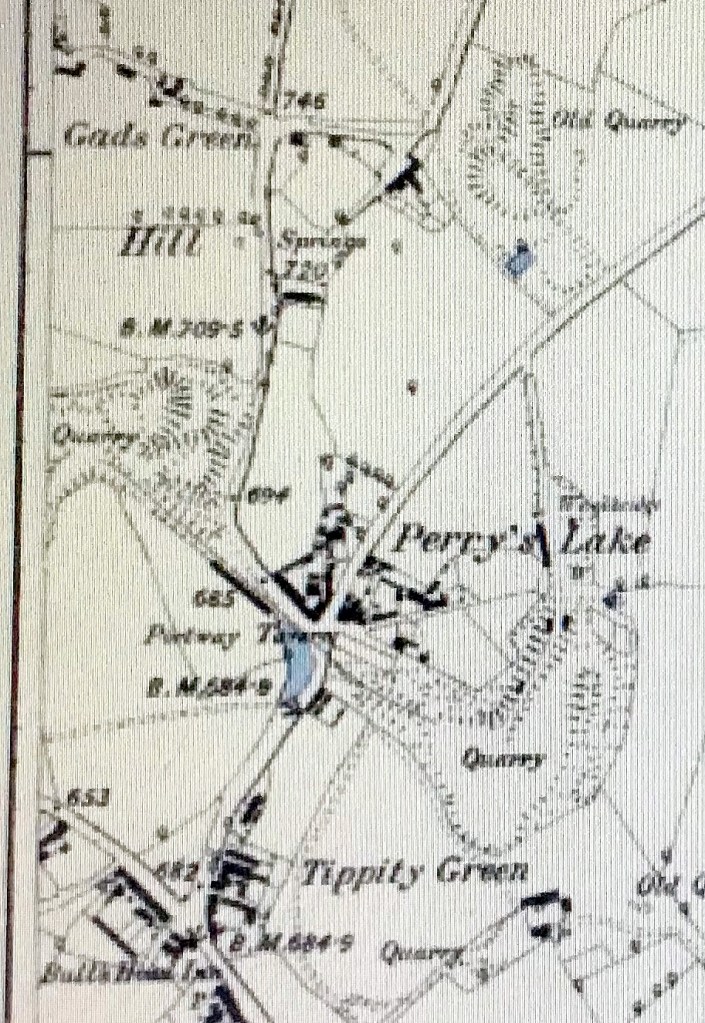
Or perhaps the land was known by the name of a previous owner, since mostly the Alsops used a possessive apostrophe in the name and it was very common in this area for places to be named after their owners, such as Gadd’s Green, Darby’s Hill, Perry’s Lake, etc, etc.
So – were there any Blower families locally?
I searched all four volumes of the Rowley Parish Registers (1539-1849)for the name Blower and found just one! In 1573. a Thomas Davies married Agnes Blowere. So at some point there was at least one person called Blower or Blowere known of in the parish even if it was 200 years earlier! But when I extended the search on FreeREG to surrounding parishes (including 100 additional places within 7.5 miles) I found that , between 1750 and 1850 there were 314 entries of baptisms, marriages and burials in surrounding parishes. There were Blowers in Harborne, Halesowen, Wombourne, many, many in Penn, others in Oldswinford, Brierley Hill, Dudley, Sedgley, and especially latterly, in Bilston and Wolverhampton. Most of those are on an arc to the west of Dudley, between Harborne and Wolverhampton.
I was especially interested to note the marriage of a Susannah Blower to Joseph Hill at Clent in 1769, Rowley was a chapelry of Clent and quite a lot of Rowley people married there. And, of course, there were lots of the Hill family in the Lost Hamlets. And I also noted the marriage of Letticia Perry to John Blower in Sedgley in 1825 – hmmm, Perry’s Lake/Blower’s Hill, are immediately adjacent to each other in Rowley – interesting, perhaps their families had property interests in common!
So although there were very few Blowers in Rowley Regis in later centuries, there were plenty in adjacent areas.
The Electoral Records
Second: Another important clue lay in the Poll Books. Edward was shown in the 1837 and later Poll Books consistently with a house and land at this address, which was described as Blower’s hill Farm. I found Poll Book entries as early as 1837 – just after electoral reform had been enacted which would have given Edward the right to vote – and all of these identify his only property in Rowley Regis Parish as Blower’s hill farm, which was a house and land occupied, implying it was being farmed.
These voting rights were an important part of political and social reform in 19th century Britain. There are interesting articles with further information here ( https://www.nationalarchives.gov.uk/education/resources/what-caused-the-1832-great-reform-act/ ) and here(https://en.wikipedia.org/wiki/Reform_Act_1832 ), and on numerous other pages. But it was not universal suffrage, the vote given to all men (and certainly no women!). The right to vote was extended to small landowners, tenant farmers, shopkeepers and all householders who paid a yearly rental of £10 or more. So the holding of property had presumably been checked before being recorded in the Poll Books.
What did the family call it?
Thirdly, at least Edward’s generation of the family were calling it ‘Blower’s hill’, rather than Alsop’s Hill or Windmill Hill, over many years.
Answering my own question!
So I have gone through again all of the records I have found for Edward Alsop, looking carefully at the descriptions in those records.
And, finally, fourthly, looking carefully at the wording of the Probate record for Edward’s Will, shown here, it actually says that he is ‘late of the Mill Farm Blowers-hill in the parish of Rowley Regis.’ And his son Thomas and daughter Rhoda, as executors, are said to be ‘of Blowers-hill aforesaid’.
Copyright: Probate Office.
Which shows, it seems, that Blowers-hill was the name by which the area of land farmed by the Alsops was previously known, and that it and the Mill farm were one and the same place.
Another old Rowley place-name detected and, I believe, placed geographically, at least on my mental map!
Over the last few weeks, I have been doing some of the basic preparation work for more possible family studies, for the Hipkiss and Whittall families. This is going to be a slow painstaking task, as they were quite prolific and, especially for the Whittalls, the spelling variations make this quite challenging. But I have done a lot of searching through censuses and parish records and made pages and pages of notes. And I am nowhere near ready to write either of them up but I needed a break from the Hipkisses and Whitalls!
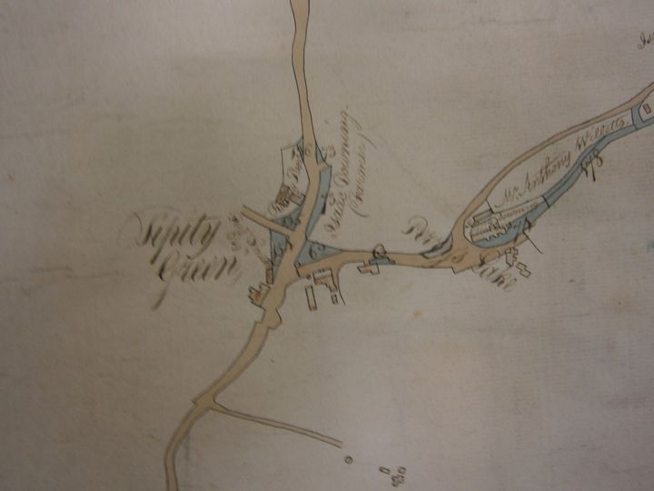
So I decided to take a temporary diversion and look at something quite different, to give my brain a rest! I decided to look at the farms in the Hamlets in the 1841 census, starting with Windmill Farm at the junction of Hawes Lane and Tippity Green, the Alsops , millers and farmers, newish (by Rowley standards) to the parish, smallish family, no connections to my tree. Very refreshing.
Copyright: J Wilson Jones.
Ibberty or Tippity Mill, Wilson Jones calls it the Manorial Mill and this is presumably the Mill which the Alsops operated. This photograph appears in his book A history of the Black Country and he appears to have taken the photograph himself. There is no indication of when this was taken but the book was published in about 1950. However, the Mill does not appear on the 1902 OS map so perhaps it was a photograph he acquired from someone else.
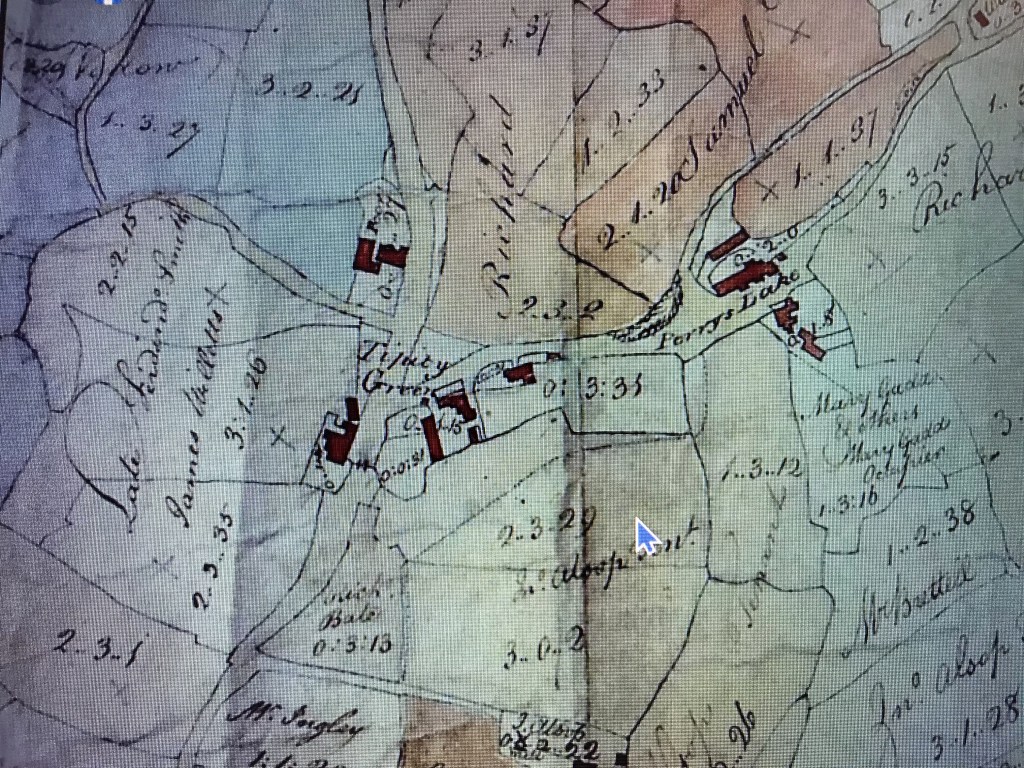
Copyright and date unknown but I think this map is part of a copy of the map drawn up before 1800 for the Rowley Regis Enclosures. You can see that John Alsop was renting quite a bit of land here which subsequently became Alsop’s quarry. And in the middle at the bottom is a small oblong which has the name J Alsop , the word Mill and a little diagram of a windmill above the word Mill, although almost obscured by the plot number. So this shows where the Alsops were living, milling and farming. The Mill appeared to have an access road, too which has subsequently disappeared, unless, of course, it later became the site of the Club Buildings? The Alsops had arrived in the parish by 1734, possibly as Millers as there are various Alsops in nearby areas who were also millers.
But, as so often happens, when I got started on the Alsops, they turned out to be quite interesting and worthy of a post of their own to my blog (to follow soon!). And as I started to gather information on the children of Edward Alsop, who was the farmer there in 1841, I found that his second son Joseph had married a Sarah Eliza Dingley and was living in 1841 at the bottom of Rowley Village where he was a shopkeeper.
Straightforward enough so far, and I was interested to see the Dingley name, as I was at school with a Geraldine Dingley, back in the 1960s and I hadn’t come across it in other researches. Because Sarah Eliza had given her full name in the Census, I was able to find her marriage easily on FreeREG, she had married Joseph Alsop at Clent in 1832. And, as I could calculate her birth year from later censuses, I found her baptism on 25th December 1812 at Halesowen. She was the daughter of Ira Dingley (1789-1864) and Elizabeth nee Cooper (1788 -?), the eldest but one, I found, of about ten of their children baptised at Halesowen church. That sounded good, Ira is a relatively unusual name so should be easy to trace. As indeed he was. We will ignore for now that there were at least three more Ira Dingleys to follow in short order, son and grandsons which did complicate sorting them out later. But never mind…
This family all baptised their children at Halesowen, this was before Blackheath St Paul’s was built but they lived in the Hill area of Blackheath, Long Lane, Cocksheds, Gorsty Hill, Malt Mill Lane.
There are clues in these names, I think – Gorsty Hill was probably rough heathland with lots of prickly gorse bushes, the Long Lane really was a long lane leading from Rowley all the way to the King’s Highway at Quinton, there must have been some poultry business at Cocksheds and a brewer’s Malt Mill somewhere in the area – most pubs brewed their own beer but they needed Malt and therefore maltsters.
I was able to find this later Ira’s children William (1810-1842), Sarah Eliza (1812-?), Elisabeth or Betsy (1815-?), Ira (1819-1855), Henry (1822-1885), Paarai (1823-1905), Neri or Nari (1829-?), Edmund (1829-?) and Edward (1830-?). Imagine what it would have been like in that household? Two people called Ira, one called Paarai and one called Nari? Did you shout for me? Recipe for confusion…
I was particularly interested in Nari or Neri, that really is an unusual name. But I do have two other Neris on my family tree – my great-grandfather and great-great-grandfathers were both Neri or Nari Ingley or Hingley – my aunt knew her grandfather and pronounced his name ‘nar-eye’ but he usually spelled it Neri.
How about that for a coincidence? Neri Hingley/Ingley and Neri Dingley, both living within a mile of each other? They must have known each other, surely?!
Neri Ingley /Hingley
So my 2xg-grandfather Neri Ingley (1824-1901) – the spelling varied between Ingley and Hingley for quite a long time about this period – was baptised in 1824 at St Giles, the son of John Ingley and Mary nee Hackett of Old Hill. This Neri married three times – to Mary Slim (1827-1861), with whom he had eight children, then to widow Ann Aldridge nee Whitehouse ((1823-1869) with whom he had my great-grandfather Neri (1862-1934) and finally to Maria Taylor (1832-1906) with whom he had two more sons. Busy lad.
Just to complicate my family tree, Neri Ingley was my 2xgreat-grandfather through Ann Whitehouse and their son Neri, but his third wife Maria Taylor was also my 2xgreat-grandmother through her first marriage to James Hewitt and their son Joseph. Although the 1861 Census just gives the abode of James and Maria Hewitt simply as Blackheath, they were living next door to William Taylor, who was Maria’s older brother and his wife Phoebe (and his step- daughter Sarah Whittall) and next to them was William Dingley, followed by the Hadley family so it seems very likely from this juxtaposition of families that they were living in this same area around the top of Gorsty Hill as in 1881. And the enumerator, in the description of his route, states that he was starting from the market place in Blackheath and covering both sides of the road towards Halesowen, to the top of Gorsty Hill which confirms this.
Lots more to untangle there – and another Hipkiss!
Neri Dingley
Neri Dingley was born a few years after Neri Ingley, he was baptised at Halesowen in February 1829, the son of Ira Dingley and Elizabeth nee Cooper. I have been unable to find any trace of him after his baptism, he is not listed with the rest of his family in the 1841 Census, he has disappeared. After a lot of checking and head scratching, I have come to the conclusion that Edward Dingley, apparently born about 1830 and Nari may be the same person. Edward appears in the 1841 Census, aged 10, as a son of Ira and Elizabeth but there is no baptism for him, I have checked all the way through the Halesowen Registers. Ira and Elizabeth Dingley had all of their other children baptised, why would they not have Edward baptised? And when Edward marries Matilda Johnson in 1856 he gives his father’s name as Ira Dingley. And he names his second son Nari. I can’t prove it but I suspect Ira became known as Edward.
Ancestry Hints
Perhaps this dearth of information about Nari/Neri Dingley accounts for some confusion. When I started to research this Neri on Ancestry, I was pleased to see that there were 14 hints for him, as although I always check sources for these hints, they can be useful shortcuts. This number of hints is often a sign of someone who has already been fully researched by others and it is possible to check their sources to satisfy yourself that you are researching the same person.
But when I looked at the hints, they all related to Neri Hingley, not Neri Dingley. I know because most of them referred back to my original research on Neri Hingley which had been faithfully copied by someone else! But it did throw me for a little while. They were definitely not the same person. Surely the two men had no actual family connections? I had not found any in my forty years of family history research.
The Dingley family in Long Lane/Cocksheds Lane
While I was doing the basic research on the family of Sarah Eliza Dingley, which was where I first came across the Dingleys, I found myself looking at her older brother, William Dingley, (1810-1842) and filling in his family. There were a number of Dingleys living in Cocksheds Lane, Gorsty Hill, Malt Mill Lane and Long Lane, over a number of decades, another family who tended to settle near each other. One census record in 1881 caught my eye.
Ira Dingley(1836-1894)
Amongst the children of William Dingley and his wife Rebecca nee Hadley, was another Ira Dingley , Sarah Eliza’s nephew who, in the 1881 Census, was living with his wife Phebe and their daughter Eliza in Malt Mill Lane. They had had seven children between 1854 and 1873, with most of the familiar Dingley names, including yet another Ira (1869). Checking for the marriage of Ira and Phebe, I discovered that they had married in 1858 in Halesowen church and that she was a Hipkiss, the daughter of Thomas Hipkiss, nailer. I just can’t get away from Hipkisses, it seems, they lie in wait for me and leap out when I’m not expecting them.
Copyright: Mark Bryan who posted this picture of Malt Mill lane on Facebook in 2015. He thinks it was taken about 1900 and it appears to feature a Chapel Witness Procession, possibly for Whit Sunday. (I wonder whether the little building on the far right was the Malt Mill?)
And the Whittall family
The Whittalls lie in wait, too, it seems. Because by the time of the 1881 Census, Ira and Phebe were living in Malt Mill Lane, next door to a Joseph Whittall, his wife Ann and their son James, Joseph born in Gorsty Hill, Ann in Old Hill and James in Blackheath. No direct connections obvious there, I thought, though worth some more checking.
Also living with Joseph and Ann was a Hannah Taylor who was shown as Joseph’s sister-in-law and her son Joseph Taylor who was 3 years old. Joseph’s place of birth was Cocksheds, so he hadn’t moved far. His mother Hannah gave her place of birth as Chalford, Gloucestershire. That stopped me in my tracks. I already had a Hannah on my tree who was born in Chalford, Gloucestershire – that seemed a strange coincidence – was this the same Hannah? It was indeed. The name had stuck with me because I live only a few miles from Chalford now and know it well.
The Aldridge family
Hannah Aldridge had married Benjamin Taylor in 1872 and she was my great-great-aunt, the daughter of Ann Aldridge (1823-1869) who had been born in Rowley Regis but married a canal boatman David Aldridge from Chalford , Gloucestershire in Dudley in 1846 and had borne him two children, George Aldridge (1848-1908) and Hannah (1850-?) in Chalford before he died in Dudley in 1855, whereupon she had obviously moved back to the Black Country with her two children. In 1841Ann had been living with her mother Hannah (nee Hodgetts) and step-father James Bird, her mother’s second husband, and she was living with James and Hannah again in Blackheath in 1861 (having been in Chalford with her husband in 1851). Ann’s maiden name was Whitehouse, the daughter of Joseph Whitehouse (1799-1828).
So, if Hannah was the sister-in-law of Joseph Whittall, how exactly was she related to him? Well, Joseph Whittall was the step-father of Benjamin Taylor, Hannah’s husband. Joseph’s wife Ann Whittall in this census had previously been married to Samuel Taylor who had died in 1852. What was this Ann’s maiden name, I wondered? I checked my family tree again. She was AnnIngley – daughter of John Ingley and Mary nee Hackett. So … Ira Dingley was living next door to Ann nee Ingley who was the sister of Neri Hingley.
But that was not the only link in this complicated family. Ann Whitehouse, mother of Hannah, had married again, after the death of her boatman husband. In April 1862 Ann Alldridge had married – taraaah! – none other than my great-great-grandfather Neri Hingley. So HannahTaylor, nee Aldridge was Neri’s step-daughter. Hannah was living with her step-aunt in 1881. I’m not sure how that made Hannah Taylor Joseph Whittall’s sister-in-law as I reckon she was his step-niece in law but she was certainly family of some sort! And Ann Whitehouse/Aldridge/Hingley’s son Neri Hingley (1862-1934) had married Phoebe Hodgetts (1865-1922) and had five daughters including my grandmother Beatrice Hingley.
There are two pages of the 1881 Census for Malt Mill Lane which read like a list from my family tree, this seems to have been another area where, once carefully examined, everyone was related to everyone else. Margaret Thompson, your great-grandparents George Eades and Elizabeth nee Harris were on the previous page, so no doubt these families would have been well known to them.
So, I finally arrived at the conclusion that (a) my attempt to move away, for a while, from researching Hipkisses and Whittalls had not really succeeded (and may never quite succeed) and (b) Neri Dingley and Neri Hingley may not have been related by blood but their families were certainly living very close if not next door to each other in the Gorsty Hill/Cocksheds area over a period of several decades and must have been closely socially intertwined. Neri Dingley may even have been named after Neri Ingley/Hingley, as he was born a few years after him.
I think I’ve worked it all out, made all the links, for now. But I have barely started on the other Dingleys so there may be more links to come!
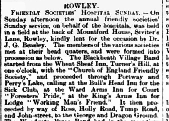
“On Sunday afternoon the annual friendly societies’ Sunday service, on behalf of the hospitals, was held in a field at the back of Mountford House, Siviters Lane, Rowley, kindly lent for the occasion by Dr. J. G. Beasley. The members of various societies met at their headquarters, and were formed into a procession as below.
The Blackheath Village Band started from the WHEAT SHEAF INN, Turners Hill at one o’clock, with the Church of England Friendly Society, and proceeded through Portway and Perrys Lake, calling at the BULLS HEAD INN for the Sick Club, at the WARD ARMS INN for Court Foresters’ Pride, at the KINGS ARMS INN for Lodge Working Man’s Friend. It then proceeded by way of Ross, Holly Road, Tump Road, and John Street, to the GEORGE AND DRAGON Ground.
The Woodgate Brass Band had in the meantime covered its route from the OLD BUSH INN, Powke Lane, with Court Little Band of Hope, calling at the MALT SHOVEL INN for Lodge Lily of the Valley, the VINE INN for Court Mistletoe Bough, proceeding along Station Road to the RAILWAY INN for Court Britannia’s Pride, thence through Halesowen Street, Tump Road, and Hackett Street, meeting the other Courts at the GEORGE AND DRAGON Ground.
A united procession was then formed, and marched to Siviters Lane, reaching the ground at three o’clock. The proceedings opened with the hymn ‘All people that on earth do dwell,’ after which the Chairman (Mr. E. Pewtress, CC) delivered a short address.
The Rev. C. W. Barnard, MA, Rector of Kings Norton, then addressed the meeting, after which the hymn ‘Lead, kindly light,’ was sung. Addresses were also delivered by the Revs. W. Hall and N. Haigh, of Blackheath.
At the close a collection was taken on behalf of the Dudley Dispensary and Birmingham Eye Hospital. It amounted to £11 9s 5d.”
When I came across this article in the local paper, I was interested that there were so many active friendly societies in the area so I found out a bit more about them. The internet is my friend…!
Friendly societies, in those days before general employment benefits and social security, were mutual aid societies which provided social and financial support to their members when they were affected by illness, unemployment or death, when widows were supported. Originally they were associated with trade guilds but later became independent organisations. They also organised social events such as the one above which must have been quite a colourful sight. I suspect most of the societies would have had their own banners and there was probably some friendly rivalry, too. Like Building Societies – such as our very own Rowley Regis Building Club which built the Club Buildings, these societies mushroomed during the late 18th and 19th century.
Many of our forebears in this area and period would have lived in dread of ending up ‘on the parish’ or, even worse, in the Workhouse, being ill or injured and unable to support their family or having a ‘Pauper’s funeral’. Membership of a Friendly Society offered some hope of avoiding these fates.
There were thousands of different friendly societies, of different sizes and not all of long duration. Smaller and early societies could struggle to calculate their insurance risks fully and to build up sufficient reserves. Events such as epidemics of infectious disease or mass unemployment could lead to the closure of such societies and the loss of members’ contributions which must have caused great dismay.
There were three main types: trade societies, local societies and interest-group societies. Some ‘Orders’ such as the Ancient Order of Foresters, which started in Yorkshire, opened branches in towns and villages across the country which allowed members to move their membership if they moved for work and also enabled risk to be spread, such as if a large employer closed suddenly. These branches were usually known as Lodges but the Foresters called them Courts and there are several Courts mentioned in the list in the article. Some local friendly societies still exist and others moved into more formal life insurance.
To become a member, men (women were not admitted, at least until the late 1800s) had to formally apply, be proposed by an existing member who would propose them and another who would second them. They had to complete declarations about health, including whether any near relatives had died of tuberculosis or if they had had certain other diseases, such as gout, rheumatism, smallpox, etc. The club doctor would also examine candidates and admission depended on his approval, all of this to limit calls on club funds arising from chronic illness. Some societies only admitted members with a weekly wage of at least 22 shillings and many trades were excluded as “any other occupation that the committee may conceive dangerous or injurious to health”. It seems to me that most of the occupations of local residents in Rowley came under this last definition but nevertheless there were clearly enough members to support a number of local societies.
I would hazard a guess that most of the societies listed in the article were, apart from the Church of England Friendly Society, fairly small local organisations. The six main large societies were the Royal Standard, the United Kingdom, the United Patriots, the London Friendly, the Royal Oak and the Hearts of Oak. None of these was mentioned in the description of the march but probably the poor wages of nail makers working from home and the hazardous working conditions in quarries, mines and foundries precluded many local people from membership, even if they could afford the contributions but smaller local societies were perhaps more flexible.
In the late 1800s clubs began to be set up exclusively for women who earned an income independent of their husbands. These clubs paid out on confinement with a child but again strict rules were set out and unmarried mothers were usually excluded.
Legislation
The administration of these friendly societies was regulated through legislation, including the Registration of Friendly Societies Act 1793 and the Friendly Societies Act 1855 which established a Register of such societies. More legislation in 1875 was aimed at protecting the members and ensuring the funds were kept safe. This latter legislation defined the purposes of friendly societies as “the relief or maintenance of the members, their husbands, wives, children, fathers, mothers, brothers or sisters, nephews or nieces or wards, being orphaned, during sickness or other infirmity, whether bodily or mental, in old age (which shall mean any age after 50), or in widowhood, or for the relief of the orphan children of members during minority.”
Each month members paid into the Society, often at a meeting in a pub and in return, payments from the funds were made to ill members and widows. Some societies had initiation and other ceremonies, certificates, passwords and handshakes, – which only paid up members would know – rituals, oaths, parades and feasting, such as the one described in this article, even costumes. Annual feasts were held with processions, banners and dinners, some of which may have got a little over-exuberant. Membership must have brought a real sense of belonging to a community, of brothers, of people who looked out for you. Some societies had funeral processions and graveside duties. To try to protect their funds, many societies had cash boxes with three locks and three keyholders to prevent theft by officials of the society.
And membership, based usually on a subscription basis, provided sickness or injury benefit or contributions to funeral expenses. Some, such as Oddfellows, established in 1810 and still going, had a surgeon at every lodge or branch, who members had access to. Others, like the Rechabites which I have mentioned before, as my mother was a member, were more concerned with alcohol avoidance and ‘wholesome living’. And churches, chapels, businesses and other bodies began to run their own societies. Some societies donated to charities, for hospital beds, convalescent homes and even lifeboats. There were annual conferences, often held at the seaside, giving men the opportunity to take their part in democratic decisions, even before many of them had a vote in ordinary politics. They gave a sense of belonging and community.
However, the introduction of Lloyd George’s National Health Insurance Act in 1911 led initially to a further growth in membership as ‘state members’ were created, as the Act was largely administered through friendly societies and insurance companies. But this meant that the social side became less important and women, in particular, often did not care to go to meetings in pubs, preferring to pay their dues to the “man from the Pru” on his house visits. The loss of thousands of members in WW1 was also damaging for many societies.
By 1945, when the NHS was being set up, the membership of the friendly societies was estimated at 8,500,000, a significant proportion of the population. One estimate is that about 80% of male workers were members. However, the creation of the NHS, grants for funeral costs and changes to National Insurance took many of the functions of the societies away and led to many closures.
Since reading about this, I can remember my father being offered membership of what must have been such a society in the 1950s, perhaps the Order of the Buffalos, but I can remember my parents being somewhat puzzled about what this society was for and why he had been invited to join. And who had put his name forward? He declined in the end, possibly because he suffered chronic ill health and could have ill afforded the membership fees. Perhaps by then, the membership was becoming more of a social commitment and the requirements as to health less stringent as most people received treatment under the NHS.
I found this subject very interesting and enjoyed finding out more about it. I would have loved to see the processions with their bands and banners and no doubt excited children, and local people gathering to watch. Although it is difficult to imagine it now, before the days of radio and television, many people learned to play instruments and to sing to amuse themselves and bands, often sponsored by the big employers, provided companionship and pride and a sense of belonging – they often provided instruments, too and to this day brass bands encourage junior musicians to belong and often have strong family involvement. So I would imagine there could well be numerous local bands who could be called upon to lead processions.
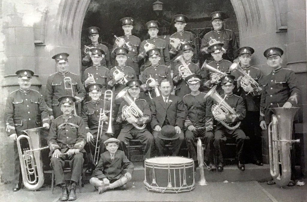
Copyright Anthony Page.
This photograph from Anthony Page’s collection shows the Blackheath Town Band at a somewhat later date, perhaps the 1930s. But their uniforms were probably the same and one or two of the members may even have played for Hospital Sundays!
There were traditional gathering places, too. Apparently the Hackett family who kept the George and Dragon had a field at the back (mentioned in the article above) where fairs and gatherings were held and the frontage of the George and Dragon remained a stopping place for processions until within living memory. I can picture the bands playing and puffing their way up Ross, leading the procession to Siviter’s Lane from the George and Dragon! And although a whole new housing estate was built in the area between the George and Dragon and Birmingham Road in the 1920s and 30s, this spot also was not very far from Britannia Park and the fields which were there before the park was laid out.
The only processions I can remember in the 1950s were the Whit Sunday Processions which were organised by the churches around Blackheath and ended up in Britannia Park, with games and sandwiches and cakes for tea (all in a brown paper bag for each child, if memory serves!) with orange squash or cups of tea for everyone. This spot would, of course, be just below the grounds of Mountford House and may even have been the very same field that was used then – a traditional gathering spot for celebrations!
More reading:
‘Who do you think you are?’ Magazine has an excellent article here:
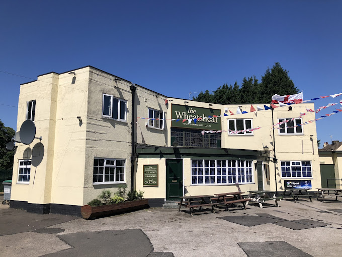
When, back in February 2023, I posted for the first time on the ‘I Remember Blackheath & Rowley Regis’ Facebook page about my then new One Place Study about the Lost Hamlets, I had some very encouraging responses, one of which was from Ronald Terence Woodhouse who told me that his family had been the original licensees of the Wheatsheaf and that his grandmother had lived in the first cottage going up Turner’s Hill, so right in the centre of the study area. And ever since, I have been meaning to do a piece on the Wheatsheaf. So here it is, at last.
Copyright: Mike Fenton. This shows the pub in about 1928 and the Water Tower on Turners Hill can be seen in the distance. This building was demolished soon after this and a replacement built.
The address shown in Hitchmough’s Guide [i] for the Wheatsheaf is 1, Turner’s Hill, or Darby’s Hill, Lye Cross, Four Lane’s End, Oakham, Rowley Regis. So quite which if those it is, I would not know. Probably all at one time or another. Perhaps part of the reason for this varying address is that these are all descriptions given in the different censuses, Lye Cross from 1841-1861, when the pub was managed by Benjamin Woodhouse from about 1834-1861, then by Joseph Cox from 1861-1892. Joseph Parkes was the Licensee from 1996-1904, Walter Woodall from 1911-1912, then it was managed by Howard Woodhouse in 1916 and then Thomas Woodhouse in 1919-1920. It is quite possible that the other licensees were related to the Woodhouses and Hitchmough does not have a complete list in terms of dates, but I have not looked at those families in detail at this stage.
In the 1871 Census, the pub’s address is shown as Turner’s Hill and in 1881 it is 35 Oakham, in 1901 it was 1, Turner’s Hill – Tavern – as in 1901. So this area seems to have been called various things. As late as 2022 the site was still described as 1 Turners Hill. But certainly there was a pub or tavern there at a very early date which continued until quite recently, only the Bull outlasting it.
The Wheatsheaf was situated at the junction of Portway Hill and the road which ran from Perry’s Lake up over Turner’s Hill. This area is not strictly part of the Lost Hamlets since it is not physically lost as the other hamlets have been, the area is still there although the pub has now closed. But there was a strong family spread across this area and the Turner’s Hill/Gadd’s Green/Perry’s Lake area with a lot of connections. Families from this area also often used the Dudley churches, rather than Rowley.
Benjamin Woodhouse Licensee 1834-1855)
In August 1826 and 27, August 1829 and again in August 1830 notices appeared in Aris’s Birmingham Gazette warning ‘Gentlemen’ against ‘sporting or trespassing’ on the land of various owners or they would be deemed ‘wilful trespassers. Signatories to this Notice included Benjamin and later Thomas Woodhouse, Benjamin Hadley and Thomas Smart, all names associated with Benjamin. There were similar notices relating to several other places, including Sedgley, Kings Norton and Sutton Coldfield although I do not know what gave rise to these nor whether they had any effect on the hunting /poaching and shooting parties. There was no police force as such in those days and people had to protect their land as best they could,in this instance by working together. However, it does show that at least Joseph Woodhouse was a well established landowner in this area by 1929 and the house may well have been operating as a beerhouse or pub by then but this is uncertain.
In November 1839, an auction was held at ‘the house of Benjamin Woodhouse at the Wheatsheaf’of a small freehold estate which was situated ‘at Portway’ within two miles of Dudley, by the side of the road leading to Oldbury, Titford and Birmingham, consisting of a Farm House, Barn, Cow-house, small tenement, and four closes of rich Pasture Land, containing about eight acres, ‘in the occupation of Thomas Woodhouse’. The notice emphasised that the property was in the immediate vicinity of numerous collieries and iron works, rendering it a ‘most desirable investment’. This may have been Portway Farm or another farm on that road.
Hitchmough lists the first licensee as Benjamin Woodhouse – from 1834-1861. In the 1841 Census Benjamin was there with his wife Sarah Woodhouse (nee Smart) and an Ann Woodhouse, aged 20, all born in Staffordshire. Benjamin and Sarah appear to have been married at Handsworth in 1812.
The 1841 Census does not give relationships but from what I have been able to research, it does not appear that Ann is the daughter of Benjamin and Sarah, I have only been able to discover one child born to them, Sarah Jane who was baptised at St Giles in 1832, when they had been married for twenty years and Sarah was forty four.
Sarah Woodhouse died in March 1854, aged 66 and Benjamin in early 1855, aged 69, both buried at St Giles. So clearly he cannot have been the licensee until 1861, as Hitchmough suggests. Perhaps the dates of 1861-1892 which Hitchmough suggests for the next licensee reflect the next licence record or possibly census that Hitchmough was able to find, there is sometimes a delay in finding records of licences changing hands.
Benjamin’s Will was made in October 1854, proved in May 1855 in which he describes himself as a publican of Lye Cross, so it seems that this was definitely the right Benjamin Woodhouse. In his Will, Benjamin leaves houses to the two sons of his niece Ann (so perhaps that was who was staying with him in 1841?) but most of his assets were left in a complex Trust for the benefit of his daughter Sarah Jane. The Trustees were his niece’s husband Enoch Hadley and Charles Cox of Oakham, both described as cattle dealers. Benjamin appears to have been quite well to do, leaving various properties and his Will leaves, amongst other things, his brewing equipment so, like many Victuallers at that time, he obviously made his own beer. But he also listed “furniture, brewing vessels, plate, linen, china, glass, books, prints, wines, liquors, consumable stores, and other household effects” amongst his possessions. Certainly it sounds like a well furnished and decorated house, I have not seen ‘prints’ listed in any other local Wills.
I began this piece fairly sure that I was not related to this family – there was not a Woodhouse to be found on my family tree with 7000 people on it. But then I found that Benjamin’s daughter Sarah Jane Woodhouse married a Major Rose – my mother’s maiden name was Rose. That started little bells ringing in my head as I have lots of Roses from Rowley on my tree. But Major Rose was from Halesowen, so not likely to be connected. It took me about ten minutes to find his father Aaron Rose, also living in Halesowen and a Gun Barrel Manufacturer – still no connection, no gun barrel makers amongst my lot. Then, in the 1851 census I saw that Aaron Rose was born in Rowley. Ah! And his parents were Moses Rose and Mary Stephenton, who were my 5xg-grandparents… okay, I am related, very distantly. Major Rose was my 1st cousin 5xremoved. I am beginning to wonder whether I am actually related to everyone living in the Lost Hamlets then…
Sarah Jane and Major had been married on 15 February 1854 at St Martins in Birmingham, where Sarah Jane was described as ‘of this parish’. This was only a few weeks before her mother died and I am slightly surprised that she was not married in Rowley. And her father’s Will went to great lengths to try to prevent her husband from benefitting from his estate, leaving most of his assets in Trust for Sarah’s benefit. Perhaps they did not approve of the marriage. Major’s family were involved in gun making and Benjamin Woodhouse would probably have been aware that Aaron Rose, Major’s father had been declared bankrupt in 1852. None the less, Sarah’s was a long and fruitful marriage, she and Major Rose had at least six children together, rejoicing in the names of Benjamin Woodhouse Rose (1855), Major General Rose, (1859), Sydney Herbert Rose (1861, Baron Rose (1864), Captain Rose (1866) and Sarah Jane Rose. The first two children were born in Rowley Regis (probably at the Wheatsheaf) but the later children were born in Halesowen where the family both farmed in the Frankley/Illey area and Major and his brothers continued to be much involved with gun barrel making.
On 18 April 1855, there is a notice in the Worcestershire Chronicle, stating that the transfer of the Licence for the Wheatsheaf had been sanctioned from Enoch Hadley (who was Executor for the estate of Benjamin Woodhouse) to Major Rose, Benjamin’s son-in-law.
Interestingly Hitchmough has a note that Hoof marks were reported on the roof of the Wheatsheaf in 1855!
And Major and Sarah Jane’s elder two children were born in Rowley in 1855 and 1859 so they may have stayed at the Wheatsheaf until then. In 1857 and 1858 Major Rose also took out Game Licences in Rowley Regis. But by the 1861 Census , Major and Sarah were back in Halesowen, he describing himself as an ‘ironmaster’ and certainly he remained involved with the family gun making business for many years to come. Also living with them in 1861, apparently as a servant, was Mary Smart, born Rowley Regis, aged 28. As Sarah’s mother was a Smart, I wonder whether she was actually related to Sarah.
The Woodhouses were numerous in Oakham and Lye Cross. There were three Woodhouse families on one page in the 1841 Census. I will do more work for a Woodhouse Family Study when time permits.
The other thing which is becoming clear from my research is that families who kept pubs tended to intermarry – their children were accustomed to the life, knew how things worked, and presumably met the children of other licensees socially. Looking at the marriages of the children of Thomas several of them and their children married into families – the Bate family, the Levett family, the Roses, the Woodhouses who were farmers , maltsters or farmers and especially publicans. Even when men marrying into the family were in other occupations, such as Joseph Cox who was a farmer, and Major Rose who was a gun barrel maker (although his father had been both a maltster and a licensee earlier in his life), these men turned their hands to becoming licensees when people were required to run the family pub. Keeping the businesses in the family!
Joseph Cox (licensee 1861-1892)
Ah, I thought – a completely different name, nothing to do with the Woodhouses then. It did take me half an hour of checking to discover that Joseph’s wife Sophia was a Woodhouse, the niece of the original Benjamin. So the Woodhouse family were still in control of the Wheatsheaf! I should not be surprised by now at how closely inter-related all the families in this area were.
In the Worcestershire Chronicle on 18th January 1860 there is a notice that a licence transfer had been permitted for the Barley Mow at Rowley from Joseph Cox to William Griffiths, presumably prior to Joseph taking over the Wheatsheaf. Hitchmough lists Joseph Cox as the licensee at the Barley Mow at Tividale from about 1855-1860, his time at the Barley Mow may have been sufficient to give him some experience in the licensed trade before taking over the Wheatsheaf.
In the 1861 Census, Joseph and Sophia were living at the Wheatsheaf with their children John, aged 6, Sarah Jane, aged 3 and Annie E aged 1, plus a house servant Sarah Rupp, aged 17 who was from Dudley.
In the 1871 Census, Joseph and Sophia were living at the Wheatsheaf with their children Eliza Ann, aged 18, John, aged 16 – a solicitor’s Clerk, Sarah Jane, aged 13, Ann Elizabeth aged 11, plus Mary Sophia, aged 9. (I don’t know where the eldest child Eliza Ann, then 8, was in the 1861 Census, as she is not listed with the rest of the family at the Wheatsheaf and I can’t immediately find her with other relatives in the area.)
There was an inquest held at the Wheatsheaf in October 1878 and details of this appeared in the Birmingham Daily Post on the 18th October:
Birmingham Daily Post 18/10/1878
“Yesterday afternoon Mr. Edwin Hooper, coroner, held an inquest at the WHEAT SHEAF INN, Turners Hill, on the body of Joseph Woodhouse (53), a milkseller, who died under circumstances already reported.
Mrs. Woodhouse said she had been delivering milk with her husband on Monday night, and when in Gipsy Lane, on the road home, she heard a great shouting, and saw a trap loaded with men behind them. Her husband pulled more on one side, but as he did so the horse became frightened, and bolted with them. She lost consciousness, and when she recovered her husband was lying by the road side insensible. She had fallen on her shoulder, and her collar bone was broken. At the time she recovered the men in the trap were driving off faster than ever. A young man helped witness home, and brought her husband. The men were to blame for shouting so loudly and frightening the pony.
Joseph Harvey, of Tividale, said he heard five or six men in a trap driving at full speed, and shouting to Woodhouse as though they wished him to get out of the way. When the pony bolted both were thrown out, and the trap fell over. He called to the men, but they would not stop.
Police-constable Gevin said he had made full enquiries as to the men in the trap, but had not learned who they were. He received no information of the man’s death until late on Tuesday evening.
The Coroner summed up, and asked the jury if they would have an adjournment to give the police more time. There seemed no doubt but that the men would say if brought before the jury that they were simply shouting for the old man to get out of the way. The wife evidently did not seem to think much of the blame to be attached to the men, for she made no complaint, and did not inform the police of the death of her husband for a long time.
The jury then returned a verdict of Accidental Death.”
So this, although not directly related to the Wheatsheaf, was related to the Woodhouse family, one time and perhaps continuing owners of the Wheatsheaf who continued to farm throughout this period in the immediate area of Oakham/Lye Cross.
In the 1881 Census, Joseph and Sophia are still at the Wheatsheaf with son John, now a Clerk at the Colliery, rather than a Solicitor’s Clerk, and daughters Annie and Mary.
In 1891, listed as 1 Turner’s Hill, Joseph is still listed as a licensed victualler and Sophia, Annie and Mary are still living at home and unmarried.
Sophia Cox died in 1894 and Joseph Cox re-married and retired to Smethwick with his new wife where he died in 1903.
Joseph Parkes (licensee 1896-1907)
In 1901, The Licensee is Joseph Parkes, aged 60 and his wife Sarah Jane Parkes.
So far was I know, there is no connection between this couple and the earlier licensees. Parkes is such a common local name that I have not been able to narrow down any more information. So it may be that this was the point at which the family sold the pub to Thomas Williams of the Rowley Brewery. Or it may be, of course, that Joseph Parkes or his wife may have been related to the Woodhouse/Smart/Cox families and I have simply not yet found the link! As Sarah Jane is a name much used by the Woodhouse and Cox families, it was tempting to consider whether Joseph had married into those families but it appears more likely that he was the Joseph Parkes who married Sarah Jane Adams in 1862 in Quinton.
During Joseph’s tenure as licensee, Hitchmough reports an amazing procession, starting at the Wheatsheaf in 1898.
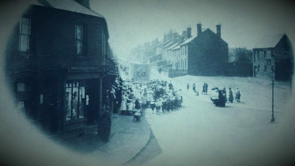
“County Advertiser 24/9/1898
“On Sunday afternoon the annual friendly societies’ Sunday service, on behalf of the hospitals, was held in a field at the back of Mountford House, Siviters Lane, Rowley, kindly lent for the occasion by Dr. J. G. Beasley. The members of various societies met at their headquarters, and were formed into a procession as below. The Blackheath Village Band started from the WHEAT SHEAF INN, Turners Hill at one o’clock, with the Church of England Friendly Society, and proceeded through Portway and Perrys Lake, calling at the BULLS HEAD INN for the Sick Club, at the WARD ARMS INN for Court Foresters’ Pride, at the KINGS ARMS INN for Lodge Working Man’s Friend. It then proceeded by way of Ross, Holly Road, Tump Road, and John Street, to the GEORGE AND DRAGON Ground. The Woodgate Brass Band had in the meantime covered its route from the OLD BUSH INN, Powke Lane, with Court Little Band of Hope, calling at the MALT SHOVEL INN for Lodge Lily of the Valley, the VINE INN for Court Mistletoe Bough, proceeding along Station Road to the RAILWAY INN for Court Britannia’s Pride, thence through Halesowen Street, Tump Road, and Hackett Street, meeting the other Courts at the GEORGE AND DRAGON Ground. A united procession was then formed, and marched to Siviters Lane, reaching the ground at three o’clock. The proceedings opened with the hymn ‘All people that on earth do dwell,’ after which the Chairman (Mr. E. Pewtress, CC) delivered a short address.
The Rev. C. W. Barnard, MA, Rector of Kings Norton, then addressed the meeting, after which the hymn ‘Lead, kindly light,’ was sung. Addresses were also delivered by the Revs. W. Hall and N. Haigh, of Blackheath.
At the close a collection was taken on behalf of the Dudley Dispensary and Birmingham Eye Hospital. It amounted to £11 9s 5d.”
What an amazing event that must have been to see, I can imagine the local children dancing happily alongside the procession. It is clear from this that many of the local pubs, including the Wheatsheaf, ran friendly societies to assist people with illness and medical expenses, in those days when there was no health service, no national insurance and when fees had to be paid for a doctor to visit.
Walter Woodall 1907-1912
In 1911 Walter Woodall (35) was listed as ‘brewer [beer], licensed victualler’ and both he and his wife Elizabeth were born in Wednesbury and, again, there is no obvious connection to the previous owners. The elder two of their children Florence (11) and Walter (5) had been born in Tipton but the youngest Harold (1) was born in Rowley.
Walter Woodall appears only to have been there for five years and the only mention of him in the Press is for the transfer of the licence for the Wheatsheaf from him to Thomas Henry Holland in 1912. Which is rather odd because the same report also notes the transfer of the licence of the Barley Mow in City Road, Oakham to the same Thomas Henry Holland! And Hitchmough does list Holland as the licensee at the Barley Mow from 1911 -1916 but does not mention Holland in relation to the Wheatsheaf. Perhaps a reporter error, as Hitchmough lists the new licensee for the Wheatsheaf in 1912 as Howard Woodhouse, succeeded in 1919-1920 by Thomas Woodhouse. Yes, the Woodhouses, after a gap of more than 50 years (or perhaps 20 if you take into account the Cox family who were also close Woodhouse connections).
Purchase of the Wheatsheaf by Thomas Williams of the Rowley Brewery
Despite all my efforts to associate later licensees with the Woodhouse family, it may well be that in fact the pub was sold in 1896 when the Cox family retired and it is simply coincidence that Woodhouses were back in 1916. Hitchmough notes that the owner of the Wheatsheaf was T B Williams (who had taken over the Bull in about 1875 and who died in 1908) and the Rowley Brewery, followed by Thomas W Williams and Lizzie Bate, before being sold to Ansells in 1946 and subsequently Admiral Taverns. I had noted in my piece on the Bull [ii] that T Williams, the owner there had expanded his brewing and pub-keeping activities from when he took over as licensee of the Bull and had bought both the Wheatsheaf at Turners Hill and the Grange in Rowley Village. So it appears that although the Woodhouses were licensees in 1916, they no longer owned the pub.
Thereafter, Hitchmough listed thesucceeding licensees as :
Howard Woodhouse 1916
Thomas Woodhouse1919-1920
Edward Harrison (1920-1929)
Frank Green (1929)
Frank Jinks (1929-1957)
Walter Raymond Harris (1957 – 1960);
Frederick William Hughes (1960 – [1965]
Frederick Brown (1968 – [ ]
C Swarbrick (1970 – [ ]
Arthur Isherwood (1981 – [ ]
Glenn Whitehouse [1988]
Sara Harvey (2015 – [ ]
Twentieth century genealogical records are much sparser than earlier ones and I have no further information about these licensees although many Rowley people will have memories of more recent ones, as customers at the pub! The licensees in 1988, Mr & Mrs Whitehouse, complained that when the road over from Perry’s Lake over Turners Hill was closed, they lost a substantial amount of trade from Rowley Regis.
Copyright unknown. Taken in 2018, this shows the replacement pub, looking prosperous and well maintained.
The original pub was demolished in about 1930 and a replacement built behind it. This closed permanently in 2019, like so many pubs, still described as 1 Turner’s Hill and planning permission was sought in 2022 to redevelop the site with a very modern block of flats. However I note, from the Sandwell Planning website, that the Council Officers considered that this site was an adopted open space within the Strategic Open Space & a Wildlife corridor, no decision notice or withdrawal of the application is listed and there appears to be no further progress on this application since then.
So far as I am aware, the pub building remains boarded up on site at present, another previously well used pub which has now gone.
I have been working recently on another family study for my blog, this time about the Hill family, one of the core families who lived in the hamlets for centuries, mainly at Finger-i’the-hole and Gadd’s Green. As usual, it has proved more complex than I had anticipated and I have got sidetracked into considering where exactly the branch of the family I am looking at lived in the village. Many of them, it appears, lived for centuries in a group of houses in Finger-i’the-hole or Fingeryhole , or Gadd’s Green.
Regular readers may recall that I have posted previously in this blog about the whereabouts in Rowley village of Finger-i’the-hole or Fingeryhole[i].
And, in a separate post [ii] I wrote last year about a newspaper article I had found, in the Dudley Chronicle in 1925, about the delights of what the writer called Portway but which clearly included the wider area of Perry’s Lake and Gadd’s Green. The article referred to the dilapidated cottage in Gadd’s Green as “Finger o’the hole cottage” which the author had visited in 1925, a cottage where the front wall had collapsed in a storm some time before and never been rebuilt.
As a reminder, and for new readers, the name Finger-i’the-hole originates from a very old local story – but which was subject to several variations in later years. A lonely old widow, the story goes, lived alone in a small cottage on Turner’s Hill. A thief or rent collector, depending on which version of the story you look at, knowing that she was unprotected, put his finger into the hole in the door to lift the latch, with a view to robbing her- or perhaps collecting the rent! – only to discover that the feisty widow, hearing his approach, had picked up her axe and chopped off the offending digit as it was poked through the hole. Though there are no names attached to this tale, there is a locality and I believe that it is likely that some incident of this sort actually happened.
The date of this event is unclear but must have been before 1727, as Christopher Chambers of “Ye ffinger I’the hole” was buried then, according to the Parish Burial Register. And the name of Finger-i’the-hole for the area persisted until the 1841 Census but had dropped from official use by 1851 when the area , with exactly the same families, was called Gadds Green.
The Chambers family appear, although I have not done any detailed research on them, to have been well-to-do, they appear in the Parish Registers as living also in 1724 at ‘the Brickhouse’ and in 1723 and in 1744 as ‘of Freebodies’ so were perhaps brothers as tenant or yeoman farmers. At that time ‘the Brickhouse’ appears to have been at Cock Green, with land extending down towards Powke Lane which later was developed in the 20th century as the Brickhouse housing estate. Brick was not a commonly used building material at this earlier date and the use of bricks for a whole house was obviously distinctive and worthy of a special name.
Photograph copyright: Glenys Sykes
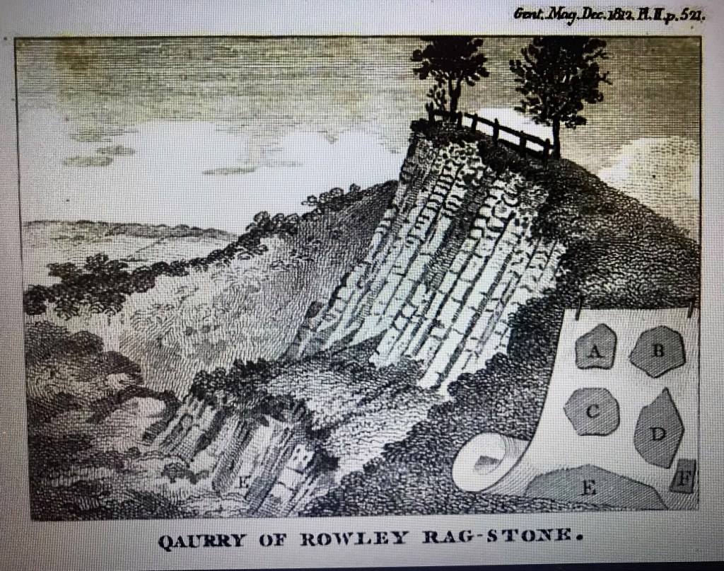
This is an illustration shown in Wilson Jones’s book of what the barn of the ‘Brickhouse’ farmhouse might have looked like. Note the ragstone wall and what appear to be large chunks of ragstone lying around. I took a photograph recently of the pieces of ragstone still in Tippity Green/Perry’s Lake, at the entrance to the former Hailstone quarry, they have a familiar rugged shape.
Ragstone blocks at Tippity Green November 2024, photograph taken at the entrance to the former Hailstone Quarry. Copyright Glenys Sykes.
There were lots of the Chambers family in the village throughout the parish registers. An entry in 1723 refers to a Thomas Chambers of Portway and in 1732 an Edward Chambers of Tividale so they did seem to live at this end of Rowley. There was an Edward Chambers at Freebodies Farm in the 1841 Census, albeit described as a farm servant but there were no Chambers that I can find listed in the later censuses in the Lost Hamlets and it appears that they dispersed around a wider area, including Oldbury and Birmingham.
Picturesque Portway
In the newspaper article on Old Portway, which had been written in 1926, I remembered a comment in that article about the cottages at Finger-i’the-hole and this is what it said:
“Our representative visited the now dilapidated cottage where the incident is reputed to have taken place. The cottage is the fourth of a row, and is known in the neighbourhood as “Finger ‘o the hole cottage. “, The article continues “The front of the building was blown out one winter’s night many years ago when the occupant was a Mrs Cox, now of Gornal, and it has never since been repaired. The cottage is said to be over 300 years old and one family – that of Hill, members of which reside in an adjacent cottage – lived there for nearly 200 years.
It is constructed of rough grey sandstone, and originally had two rooms, one up and one down. A stout roughly hewn oak beam, crossing the building from gable to gable, indicates where the first floor once rested, and shows that the height of the living room was under six feet. Occupying one-half of the building is a spacious old-fashioned fire-place, with a large open chimney and contiguous bake ovens.”
This description of the house known as “Finger ‘o the hole cottage. ” is very interesting.
“The cottage is the fourth of a row.” So it could originally have been the end of a much older hall house.
“The cottage is said to be over 300 years old” – which takes it back to about 1600 or even earlier.
“It is constructed of rough grey sandstone.” Would this have been Rowley Rag? Something substantial to last more than 300 years, unlikely to have been simple wattle and daub.
“A stout roughly hewn oak beam, crossing the building from gable to gable, indicates where the first floor once rested and shows that the height of the living room was under six feet.” Was this beam a later addition to divide the hall and add extra accommodation?
“one-half of the building is a spacious old-fashioned fire-place, with a large open chimney and contiguous bake ovens”. I can remember when I first read that description, something jarred with me. The original article goes on “No fewer than ten men can comfortably stand in the aperture once occupied by the grate and its side seats.”
A humble cottage in a terrace does not have half of the single living space taken up by a fireplace big enough for ten men to stand inside it and nor does it have ‘contiguous bake ovens’, it was unusual for small cottages to have even one oven, certainly not two. There may have been an external bakehouse or oven for a farmhouse or larger dwelling and with large fireplaces in bigger buildings an oven was sometimes built into it. There is an interesting piece with a brief history of baking here – https://www.historyextra.com/period/medieval/a-brief-history-of-baking/
So something is out of the ordinary here. Perhaps there are more clues in the rest of the description of the cottage.
“it originally had two rooms, one up and one down.”
Was this a Hall house? Hall houses had one great room which might well have had a great fireplace installed at some stage – I knew that originally such halls had a central hearth and the smoke floated up into the roof. Later fireplaces and chimney breasts were added. But why the need for such a big one?
But if it was a hall house occupied by a large family or was a busy farmhouse with farmhands to feed, two ovens might well have been provided.
And at a time after the original construction the hall might have been divided into more rooms or cottages and even divided into an upper and lower floor, although if it had been designed to have two floors surely the ground floor would have been higher than six feet when it was first built?
Hall houses
So I began to suspect that this may well have been a very old hall house, perhaps the home of a farming family but that later it was divided and subdivided. And that the Hill family lived there for centuries.
I decided to research a little more about ‘Hall houses’, to see whether my thoughts seemed reasonable. This information is taken from Wikipedia:
“The hall house is a type of vernacular house traditional in many parts of England.
Origins
In Old English, a “hall” is simply a large room enclosed by a roof and walls, and in Anglo-Saxon England simple one-room buildings, with a single hearth in the middle of the floor for cooking and warmth, were the usual residence of a lord of the manor and his retainers. The whole community was used to eating and sleeping in the hall. Over several centuries the hall developed into a building which provided more than one room, giving some privacy to its more important residents.
By about 1400, in lowland Britain, with changes in settlement patterns and agriculture, people were thinking of houses as permanent structures rather than temporary shelter. According to the locality, they built stone or timber-framed houses with wattle and daub or clay infill. The designs were copied by their neighbours and descendants in the tradition of vernacular architecture. [a] They were sturdy and some have survived over five hundred years. Hall houses built after 1570 are rare.”
When considering this house I was slightly concerned that I cannot find any mention in other records of a substantial house at Gadd’s Green, although Wilson Jones in his book[iii] lists all the other significant manors or large houses.
However, David Hay, in his book The Grass Roots of English History[iv], says that although it was once believed that all timber framed houses had been built by the wealthier inhabitants of local societies and that medieval peasant houses were so insubstantial that they could not survive for more than a generation, more recent systematic recording of houses by members of the Vernacular Architecture Group and the new technological advances in dendrochronology, have overturned these views and it is now known that of the thousands of medieval houses, some of which are still standing in many parts of rural England [though not in the Lost Hamlets!] belonged to ordinary farming families. Hey states that “The sheer numbers of cruck [timber framed] houses in the Midlands confirms that they must be peasant dwellings, some villages have ten or even twenty such houses.” So it seems quite possible that there would well have been such a house in Gadds Green inhabited by a farming or working family, rather than a more aristocratic one.
Cruck framed houses
Many larger houses at this time were ‘cruck-framed’, that is the central frame, the load bearing members that supported the weight of the roof of the building was made from suitable trees – often oak, which carpenters could split lengthways into two identical ‘blades’ which were set either side of the building and then joined at the top with techniques varying from place to place to support a ridge-piece, the crucks sometimes resting on stone bases to protect them from damp and rot. Half way down the roof, between the ridge-piece and the wall plate other long timbers, known as purlins, were fixed to the outer part of the blades in order to carry the rafters which supported the roofing material, often thatch in earlier times. Because the crucks, and not the walls carried the weight of the roof, the walls could be filled in with whatever material was most easily available to them locally. This could easily be replaced in later centuries without endangering the roof.
The frames were constructed in the carpenter’s workshop or in the wood where the trees were felled before they were assembled at the site according to the sequence of the marks the carpenter had made with his chisel or gouge. Different types of marks can still be seen on timbers in old buildings and it appears that each carpenter had their own marks and systems; some buildings had several hundred pieces of timber and hundreds of joints so carpenters needed a way of sorting these efficiently when they arrived at the construction site. This construction method was a skilled job and not to be undertaken by home builders!
Copyright Wikipedia. This is a cruck house in Worcestershire where the cruck frame can be clearly seen, along with other timbering, in this case infilled with what is probably wattle and daub. In Rowley, with the abundance of local stone, the walls would have been infilled with stone and quite possibly the timbers clad with stone to protect them from the weather so that the cruck frame would not be obvious from the outside.
If the house at Gadd’s Green was constructed in this way, with a cruck frame, this might account for why the front wall of one section could be blown or fall down in a storm but the remainder of the structure remain apparently quite stable for many years afterwards, as mentioned in the article, especially if the inhabitants did not have the skills required to make the repairs.
Peasant Houses
Note: Hey suggests that “peasant” is still a convenient term to describe a small-scale farmer, the type of person who would have been the head of household in most of the surviving timber frames houses. I have continued his usage so this is not intended as a derogatory term. There is an interesting article on this here: https://archaeology.co.uk/articles/peasant-houses-in-midland-england.htm
Houses were typically arranged around a central hall that was open to the rafters. These halls could be lengthened by the addition of an extra bay or two but their almost standard width was regulated by the roof span. A wood fire in a central hearth originally provided the heating, with most of the smoke escaping through the roof but timber and plaster smokehoods attached to an internal wall were starting to replace central hearths in the wealthier districts. Sometimes later refinements, ceilings, floors, partitions, etc completely conceal this original use and it is only when the smoke darkened timbers are seen in the attic at a much later date that it is realised that the building started life as a hall house.
The lower end of the building may have housed a workshop or a kitchen, dairy or buttery. And a very large fireplace in a cottage at Gadd’s Green may have been a remnant of this earlier use.
“At the other side of the hall, larger peasant houses had a private parlour, sometimes with an upstairs room known as a solar.” Is this what the family memory of the Hills referred to when they talked about the house originally having one room downstairs and one upstairs?
Poor families had to build with whatever materials were to hand, such as clay and wattles for wall panels or earth for mud walls, as in Devon, probably ragstone in Rowley. The many timbered buildings surviving in small towns in Herefordshire, Hey notes as an example, were in well-wooded areas and where woods were managed to produce suitable crops of timber over a long period. And in poor areas, solid houses would not have been readily replaced with more modern structures. So if a substantial house had been built which lasted for centuries at Gadd’s Green, why would the family expend money to replace it? Some of the Hill family later were nail factors or nail ironmongers and relatively well-to-do but others showed no sign of great wealth.
House layouts
In Midland villages, Hey suggests, “each house was separate and protected from unwelcome intrusions. The whole property, including a garden or yard, was surrounded by a fence, hedge or wall, and accessed through a gate leading on to the street and a door with a lock, (finger hole?). Excavations on village sites show that barns, stables, cowsheds and other outbuildings usually stood close together around a yard, kitchens and bakehouses were often detached, to reduce the risk of fire”.
In the view of Hey and other scholars, “the idea of separate living and working spaces would probably not have seemed a meaningful concept to member of a peasant household. There is plenty of documentary evidence for the conversion of bakehouses, carthouses and stables into dwellings for retired peasants”, indeed barn conversions and such continue to this day!
Why and where?
There were many cruck buildings in some parts of the country and none in others for reasons not fully understood. It is possible that the native pendiculate oak trees, whose shape is ideal for cruck construction, predominate in areas such as parts of Yorkshire, Lancashire and Cheshire, along the river Severn in parts of Wales and in other Midland Counties. In eastern England, where cruck framing is conspicuously absent, the less suitable sessile oaks are the major type.
Hey notes that the medieval houses of Midland England are predominantly cruck framed and three bays in length. The chief limitations of cruck framed buildings are in their height and width, because their dimensions were dependent on the size of the blades that could be cut from suitable local trees.
“When it became fashionable to insert a ceiling into a hall that had previously been open to the rafters, the space in the upper storey was very constricted “- or perhaps sometimes the lower storey which might account for the low ceiling mentioned in the 1925 article.
This restriction did not apply to the other main construction method which was where posts and beams were made to create a box like frame and where the roof was supported throughout the frame and the walls. It is possible to find both methods of construction in one house, perhaps with a cruck framed hall having additional wings built with box frames.
These are other things that Wikipedia has to say about hall houses.
“The vast majority of those hall houses which have survived changed significantly over the centuries. In almost all cases the open hearth of the hall house was abandoned during the early modern period and a chimney built which reached from the new hearth to above the roof.
Fireplaces and chimney stacks could be fitted into existing buildings against the passage, or against the side walls or even at the upper end of the hall.
Once the clearance within the hall was no longer needed for smoke from the central hearth, the hall itself would often be divided, with a floor being inserted which connected all the upper rooms.
In smaller hall houses, where heat efficiency and cooking were the prime concern, fireplaces became the principal source of heat earlier.
In the earliest houses combustion of wood was helped by increasing the airflow by placing the logs on iron firedogs. In smaller houses the fire was used for cooking. Andirons provided a rack for spit roasting, and trivets for pots. Later an iron or stone fireback reflected the heat forward and controlled the unwelcome side draughts. Unsurprisingly the hearth migrated to a central wall and became enclosed at the sides.”
So it does seem to me that all of these points, both from Wiki and Hey, tie in with my theory of the house at Gadds Green having been, at one time, one large dwelling, later subdivided into two storeys and into separate cottages.
On the ground
We cannot look at the house or the site now, it has literally been obliterated.
There are no detailed maps before the mid-1800s.
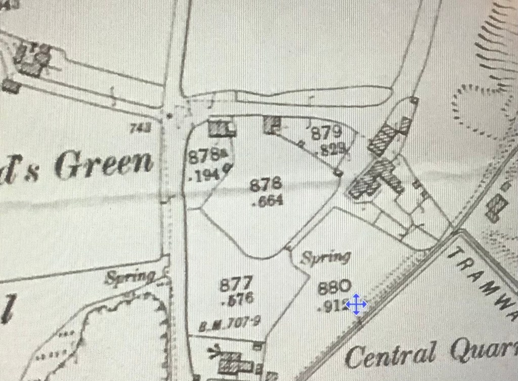
Photograph copyright Glenys Sykes, apologies for the poor quality. Map Copyright: https://maps.nls.uk/
Maps of the area on the NLS website include this OS Map, at six inches to the mile, which was apparently surveyed in 1881-83 and published in 1887. This shows a row of dwellings at Gadd’s Green, with what may have been a yard or fold at the North end.
Incidentally this map also shows a stretch of water at Perry’s Lake which presumably gave this area its name. I have seen suggestions that this may originally been a fish pond for the Manor farm at Cock Green.
This second map is at 25” to the mile, was originally surveyed in 1881, revised in 1937 and published in 1947. This shows a row of four dwellings and a further one at the rear, plus an additional block of buildings. But the shape of the site including the fold or yard remains. There are also springs marked just along a lane which would have provided the essential water supply for a farmhouse. On both maps, this is the last building in Gadd’s Green before the road continues up Turner’s Hill, and that is where the home of the Hill family always appears in censuses.
There is no sign of water at Perry’s Lake on this later map. Although there is a mysterious building halfway between Perry’s Lake and Gadd’s Green which I suspect may be the Methodist chapel which appears in various records but later disappears. It appears to be a square building with an entrance porch at one corner and a small room at the back, perhaps a vestry or schoolroom.
And farm houses in the area do appear to have survived better than most other buildings in the Rowley area. They were probably bigger to accommodate some farm workers as well as family and it is also possible that an undercroft or part of the building could also have been used to shelter animals. There may also have been buttery or cheese stores, as well as outbuildings, barns for the storage of crops, stables for horses and vehicles and tools, plus workshops on the site any of which may have been incorporated into the farmhouse in later years.
A Will I have recently been transcribing relates to a farmer who was related to the Hills and who owned farms in Hagley and Belbroughton. The description of the Hagley Farm reads: “my Capital Messuage or dwelling house wherein I now reside with the Brewhouse, stable, Coachhouse, cowhouse and other outbuildings, Courtyard ,fold yard, Garden Ground and orchard thereunto adjoining and belonging (comprising all the buildings and the Courtyards Garden rounds Orchard and premises adjoining together on that side of the road.
Which illustrates the number of additional buildings and grounds a substantial farm might have. But even a smaller farm, like the one in Rowley village described in the Will of Ambrose Crowley, had outbuildings of a barn, workshop and yard. Thinking about this, it is clear from even later maps that the Grange site and the Portway Tavern site at Perry’s Lake were arranged in a very similar way and may also have been on an older sites and originally used as a farm.
Old Buildings in Rowley
There has been an interesting discussion this week on the “I remember Blackheath and Rowley Regis” Facebook page, after I asked where the oldest buildings in Rowley were now. The answer appears to be – several pubs, more than one farmhouse, a few well built cottages still survive. It would be fascinating to see the rafters in the roof of some of these houses to see whether any of them were cruck buildings and whether they were once blackened by the smoke from a central hearth!
So the long gone ancestral home of the Hill family in the Lost Hamlets is the rabbit hole I have been exploring for the past few days. Perhaps, – although I shall never know for sure since the house is one of those which disappeared when the quarry expanded – possibly a Hall house, probably a farm house, later four cottages – including the famous Fingeryhole cottage – which I think I have identified on the map. A fascinating – for me, anyway – glimpse of how the local families lived in centuries gone by, and how local legends may have an element of truth and a thread reaching back through the centuries.
On the 19th August 1926, nearly 100 years ago, the Dudley Chronicle published an article which it entitled “Picturesque Portway – Interesting Facts about a Little Known Village”. I have not often seen Portway described as a village but no matter. And there seems to be some confusion in the mind of the writer as to where Portway village was, as the Portway Tavern is mentioned as being in the village. And cottages in Gadds Green are also mentioned in the article so Portway seems to be a very broad description covering several of the lost hamlets, rather than the area we know as Portway now. The writer clearly does not regard the area which I think of as the Lost Hamlets as part of Rowley village but rather as an insular self-contained community in itself. But there are indeed some interesting facts mentioned. And I am including it in the study of the Lost Hamlets because parts of the article refer to them.
Portway was introduced in the article as “a small ancient village on the slopes of the Rowley Hills, its associations stretching down into the very roots of our early history”.
The year this was written – 1926 – is significant because this was time of the General Strike, which lasted from 3rd to the 12th May. Much of the impetus for the strike related to the mining industry where the mines were in the ownership of private individuals and where working and safety conditions were poor and wages had been steadily reduced over a period of a seven year period was reduced from £6.00 to a miserly £3.90, an unsustainable figure contributing to severe poverty for a generation of workers and their families. When the mine owners announced their intentions in 1926 to reduce wages further and to increase working hours, they were met with fury by the Miners Federation. “Not a penny off the pay, not a minute on the day” was the response of the miners. Although the General Strike was only for a few days, the dispute between miners and mine owners lasted in some areas until November of that year.
Copyright: Anthony Page
One of the results of that, and not for the first time, was that people went out digging bits of coal from waste heaps around the mines, as shown on this photograph from Anthony Page’s first book on Blackheath, though he dated this photograph to 1912. But pits were already closing before that, according to Chitham, due to being worked out or because they were flooded, owing to the various owners being unable to agree on a comprehensive drainage scheme. During the 1926 General Strike, no coal was being produced which meant that the mine pumping engines had no coal and water rose in all the mines, sometimes to the top of the shafts. Coal picking on pit mounds became commonplace and Chitham says that miners assembled in hundreds to protest and support the pickers for the pit banks were also being explored by the mine owners, attempting to supply customers – removing waste coal, slack and other material was illegal for the public. But the damage was done to the mines, most of the pits never recovered.
So it was this background which led the article in the Dudley Chronicle to describe Portway as “a miniature Eldorado for coal-pickers since the commencement of the coal strike”. The result of the activities of the coal pickers was that “moss capped pit mounds, derelict these many years, to which Time has brought some appreciable improvement in aspect and old pathways, leading over sites of collieries long forgotten – few wanted to remember them – have been dug up and are now honeycombed with potholes and chasms.” There was a specific example mentioned of a well used path which led from Whiteheath Villa into Throne Road and which was said to be now full of holes, some five feet deep and several yards in circumference, which the writer feared might prove very dangerous on dark nights if they remained unfilled!
Although the writer did not claim that the area was all beautiful – “Portway’s greatest admirer would not call the village beautiful” – he considered that centuries before the area must have been “replete with aesthetic scenery” and must have commanded “one of the most charming panoramas in South Staffordshire”, which he considered had not been destroyed by industry. “There are many more natural altitudes in the county but none of the scenes visible from them is more beautiful today than that part of Worcestershire which, when visibility is good, can be seen from the apex of Portway’s heights, beyond the smoke and dust of the intermediate industrial parts”. A touch of the Hackney Marshes in that observation, methinks.
The situation, the writer continues, was different now in 1926. The many derelict pit mounds, of gigantic proportions, had been beginning to assume a vernal aspect and might have been, in a few years, as verdant as the Rowley Hills themselves, but were now as much of an eyesore as ever they were. “Just when people were beginning to comment upon the phenomenal aptitude of plants and herbage to grow and flourish on derelict land, the all life-giving powers of nature were frustrated by a few weeks of economic distress”. Perhaps not quite how the miners and their families would have seen it!
However, the article goes on to say that Portway would remain attractive because the fascination of the ‘obscure little village’ was attributable to “its old-world atmosphere, its divers associations with the past and old and interesting legends which had been handed down through the generations and will doubtless survive more incredulous generations than our own”.
Here are some of the things the writer found of interest in 1926.
The legend of the Finger i’ the hole cottage
This is a story much discussed on the Facebook page “I remember Blackheath and Rowley Regis” with several variations on a theme. So here is the story which was being told by local people in 1926.
“One of the strangest of the legends is that of the Scotsman, who, when collecting money from the cottages in Gadds Green, Portway, went to a cottage, put his finger in the hole provided to lift the latch, and had it chopped off by the occupant.
Our representative visited the now dilapidated cottage where the incident is reputed to have taken place. The cottage is the fourth of a row, and is known in the neighbourhood as “Finger ‘o the hole cottage. “
Copyright: Alan Godfrey Maps
Here is the 1902 OS map of Gadd’s Green and there are indeed four cottages in a row – could this be the location of the legendary Finger i’ the Hole Cottage?
The article continues “The front of the building was blown out one winter’s night many years ago when the occupant was a Mrs Cox, now of Gornal, and it has never since been repaired. The cottage is said to be over 300 years old and one family – that of Hill, members of which reside in an adjacent cottage – lived there for nearly 200 years. It is constructed of rough grey sandstone, and originally had two rooms, one up and one down. A stout roughly hewn oak beam, crossing the building from gable to gable, indicates where the first floor once rested, and shows that the height of the living room was under six feet. Occupying one-half of the building is a spacious old-fashioned fire-place, with a large open chimney and contiguous bake ovens. No fewer than ten men can comfortably stand in the aperture once occupied by the grate and its side seats.”
What a picture that paints! The Hill family were certainly in the area of the hamlets, two families of them in Gadd’s Green, then called Finger i’ the hole, in the 1841 Census and in later censuses also in Perry’s Lake.
A Royal Visit
“Another well known legend about the locality” the article goes on “is that concerning King John. It is said that in the early part of his reign the King visited the neighbourhood, and set up his throne in Throne Road. The site is supposedly marked by a group of four old cottages at the bottom of the road, and the story was once printed and sold by an enterprising grocer in the district. Verisimilitude is given to this otherwise almost incredible story by the fact that King John was greatly interested in Worcester, in the adjacent county (where he was buried) and was a frequent visitor to that place. He also frequently hunted in the forests of Kinver and Feckenham, which are not far distant from Portway.
The legend associated with Romsley in Halesowen, is that King John came onto Romsley Hill and, seeing the Premonstratensian monastery [presumably Halesowen Abbey] from that altitude, a circumstance he had wished to avert, walked away in disgust, also tends to give credibility to the Throne Road episode.”
What interests me about this account is that, although I had never heard about the Romsley story, my mother told me that she had been told as a child that Bell End was so called because King John had a Hunting Lodge there where a bell was rung to guide the hunters back after the chase. So that is another story which associates the Rowley area specifically with King John. I have also wondered how the area which always seemed to be known as ‘The Throne’, long before it became Throne Road, got such a name. So perhaps it just may be true. And I have not seen any convincing account of how the area came to be Rowley Regis, Rowley of the King. Maybe, maybe…
Roman Portway
The article also tells of possible associations of the area with the Romans. The name Portway itself is, the writer claims, indicative of a Roman Road over the heath, or perhaps the old line of British trackway. I have heard it suggested that it may have been one of the ‘white ways’, the roads along which salt was transported around the country. These roads often passed through places with the word white included in their name, presumably because the salt was white. And it may or may not be coincidence that our portway road passes through Whiteheath…
Another Roman connection mentioned in the article relates to the discovery in 1794, when some workmen were demolishing a wall in the locality and discovered an ancient pot or vase which contained a large number of Roman silver coins. The article states these two indications go “conclusively to show that Romans once occupied the neighbourhood, which was in those days of considerable strategical importance, owing to its altitude”.
I must admit, I am not quite as convinced as the writer obviously was but it would be nice to know where those Roman coins went to!
Portway Houses
A peculiar characteristic of a number of old cottages in Portway was noticeable, apparently, which was that one or perhaps more of the windows in each were bricked up, undoubtedly by former tenants (or landlords) to evade the window tax. As an alternative to paying tax, the article suggested that “our forebears could live solitary lives in darkened tenements”.
The window tax was in force from 1695 to 1851 and led to many windows or openings being closed up to avoid the tax. a tax of two shillings was set for all homes with up to ten windows, with four more shillings payable by those with up to twenty windows and a further four shillings on top of that by those with more than thirty. The tariffs were varied over time. In 1766 the primary threshold was adjusted to seven windows. Unsurprisingly, the number of homes with exactly seven windows swiftly plummeted by an estimated two thirds. This legislation apparently gave rise to the expression ‘daylight robbery’.
An article online suggests that “the health of the population was significantly affected by the inevitable tax planning manoeuvres of the day. Even by the mid 18th century the medical profession were clear that living without adequate light and ventilation was causing increased typhus, smallpox and cholera and this is borne out by the Public Health Reports I wrote about recently. The tax, and property owners’ attempts to avoid it, had become a primary cause of death for many of the country’s poor”.
One can, of course, still sometimes see houses where windows have been bricked up for this purpose but generally only in fairly substantial houses though this may only be because the poorer dwellings have long since fallen down or been demolished.
Also on local houses, the writer observed that there were a large number of houses in Throne Road which were of some antiquity.
Old Portway Farm, 1960s. Copyright unknown but will be gladly acknowledged on receipt of information.
Several apparently had doors “on the outside of which was quaint partially corroded iron decorative work, the stout weather-beaten panels being held together by wooden pegs. Some of the cottages are partially erected of unpolished grey sandstone; some half- timbered, quaint and diminutive; a few large and of comparatively good architecture, whilst one – Portway Hall, in Throne Road, has a conspicuously fine frontage and is of imposing structure. The date of its erection, according to a plate over the large hall door, is 1672. On the plate is the head of a judge, which suggests that the building might have been the residence of a county judge, sheriff or magistrate.”
Portway Hall. Copyright unknown.
“The writer was permitted to look over the interior of the Portway Hall. The furniture is of considerable antiquity, some being of the seventeenth century. In the dining room, one is first impressed by a massive brightly polished chandelier; next by innumerable old vases decorated with quaint figure work in divers hues, and finally the eye is attracted by large dark oak chairs, which are carved, like the ancient miserere seats in our ancient cathedrals. Halfway up the large wide staircase leading to the first floor, one meets two cavities in the wall, each side a high stained glass window which are now occupied by vases but which were unquestionably made to hold statuettes. The ceilings of most of the rooms are richly scalloped in fine art and in the hall door, the stained glass, which is of another century, is very picturesque.”
Many current members of the Facebook page can remember visiting Portway Hall in the latter part of the 20th century, it is interesting to read an account written in the early 1900s. What a pity that this hall did not survive.
The Portway Tavern
The Portway Tavern is described as “the rendezvous of generations of quarrymen”, referring to recent renovations which had done much to modernise the exterior but it was noted that “the interior is pervaded with an old-world atmosphere. On a rack in the smoke room are twenty-two churchwarden pipes, numbered and tobacco stained, the blackest belonging to the oldest and most regular attendant at the pipe club which meets in the tavern on winter evenings.”
Churchwarden pipes. Copyright Pipes Magazine.
The people of the area
The writer concludes that Portway is secluded and peaceful, its people on the whole an insular contented lot whose families have lived in the same cottages or the same street and worked at the same occupation for generations. He describes how, a stranger, stopping to ask a question, in a moment, is surrounded by a crowd of well-meaning inquisitive folk each contributing to the reply. Once the bona fides of the visitor is established, which he says is not easily wrought, he will be taken into their cottages and treated as one of themselves.
“There is a strangeness of spirit, so different from the traditional English. The men folk work on their doorsteps in the quarry and although they chose to remain secluded, their contribution to the world’s market – the famous Rowley Rag – has brought the urban district fame.
At the conclusion of this fascinating article the writer notes that many people – even in Rowley District would never have seen a quarry from which the Rag is produced. He describes a typical quarry, now derelict, standing near the apex of Portway (in which, remember, he includes Gadds Green and Perry’s Lake). He writes:
“It is a gigantic cavity, half a mile in circumference and of tremendous depth. The steep moss carpeted escarpments, the massive grey and brown sandstone and rock cliffs constitute a very impressive picture. Poised on the very precipice of the quarry is a small ivy clad house, which looks down on the Worcestershire, Warwickshire and Herefordshire Counties. The Malvern, Clent and Warley heights are clearly visible and stretched out, as on an opened Survey Map, are Smethwick, Oldbury, Langley, Frankley and their contiguous townships and villages.”
The Blue Rock Quarry, Copyright Jim Rippin.
“Only with a view such as obtains from this altitude can one realise the multiplicity of two counties industries; the diversity of landscape; the strange mixture of the urban and the rural in Worcestershire; the ugliness of the squat, smoking workers’ cottages in the close proximity, and the extent to which man has despoiled the natural face of the Black Country.”
There is no by-line on this article, we cannot know whose thoughts and observations we are sharing a century later when that landscape has again changed beyond recognition. But it offers, I think, a fascinating glimpse of our hamlets and life in them a century ago. He was not completely correct about insularity, we now know, we have learned about the Rowley men who went off to work in other areas. But I think he may have captured something of the atmosphere of these small communities and the people who lived in them for centuries.
There was no shortage of places for folk to have a drink in days gone by, in Rowley and around. Hitchmough’s work on Black Country pubs is an amazing and most interesting read, packed with information and stories. (Hitchmough’s Guide to Black Country pubs – an invaluable source for local historians is at longpull.co.uk ) He lists 29 pubs in and around Rowley, 7 with a Whiteheath address in addition to the ones in the Lost Hamlets. Not all of them will have been operating at the same time and most of them have long since disappeared but in their time, there were a lot of them!
For the purposes of this study, I shall look at the main pubs in the Lost Hamlets in separate posts, as there is too much information for each of them to fit them into one piece
I am starting with the BULLS HEAD which was at 1, Dudley Road, Springfield, (Tippity Green), Rowley Regis. This is the view that most people now would recognise, from Anthony Page’s Second book of Rowley Regis images.
Copyright Anthony Page.
According to Hitchmough, who is the fount of all knowledge on such issues, the owners of the Bull’s Head were Ferdinando Dudley Lea-Smith, Thomas Benjamin Williams and Lizzie Bate of Rowley Regis, Ansells Ltd. (acquired in 1946) and later Sue Whittall and Mark Franks [1997].
It is entirely probable that there was a public house or hostelry of some sort on the site before formal licensing was introduced but the LICENSEES were as follows:
Joseph Bowater [1834] – [1854]
Mrs. Eliza Bowater [1860]
Elizabeth Bowater [1861] – [1865]
William Henry Hingley [1868] – [1870]
William James Hingley [1867] – [1874]
William Williams [1875]
Thomas Benjamin Williams [1875] – [1891]
Thomas William Williams [1892] – [1900]
Howard Woodhouse [ ] – 1909);
Simeon Dunn (1909 – [1912]
Thomas Benjamin Williams [1911]
Gertrude Fletcher (1913 – [ ]
John Hughes [1916] – 1932
Hitchmough has later licensees listed but I have stopped at about 1920 as my study is really looking at this earlier period.
This map is dated about 1803, copyright Bob Adams. It shows a substantial building on the site of the Bull’s Head which was probably a hostelry even then. There is not much other development, the buildings above it are marked Poor and are presumably the Poorhouse which fits with later census routes. The windmill is just visible in the middle at the bottom, the tiny building with sails, in the ownership of J Alsop, according to this map. There is no development to the North side of Tippety Green but the building opposite the Bull’s Head may be the Mill Farm. I suspect that the tiny square there is the Tippity Green Toll House but that is just a guess! Perrys Lake is already quite a substantial area with several buildings shown.
This hand-drawn map looks to date to about the same period and was shown on Facebook by Roger Slater. It too shows the same buildings but possibly also shows the ‘green’ area. Presumably the bar shown across the road to Perry’s Lake is the Toll Gate.
Joseph Bowater, the first licensee listed by Hitchmough, was also a butcher and it was quite common in those days for licensees to have other full time occupations in addition to the pub, including butchers, farmers and boilermakers in this area. In the 1841 Census, Joseph Bowater was listed as living in Tippity Green and his occupation was shown as a butcher. His age was shown as 50 and with him was Elizabeth Bowater, also 50 with no occupation shown, and also William Cooper, a Male Servant, aged 20, and Catherine Hargrove a female servant aged 25. The two men were both born in Staffordshire, the two women were not.
Also living there were three other men, all labourers. Since Joseph had already been the licensee for several years, it appears that he was combining his butchery business with the pub which was probably why the pub was called the Bull’s Head. (In similar vein, the Levett family apparently sold or let land near their butchery business in Birmingham Road, Blackheath for the erection of a pub (first licenced in 1857) and specified that the pub should be called the Shoulder of Mutton which is, as far as I know, still there and still a pub.)
So it appears that as early as 1841 Joseph Bowater was operating also as a lodging house keeper at the pub. A Joseph Johnson Bowater was baptised at St Giles on 13 Jul 1788, the illegitimate son of Ann Bowater, one wonders, as ever whether his middle name is a clue to his father’s identity. And I was very interested to note from the parish register that sixteen years later in 1804, a child Elenor was baptised, the ‘base-born’ daughter of Daniel Johnson and Elizabeth Bowater , unusual in this register for the father of an illegitimate child to be named – perhaps the Bowaters and the Johnsons were near neighbours!
There were other Bowater families in the area at the time, the first Bowater mentioned in the Parish Registers of St Giles is in 1740.
In 1851 the census gives clearer picture – Joseph Bowater, 64 still showing as living in the first entry in Tippity Green, is a Vittler (a corruption of Victualler – someone who supplies Victuals – food and drink) and Butcher who was born in Rowley and his wife Elizabeth, 66 who was born in Birmingham. Joseph is also employing a butcher Luke Lashford aged 21 who was also born in Birmingham (also referred to in my post about the Redfern family), two female general servants, born in Halesowen and Tipton respectively , a fourteen year old lad from Dudley described as an Inn Servant and a visitor William Bowater 40, born in Rowley.
Whereas Tippity Green came in time to be used as the name of the street running from Dudley Road to Perrys Lake, it seems that at this time the names of various small hamlets referred to a group of dwellings and small businesses grouped together, often round an open space or Green rather than a linear row of houses, as shown on the early maps above, hence Tippity Green, Cock Green, Brickhouse Green although quite where one stopped and the next started is not so easy to work out. One thing I have learned is not to get too hung up on precise addresses at this time.
Bowater was clearly keeping the Bulls Head Inn , licensed premises even though the Census does not mention it by name and this is borne out by that little word in the description of one of his employees – Inn servant! And when I looked at the Enumerator’s Route which Ancestry provides at the beginning of each census piece, the enumerator actually mentions the Bulls Head Inn although he doesn’t identify it on the Census sheet itself, how contrary and unhelpful for us later local historians centuries later!
Incidentally, the next entry in the census is for two people described as Almspeople so that gives us a clue that the almshouse was somewhere very close to the Bulls Head. One of those was Thomas Beet, my 4xg-grandfather, then aged 88 and blind.
There is remarkably little information about Joseph Bowater that I can find. There is one baptism in St Giles in 1829 for James, son of Joseph and Mary Bowater of Cock Green, a labourer which is roughly in the same area as the Bull but there were a lot of Bowaters around and there is no real evidence that this is the same Joseph. By 1841 our Joseph was married to an Elizabeth but no children of that marriage are listed anywhere that I can find. Joseph appears to have died in 1857 and was buried on 23 Jan 1857 at St Giles, aged 70, his abode given as Tippity Green and his cause of death shown in the Burial Register as old age.
Elizabeth or Eliza Bowater then appears to have taken over the licence as she is shown by Hitchmough as the licensee until at least 1865. In the 1861 Census, she is still in Tippity Green, aged 71 and a publican, living with one Elizabeth Bowater, 71, publican and one house servant and one boarder, a stone dresser so the butchery business appears to have ceased or at least not to have a butcher there. There was a grocery shop listed next door in that census, occupied by Benjamin Rock so perhaps he was using part of the premises which had previously been used by the butcher.
Inquests were often held in local pubs and the Bull’s Head was no exception. A report in the Stourbridge Observer on January 1 1865 told of
“An adjourned inquest was held at the BULLS HEAD, Perry’s Lake, on Wednesday last, before E. Hooper, Esq, Coroner, touching the death of Henry Parkes, a collier, 44 years of age, who met with his death through falling down a coal pit on the 21st ultimo. On that day, the deceased and several others who all worked for Mr. Mills of Gornal went to the office to receive their wages. Deceased left the office first, and walked towards the pit to pay his club money. One of the men heard a sound, and immediately missing deceased, some tackle was procured, and a miner named Edwards and another man descended and brought deceased from the bottom of the shaft. He was quite dead. The pit according to witness’s statement, was fenced all round, and was not at work. A man and a boy have both lost their lives previously, by falling down the same pit. After the first inquest, the Coroner and Jury went to view the pit.
At the adjourned inquest, on Wednesday, Mr. Baker, Government Inspector of Mines, was present, and also Mr. Homfray, solicitor, with Mr. Mills, on behalf of the proprietors of the colliery.
Some further evidence was taken of the state of the fencing round the pit, and William Morgan, the banksman of the pit, was called by Mr. Homfray. He stated that the pit was in the same state when the Jury saw it as at the time of the accident.
Mr. Mills was also sworn, and deposed to the same circumstances, and promised that new iron railing should be placed round it.
The Coroner summed up, impressing upon the Jury the fact that there was no evidence as to how the deceased got into the pit. If they were of opinion that the pit was properly fenced of course, would be accidental; but if they thought that the pit was not properly fenced, they would leave the matter in the hands of the Government Inspector.
The Jury retired for ten minutes, and then returned a verdict of Accidental Death, accompanied with the opinion that the pit was not properly fenced at the time.”
Poor Henry Parkes and his family and just before Christmas, too. After publishing this piece I was contacted via Facebook by Luke Adams who was able to give me more information. His wife was related to the Mr Mills referred to above and Luke thinks that the reporter misheard the name of the place, which he gave as Gornal but which Luke thinks was probably Gawne Hill which was the site of a mine and very close to the Bull’s Head. This makes a lot of sense to me, as I had found the Gornal reference odd. Thanks, Luke!
The Bull’s Head also acted as a community venue and several meetings of striking miners and pottery workers were held there at various times, as reported in the local press.
William Hingley took over the licence from at least 1868 so I looked for a death or burial for Elizabeth Bowater at or around that date. But there was no such burial at St Giles anywhere near that date. However, there was a death registered in the Dudley Registration District in the September qtr of 1866 for an Elizabeth Bywater of about the right age. And FreeREG shows that an Elizabeth Bywater was buried in Upper Gornal on August 1866, aged 70 which is exactly the right age for Elizabeth Bowater. Upper Gornal? The abode recorded in the Burial Register is the clue here, she had been in the Union Workhouse there, just along the road from Upper Gornal and if, as I surmise, she had had no children to look to her welfare, this might well be where she ended up if she became infirm.
I had noticed when looking at the Bowaters in censuses that they rarely employed anyone from the village, always from the surrounding area, perhaps they did not endear themselves to local people.
There is an article on the workhouses.org.uk site from the Dudley Guardian here on the Dudley Workhouse, including an article dated April 1866 so particularly timely for this Elizabeth which gives a ‘pen and ink sketch’ of the new workhouse, well worth reading and fairly positive, considering the general reputation of workhouses at that time.
The Licence for the Bull’s Head was now taken over by William Henry Hingley [1868] – [1870] and then William James Hingley [1867] – [1874]. I do wonder whether these two were actually the same man. Certainly a newspaper report in the Stourbridge Observer on 28 September 1867 has William James.
In the 1871 Census William J Hingley is recorded as being 32 and a licensed victualler, born Rowley Regis. He had married Ann Maria Barnsley in 1862 at Netherton and children Caroline M, born 1864, William H, born 1867 and Mary born 1869 were listed in the census, all born in Rowley Regis. His father Titus Hingley was also a publican, running the Heath Tavern in Cradley Heath – the licensed trade is another that often ran in families.
Did he keep a good house? I suspect it depended who you asked…
A report in the Stourbridge Observer on 28 September 1867 says:
“At the Petty Sessions, on Wednesday last, before H. G. Firmstone, E. Moore, and F. W. G. Barrs, Esqrs, William James Hingley, landlord of the BULLS HEAD, Tippitty Green, was charged by Superintendent Mills with unlawfully and knowingly permitting drunkenness in his house on the 9th instant.
Police-sergeant Powner said that he visited the defendant’s house after eleven o’clock. He found about forty men in the house, several of whom were quite drunk. Two of the men were playing at dominoes, and four others at cards. About one o’clock in the morning he heard great screaming at the defendant’s house, and some person shouting ‘Murder’. He visited the house again just before two o’clock, and there was fighting going on, the defendant taking no notice.
Defendant admitted that there were a number of persons ‘fresh’, but he did what he could to get them out. Fined 5s and costs.”
So it sounds as though he was popular with some people!
The Police were obviously keeping an eye on the Bull’s Head. A report in the Stourbridge Observer on 21 February 1874 relates:
“William James Hingley, landlord of the BULLS HEAD INN, Rowley, was charged with a similar offence [being open during prohibited hours] on the 8th inst.
Police-constable Cooper said he visited defendant’s house on the above date at 5.40pm and found a man and a woman there. The landlady was warming some ale. The man gave the name of Joseph Whitehouse of Dudley. Defendant’s wife said the two people said they were travellers, and she was getting them something to eat and drink, when the officer came in. Joseph Whitehouse also gave evidence. The case was dismissed.”
So he was let off here. Certainly convictions on licensing matters for a licensee were not a trivial matter. At the Annual Licensing Meeting of the Rowley Regis Petty Sessional division, held at Cooksey’s Hotel, Old Hill on 27 August 1870, the County Express reported that the landlord of the Boat Inn, Tividale who had two convictions recorded in the previous year, had his licence taken away altogether, two more had their licenses suspended, and five landlords, including William’s father Tobias in Cradley Heath were ‘cautioned in reference to the future conduct of their houses’. Numerous beer house keepers around the area applied for wine and spirit licences which were all refused except one. Nine men applied for a licence to keep a beerhouse and all but one of these were refused, too. So frequent offences might well lead directly to a loss of livelihood.
But an advertisement in the Dudley Herald on the 7 March 1874 seems to show the whole brewing apparatus being sold off.
“Unreserved sale ….. at the BULLS HEAD, Tippetty Green near Rowley Regis ….. the whole of the
excellent brewing plant, well seasoned hogshead and half hogshead ale casks, 350 gallon store cask,
2 and a half pockets fine Farnham and Worcester hops, malt, whiskey, stock of old and fresh ale,
crossleg and oblong tables, rail back benches and forms, quantity of chairs, 4-pull beer machine, tap
tables, malt crusher, iron boilers, vats, coolers, fowls, stock of hay etc. together with the neat and
clean household furniture…..”
Whether this sale went ahead we do not know because certainly William James Hingley was still landlord of the Bull’s Head in June of that year when the following report appeared in the Stourbridge Observer
“William James Hingley, landlord of the BULLS HEAD, Tippetty Green, Rowley, was charged by Police-sergeant Walters with selling ale during prohibited hours on the night of the 13th inst, to wit, at 20 minutes to twelve.
Defendant’s wife pleaded not guilty.
Police-constable Jackson said that he visited the defendant’s house at twenty minutes to twelve o’clock. When he heard some persons laughing and talking. Witness pushed the door, but it was fastened. He got over the wall and found several men sitting in the bar, and some women. Cole had a glass of liquors, as also had a man named Joseph Baker. A woman named Priest had a stone bottle full of ale. He went to the front door, and met the woman coming out. Witness told Mrs. Hingley of it. She said the ale was filled before eleven o’clock. Witness saw the bottle filled.
Defendant said it was club night, and there was a dispute over a bondsman, and could not help it.
Sergeant Mills said defendant had been previously convicted; although it had been some time since.
The Bench considered it a bad case, and fined defendant 20s and costs.”
Whether or not these issues led to the Hingleys giving up is not known but Thomas Benjamin Williams took over the licence at latest in 1875 which is very close to that date and the sale.
Thomas Benjamin Williams was born on 6th August 1844, at Glasbury on Wye, Radnorshire. He married Alice Susannah Darby on 8th September 1874 at Rowley Church. He died in 1908.
The Baptisms Register at St. Giles’, Rowley records the baptism on 15th August 1875 of Ella Mary, daughter of Thomas Benjamin, publican of Tippetty (sic) Green and Alice Susannah Williams,
(Thirty-five years later on 29th July 1911 Thomas Raymond (b. 9/7/1911), son of Thomas Benjamin and Jessie Williams, brewer, The Croft, Rowley Regis was also recorded, the next generation!)
So the 1881 Census for the Bull’s Head has Thomas Benjamin Williams (36), licenced victualler, born Glasbury; Alice S. Williams (39), wife, their children Ella M. Williams (5), Florence Williams (2), daughter and Lizzie Williams (7 months), daughter, all born in Rowley Regis plus Louisa Plant (14) and Hannah Horton (14), both general servants and born Rowley Regis. The Williams family employed people from the village in contrast with the Bowaters.
Sadly Florence died in December 1883 and was buried at St Giles on 10 December, aged 5 and Ella Mary Williams died in December 1888, aged 13 and was buried at St Giles on the 20th December. So in the 1891 Census there were Thomas Williams (46), licensed victualler, born Glasbury, Radnorshire, Alice S. Williams (39), wife, Lizzie Williams (10), daughter, scholar, Thomas B. Williams (8), son, scholar, all born Rowley Regis and Ellen Hill (22), a general servant, born Rowley Regis.
Anthony Page had this photograph in his Second Book of Rowley Regis photographs and he dated this to the late 19th Century. The buildings to the right of the house are the brewery. Perhaps the people standing outside are the Williams family.
An article in the Black Country Bugle in January 2003 had the following tale to tell:
‘Tippetty Green – The Tromans Family – And The Rowley Quarries’ by Peter Goddard
“The BULLS HEAD was a little more upmarket thanks largely to the efforts of Thomas Benjamin Williams and his wife ….. Thomas had left the quarries to take the tenancy of the BULLS HEAD and it was here that their children were born – Lizzie and Thomas Benjamin Jnr. The pub prospered much to the reported displeasure of the Levett family who were running the PORTWAY TAVERN …… One night the windows of the BULLS HEAD were mysteriously smashed. The following night, Thomas, always called Master by his wife, was seen leaving his pub with a poker up his sleeve, and setting out over Allsops Hill. The following day it was reported that the windows of the PORTWAY TAVERN had been broken during the hours of darkness! The BULLS HEAD suffered no further damage.
Having worked in the quarries Thomas knew the hardships the local families suffered and during very severe periods he would send a cart to Old Hill Bakery for a load of bread which he distributed free of charge to his customers.
…..The pub continued to improve its trade and Thomas eventually purchased the freehold and began to brew his own beer. The business made rapid progress and Thomas purchased other pubs in the area, including the WHEATSHEAF at Turners Hill and the GRANGE in Rowley Village. They had 14 pubs in all and to meet the demand they built a bigger brewery on land to the rear of “The Turnpike” immediately opposite the BULLS HEAD. Williams’ [This is a useful clue to the whereabouts of the Turnlike!] Fine Rowley Ales continued at the Rowley Brewery until 1st November 1927 when they began to purchase beers from the Holt Brewery of Birmingham. Thomas (Jnr) had taken over the business when his father died in 1908. Ansells Brewery bought out the Holt Brewery and being keen to expand further, made a bid for young Thomas’ business. After protracted negotiations an ‘attractive’ offer was finally made and accepted and the enterprising business of T. W. Williams and their Fine Rowley Ales finally came to an end…..”
This map, the OS 25” to the mile, was surveyed in 1881 and revised in 1914 and it shows the site of the brewery in Tippity Green. It ceased brewing on 1st November 1927.
So although the list of licensees shows other people at different periods between 1900 and 1911, the pub was still in the ownership of the Williams family.
So in the 1901 Census, Thomas and Alice Williams were still at The Bulls Head, Thomas now listed as a brewer rather than just a publican with their children Lizzie, now 20 and Thomas Junior, 18 and one general domestic servant Maria Parsons, aged 19. Next door on Dudley Road was still a grocer’s shop where Hannah Povey (or possibly Dovey) was noted as the shopkeeper. Living with her and her husband Charles Povey (or Dovey), who was a self-employed haulier, were her daughter Isabella, Isabella’s husband Simeon Dunn who was also listed as a brewer and their five children. Simeon Dunn was listed as the licensee from 1909, the year after Thomas Williams’s death, until 1912 when the licence went back to Thomas Junior for a couple of years. So these were obviously closely connected with the family and reinforces my feeling that the grocery shop was part of or intrinsically connected with the Bull’s Head.
The Parish Register notes on 15th September 1909 the baptism of Wilfred, son of Simeon and Isabella Dunn, brewer, of 1, Dudley Road, the usual address of the Bull’s Head and the 1911 Census has Simeon Dunn (45), brewer, Isabella Dunn (43), wife, married 23 years, James Dunn (22), son, coal haulier, (perhaps with his grandfather/step-grandfather Charles Povey/Dovey?), William Dunn (19), son, a bricklayer’s apprentice, Amy Dunn (18), daughter, Arthur Dunn (15), son, blacksmith’s striker, Lily Dunn (12), daughter, Florence Dunn (9), daughter, Hilda Dunn (6), daughter, Wilfred Dunn (1), son, all born Rowley Regis. Simeon and Isabella’s descendents are still very much around today.
Norma Postin also confirmed in a comment on this piece about the descendents of Simeon and Isabella Dunn – “I am one of them as they were my gt grandparents . My grandfather was James Dunn. Isabella was the daughter of Hannah and her first husband Samuel Wittall. Isabella later married Charles Dovey. Simeon and Isabella’s daughter Florence married John Noott in 1927 , and lived at Rowley Hall .” Thanks, Norma, the web of connections around the Hamlets is always interesting!
Luke Adams also added some more information on Facebook about Gertrude Fletcher, the landlady in 1913 and who was Luke’s wife’s great-grandmother. She was apparently pretty formidable and well known as the sole proprietor of a series of pubs and cider houses such as The Plough in Halesowen, which was quite unusual for a woman in that time. Coincidentally, she was also the granddaughter of Mr Mills, mentioned in connection with the death of Henry Parkes. And he even supplied a picture of her!
Gertrude Fletcher, Copyright Luke Adams.
The invaluable ‘I remember Blackheath and Rowley Regis’ Facebook page and community can add some interest to the picture, too. In 2021 Simon Hancox showed a picture of a Williams Fine Rowley Ales blue and white Pint tot, owned by his mother and which was thought to come from the Bull’s Head. Simon’s mother lived at Rowley Hall which he says was owned by the William’s family so their property holdings in Rowley were obviously substantial. A rare and possibly now unique piece of Rowley history, I show it here, if Simon has any objection to this, I will of course remove it.
Copyright Simon Hancox.
As I said in the original piece, I had no doubt that there are many local residents who have memories of this pub, so much a part of the lcoal community over such a long period which has been confirmed on the Facebook page ‘I remember Blackheath and Rowley Regis! Many people had lived there or had friends who lived there or had held family celebrations of various sorts there, many happy memories.
I had asked whether the pub is still open or whether it has suffered the fate of so many pubs now and had closed down. Immediately this piece was published, several people reported on the Facebook page that the Bull’s Head is currently closed and looking sad and run down, there seem to be various rumours about potential future uses though no mention of it reopening as a pub to the regret of many people. Another community asset lost and the long usage of the site as a pub apparently at an end. Many thanks to everyone who added information and answered my question.
In the course of researching my post on the Hailstone in April, I came across and mentioned this quote:-
Stone Pillar Worship (Vol. vii., p. 383.) [Date not known but certainly prior to 1879 and probably much earlier.]
“—The Rowley Hills-near Dudley, twelve in number, and each bearing a distinctive name”
This quote has kept coming back to me since writing the post and I wondered whether it was possible still to name the twelve hills today.
Ist Edition OS Map, surveyed between 1814 and 1827. Copywright David & Charles. The hatching of the area of the hills may be a useful clue!
Some are easy. Turners Hill, Darbys Hill, Hailstone Hill and Hyams or Highams Hill spring immediately to mind and are clearly marked on OS and earlier maps.
Was The Knowle one of the hills? The original spelling seems to have been The Knoll which is another term for a Hill so perhaps this was one of the old names.
There was a Rock Hill quarry marked on the 1902 OS Map, near to Darbys Hill, along with Rough Hill shown on the map above Springfield. Hawes Hill, also on the OS maps, lay just below the village.
Surely the hill on which the main street of the village was built, on which the church stands to this day, was Rowley Hill? When I walked to school in Hawes Lane, I certainly knew I was walking up Rowley Hill and if a stranger asked where Rowley church was, you would say that it was at the top of Rowley Hill but that name doesnot appear on any maps. And what happened to Dobbs Bank, shown on the First Edition OS Map? Is a Bank a Hill?
The OS map also shows a Bare Hill Farm, near Oakham and Bare Hill is shown on a map of 1820. The names Rough Hill, Bare Hill and Rock Hill quarry do tell us something of what the terrain looked like.
Was there a Portway Hill – it is still referred to as such today but the road was always just called Portway, rather than Portway Hill and the OS Map labels the hill there Turners Hill, rather than Portway Hill.
Allsop’s Hill is mentioned in documents occasionally but that may have been a later name associated with the owner of the quarry.
Are Haden Hill and Old Hill just too far away? Is Gorsty Hill counted as part of the range of hills? Moving over the county boundary, are Kates Hill or Cawney Hill part of the range, too or Tansley Hill which is just below Oakham and appears to be part of the same range of hills? I did not know that there was a Warrens Hill until I looked at this map. (I wonder whether there were rabbits there?)
Does Bury Hill fall within the group? Was Waterfall Lane ever known by name as a hill? There is plenty to consider.
Goodness, the whole area is hilly!
On a recent trip back to the area, I was struck by how hilly the whole area is, every road seemed to go up or down hills, right over to Merry Hill and Brierley Hill and to Furnace Hill in Halesowen.
So this is my list of the possible candidates. The first twelve appear on OS maps and I personally would regard as part of the range of Rowley Hills. The others are listed in my order of probability and proximity.
Turners Hill
Darby’s Hill
Hailstone Hill
Highams Hill
Hawes Hill
Rough Hill
Bare Hill
Rock Hill
The Knowle/Knoll
Timmins Hill
Warrens Hill
Dobbs Bank
Rowley Hill
Portway Hill
Allsop’s Hill
Tansley Hill
Cawney Hill
Kates Hill
Gorsty Hill
Haden Hill
Old Hill
Bury Hill
So I would be very interested to know what others think, and would welcome some group participation! Especially, I would welcome thoughts from local people who may know of names I have not found on maps. Answers on a postcard please or better still, please comment if you have views on which were the twelve hills of Rowley or if you know of more possibilities, either here on the blog or on the ‘I remember Blackheath and Rowley Regis’ Facebook page where I will put a link to this article.
It was lovely to see that my post on the Hailstone attracted so much interest. Better still, a couple of people on the ‘I remember Blackheath and Rowley Regis’ Facebook page were able to add more information which is very interesting, thank you to those concerned.
Thank you to Darwin Baglee posted this article, more about the Devil’s connection!
Copyright unknown but will be acknowledged if ownership can be shown.
Robert Faulkner added a lot of information about the legend concerning the devil or, in this case, the gods hurling boulders from Clent, saying
‘The story as I recall was that Thor stood upon Clent and threw a hailstone at Woden. Woden dodged the stone and it embedded in Rowley Hill. The story interested me because Clent is one of the very few place names in the area of Viking Origin. There were a lot of confrontations between Anglo-Saxons and Vikings in this area. Unlike the rest of Mercia it did not fall to the Vikings.’
Robert then found this article about the legend, taken from an article by the great local historian Carl Chinn which appeared in the Birmingham Mail in 2008, link below.
“THERE is an ancient legend that once, when the Anglo Saxons still worshipped the old gods, Thunor, better known as Thor, bestrode the Clent Hills.
Red of hair and beard, and boasting great strength, he was the god of weather and is recalled in Thursday.
Quickly raised to anger, Thunor was a powerful deity. Wielding a mighty hammer he hurled thunderbolts from mountain peak to mountain peak when he was enraged.
The story goes that he fought with his father, Woden, who is recalled in Wednesday, as well as in the Black Country place names of Wednesbury and Wednesfield.
One-eyed, all knowing and draped in his cloak and hood, Woden strode easily across the land when the weather was fine – but when it was stormy he careered across the dark sky at the head of a clamorous wild hunt.
During the struggle between the two mighty gods, Thunor is said to have hurled a massive boulder at Woden, who had planted himself upon Turner’s Hill in Rowley.
The outcome of the terrible fight is lost in the fog of mythology, but Thunor’s boulder came to be called Hailstone and so gave another name to Turner’s Hill.”
Robert added “It is a little different to the legend I originally read, but the same basic story. It could be a folk memory of a real conflict. It was suggested that ‘Clatterbach’ Clent was named after a battle. Since the Stour there formed the Border between two Celtic Tribes, later between a Celtic tribe the Cornovi and the Saxons, then even later the Angles and the Saxon Hwicce, then there is the Viking origin of the name Clent. So there were probably numerous confrontations in that area. Thank you, Robert, very interesting.
This could take the name Turner’s Hill back even further into the mists of time, recent discussions on the Facebook page had recently indicated that the name was already in use in the 1300s.
Further research of my own has found a letter published in The Gentleman’s Magazine, in 1812 from a TH, describing a visit to a quarry at Rowley Regis. He says:
“I have inclosed to you a sketch (see Plate II) which I made a few days since. Of a quarry from whence the Rowley Ragstone is taken, of which stone this and some of the adjacent hills are chiefly composed, as it is to be found in most parts immediately under the surface of the ground. I made this sketch in profile of the quarry, to shew how the pillars inclined from the perpendicular. The situation of this quarry is at the top of a hill, and nearly equidistant from Dudley, Rowley Regis and Oldbury, not quite one mile and a half from the nearest of those places; the hill is long and steep on eah side, rising into different peaks, and their line of direction from Rowley is N.N.W; they command an extensive view of country in every direction.
The Hailstone, which is also a rock of Rowley rag stone, mentioned by Dr Plot in his History of Staffordshire, is to the North of this quarry, distant nearly one mile. The height of some of the columns represented in this sketch are from sixteen to eighteen feet, and the longest joints of the stone are from three feet three inches to three feet nine inches; the upper and under surface of the joints are generally flat: I have represented the outline of some of t hose surfaces to shew their angular form, in a separate compartment; their diameters are as follows: the stone A is 9 inches, the stone B 14”, C 13”, D 15”, F 9”; at E is only the part of a stone, it corresponds with E in the sketch, it is 30inches in diameter, and a part of it being hid by other columns, preventing my observing the shape of its other angles.
Descending the hill and not half a mile distant, is another quarry of the same kind of stone, the level of which is more than 100 feet below the former; this quarry presents columns on a much larger scale; some of them appeared to me about two or three yards in diameter, more or less, as I did not measure them; they did not appear so regular as those in the upper quarry, which perhaps may be owing to the want of a sufficient excavation to display their lengths; this may lead to suppose with reference to the columns at E, that those columns increase in magnitude as they approach the bas of the hill; but this is mere conjecture. The exterior colour of the columns is of a light brown but, when broke, the inside of the stone is of a grey, or nearly black and of a close compact body. Yours etc. TH”
The quarry he was describing must have been one of the earliest quarries in Rowley. A copy of his sketch is shown here.
The sketches shown below are from a Mining Review and Journal of Geology, published in about 1837. The first shows the Pearl Hill quarry in Rowley Regis and I have seen other references which imply that this was the name of the first quarry. The second sketch shows the Hailstone, from a slightly different angle to the previous pictures I have seen and which gives a better impression of the depth of the Hailstone. These pictures are noted as having been published in a History of Birmingham and its Vicinity.
It seems probable that the first article also describes the Pearl Hill quarry and this picture is labelled, very faintly, Pearl HIll quarry and there is some resemblance between the two pictures. Can anyone work out where this was, somewhere half a mile above the Hailstone? Perhaps the first excavations in what was later called the Turner’s Hill Quarry? Or closer to Oakham?
Another image of the Hailstone in the same journal.
An article in this journal about the geology of the Rowley Rag says:
“Rowley Rag appears in several places externally, assuming striking and bold configurations; and presents itself to the geologist in a questionable form. It is not a stratum originally deposited either above or below the limestone, for neither of these two substances is ever found to range or correspond in position with the other. It is obviously not diluvial, for it bears no trace in its composition of the horizontal action of water; neither is it primitive for coal is found extending beneath it. Of course, its formation, in the places it now occupies, must have been posterior to that of the coal. The only rational conclusion, therefore, is that it was ejected in a fluid state, from the bowels of the earth, through a chasm opened by the force of elastic vapour.The action of fire is also observable in the appearance of coal which, in the immediate neighbourhood of basalt, is completely changed in quality,; decomposed; reduced into a state resembling old exhausted coke.
In fact, careful analysis and comparison have shown that the basalt of this district is identical with the lava which is known to issue from volcanoes at the periods of their eruptions; and the various forms it exhibits when exposed, may, probably, be referable to the greater or less rapidity with which it underwent the process of cooling. Of these appearances, the most remarkable is the columnar, so perfectly developed in the Giant’s Causeway, in the north of Ireland and distinctly, though less regularly, discernible in some of the quarries of this neighbourhood.”
One has to remember that this was written nearly 200 years ago and that scientific and geological science has moved on enormously since then. And I have no knowledge of geology. But it is interesting to consider from this that the division of the Rowley Rag into these columns, (which are still apparent in the photograph of the quarry which I included in the last article) does bear some comparison with sites such as the Giant’s Causeway. The link below is to a leaflet published in about 2010 about Rowley Regis which has a photograph showing the columnar structure within one of the quarries. You will need to rotate the leaflet to seee the picture the right way up.
Apologies for these long-winded quotations but they do seem relevant to the formation of the Hailstone. There is even more which I have not included. It’s interesting to think that the Hailstone was an early tourist attraction!
The scene our ancestors would have known in and around Rowley village would have been very different a couple of hundred years ago, it changed enormously during the Industrial Revolution and has changed again, almost beyond recognition, since I grew up there in the 1950s and 60s. One sight which would have been familiar to local people in the past was ‘The Hailstone’ on Hailstone Hill and I do not mean the modern pub bearing that name!
The Hailstone was a curious natural rock formation, comprising blocks of Dolerite stone, and was probably left with large boulders tumbled around it due to Ice Age erosion when the Ice Age retreated. It was at one time thought to be a meteorite. The Hailstone was on Hailstone Hill, above Tippity and Cock Greens and could apparently be seen clearly from Clent before the contours of the hills were destroyed by quarrying. An impression of the size can be had from the sketch below which is based on an engraving by W W Baker in 1845.
Copyright Glenys Sykes.
Whites Directory of 1834 has this description:
“On the western side of the hills, and not far from the town, a compact mass of this stone, about 7 or 8 feet square, rises to the height of 8 or 9 feet above the summit, and from 50 to 60 feet from the base of the hill, which, from time immemorial, has been called the Hail Stone; the upper surface, though from its extreme hardness impenetrable to any tool, is worn perfectly smooth by time and the action of numberless feet of persons who have climbed upon it.
In removing one block near the Hail Stone, about 40 years since, an earthen vessel nearly full of Roman silver coins, some of which were of Antoninus and Faustina, was found deposited in the foundation of the wall. “
It was reported at the time that the pot had an opening at the top to allow coins to be posted in – a Roman piggy bank! Sadly the pot and the Roman coins were apparently removed for safekeeping and no trace of them can now be found.
Various stories were told locally of the Hailstone, including the legend that it could not be destroyed without the spilling of Anglo-Saxon blood, or so I was told by Reg Parsons who grew up on Turner’s Hill. And when the Hailstone was destroyed in 1879, as part of quarrying operations, two workmen were killed during the process, and local people thought that they were anglo-saxon by blood, thus fulfilling the old prophecy.
Dr. Plot, in his History of Staffordshire published in 1688, describes the rock on the Rowley Hills as being “as big and as high on one side as many church steeples are.” He relates that he visited the spot in the year 1680, accompanied by a land-surveyor, who, ten years before that time, had noticed that at this place the needle of the compass was turned six degrees from its due position. The influence which the iron in basaltic rocks has on the needle was not known at that period, and the Doctor makes two conjectures in explanation of the phenomenon observed. First, he says, ” there must be in these lands that miracle of Nature we call a lodestone;” and he adds, ” unless it come to pass by some old armour buried hereabout in the late civil war.” The sonorous property of the rock led him to conjecture “that there might be here a vault in which some great person of ancient times might be buried under this natural monument; but digging down by it as near as I could where the sound directed, I could find no such matter.”
The following description appeared in “A description of modern Birmingham” by Charles Pye , supposedly in 1908. I have included some of his less flattering comments about the church and the village itself.
“You proceed towards Kidderminster, until you arrive at the toll gate, two mile and a half distant, when the right hand road leads to this village where in all probability there are more Jews Harps manufactured than in all Europe beside.
The admirer of nature, (for no art has ever been practised here) may be gratified with various extensive and luxuriant views. There is not anything either in the church or in the village deserving of notice, but there is, not far distant, a rude rugged, misshapen mass of stone, which is situated on the summit of a hill, and projects itself several yards higher than the ground adjoining; it is by the inhabitants denominated Rowley Hail-Stone and when at a considerable distance from it, on the foot road from Dudley, it has the appearance of some considerable ruins.
From this spot the views are more extensive than can be easily imagined over a beautiful and romantic country, Birmingham being very visible.”
It seems rather odd that this description should have been published in 1908, as the Hailstone was removed in 1879. It is not often that one sees descriptions of this area as ‘beautiful and romantic’ or luxuriant by 1908, though extensive is undeniable. (The view over the valley from the top floor of the classroom building at the Grammar School below Hawes Lane was truly awe-inspiring and there were still some foundries operating at that time.) But other observers report, by 1908, the huge amount of industry, mines, quarries, furnaces, canals, railway lines and spoil heaps which despoiled most views in this area so I wonder whether this account was actually written much earlier, perhaps in 1808.
Another account appears in Stone Pillar Worship (Vol. vii., p. 383.) Date not known.
—The Rowley Hills-near Dudley, twelve in number, and each bearing a distinctive name, make up what may be called a mountain of basaltic rock, which extends for several miles in the direction of Hales Owen. From the face of a precipitous termination of the southern extremity of these hills rises a pillar of rock, known as the ” The Hail Stone.” I conjecture that the word hail may be a corruption of the archaic word holy, holy ; and that this pillar of rock may have been the object of religious worship in ancient times. The name may have been derived directly from the Anglo-Saxon Haleg stan, holy stone. It is about three quarters of a mile distant from an ancient highway called “The Portway,” which is supposed to be of British origin, and to have led to the salt springs at Droitwich. I have no knowledge of any other place bearing the name of Hail Stone, except a farm in the parish of West Fetton in Shropshire, which is called ” The Hail Stones.” No stone pillars are now to be found upon it: there is a quarry in it which shows that the sand rock lies there very near the surface.
This picture of the Hailstone gives a better impression of the size and appearance of the Hailstone within the landscape and accompanied the article above.
The artist for this drawing is unknown, Hailstone Farm is shown in the distance.
There are some other snippets about the Hailstone which I have found online, sources unfortunately not credited but included for interest.
“If you stand on the site of the Devil’s Footprints and look towards the Rowley Hills, Hailstone Hill comes into view. The Hailstone itself is long gone, demolished in 1879. The Hailstone was also associated with the Devil and was said to be cursed, there is a story that the Devil threw stones at the Rowley hills from Clent which landed on Hailstone Hill and formed the mighty Hailstone, a huge outcrop of basalt rock from which he could survey his kingdom. There are also tales of the Devils footprints being found in the vicinity of the Hailstone and the local quarries; some said it had to be destroyed because of its evil associations. When it was finally destroyed by dynamite in 1879 two men died in the process, fulfilling the curse of the Hailstone”
Here is another account of a similar phenomena.
“In the Black Country, in January 1855, cloven hoofmarks, similar to those of a deer, were found on the vertical walls and roofs of a number of pubs, starting with The Cross at Old Hill in Rowley Regis. Elizabeth Brown, landlady of The Lion pub, suggested a supernatural explanation for the mystery, telling a public meeting that ‘her house was mainly frequented by quarrymen and the tracks were nothing new to them. Similar hoofmarks were to be seen burnt into the rock at Pearl Quarry, on Timmins Hill, and trails of them led from that place to the Hailstone.’ Since the Rowley hoofmarks appeared nowhere but on the walls and roofs of pubs, however, it seems at least as likely that the Lion marks were made by local chapel ‘ranters’ who wanted to make a point about the pernicious effects of alcohol “.
So the name ‘Hailstone’ may have been a corruption of Holy Stone, it may have been used as a perch by the Devil and was regarded with awe and great superstition by local people. Anthony Page says in his book on Rowley that it had been removed by the summer of 1879 with festivities to celebrate the event. Frederick Wright of Hawes Lane, aged 30, was killed in February 1879 in the process of uprooting the rock and Benjamin Bate, of Cocks Green, aged 41, one of the last men to bore shot holes, was killed in December 1879. After the removal of the rock, a tramway incline was made in 1880, connecting the Hailstone quarry to the canal at Windmill End.
This photograph of the Hailstone Quarry, taken in the mid-1950s, gives an impression of how the Hailstone must have looked.
Copyright : Anthony Page and Irene Harrold
What an imposing sight the Hailstone must have been, how many millennia it towered over the local landscape, it is no wonder that there were so many stories about it – but at least we have drawings to help preserve the memory of it.